- Y Diweddaraf sydd Ar Gael (Diwygiedig)
- Gwreiddiol (a wnaed Fel)
The Antarctic (Amendment) Regulations 2000
You are here:
- Offerynnau Statudol y Deyrnas Unedig
- 2000 No. 2147
- Whole Instrument
- Blaenorol
- Nesaf

Pa Fersiwn
Rhagor o Adnoddau
Status:
Dyma’r fersiwn wreiddiol (fel y’i gwnaed yn wreiddiol). Dim ond ar ei ffurf wreiddiol y mae’r eitem hon o ddeddfwriaeth ar gael ar hyn o bryd.
Statutory Instruments
2000 No. 2147
ANTARCTICA
The Antarctic (Amendment) Regulations 2000
Made
26th July 2000
Laid before Parliament
7th August 2000
Coming into force
1st September 2000
The Secretary of State for Foreign and Commonwealth Affairs, in exercise of his powers under sections 9(1), 10(1), 15(c), 25(1) and (3) and 32 of the Antarctic Act 1994(1), and of all other powers enabling him in that behalf, hereby makes the following Regulations:
Citation and commencement
1. These Regulations may be cited as the Antarctic (Amendment) Regulations 2000 and shall come into force on 1st September 2000. The Antarctic Regulations 1995(2) (“the principal Regulations”), as amended(3), and these Regulations may be cited together as the Antarctic Regulations 1995 to 2000.
Amendment of Schedules 1 and 2 to the principal Regulations
2. The Schedules to the principal Regulations shall be amended as follows:
(a)There shall be added to Schedule 1 the areas listed and described in Schedule 1 to these Regulations.
(b)There shall be added to Schedule 2 the Historic Site and Monument listed in Schedule 2 to these Regulations.
Scotland of Asthal
For the Secretary of State for Foreign and Commonwealth Affairs
26th July 2000
SCHEDULE 1RESTRICTED AREAS
Specially Protected Area No. 27 Cape Royds Historic Site No. 15 and its environs, Ross Island Lat. 77°33'S; Long. 166°10'E
Cape Royds is an ice-free area at the western extremity of Ross Island, approximately 40 km to the south of Cape Bird and 35 km to the north of Hut Point Peninsula on Ross Island. It contains the hut built in February 1908 by the British Antarctic Expedition of 1907–1909 led by Sir Ernest Shackleton.


RESTRICTED AREAS
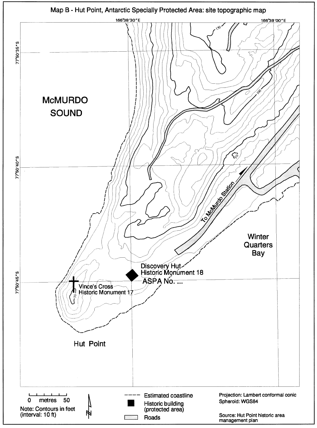
Specially Protected Area No. 28 Hut Point Historic Site No. 18, Ross Island Lat. 77°50'S; Long. 166°37'E
The designated Area consists solely of the hut situated near the south-western extremity of Hut Point, which is a small ice-free area protruding south-west from the Hut Point Peninsula and situated to the west of the United States McMurdo Station. The hut was built in February 1902 during the Discovery Expedition of 1901–1904 led by Captain Robert Falcon Scott, and used in his 1910–1913 expedition.

RESTRICTED AREAS
Specially Protected Area No. 29 Cape Adare, Historic Site No. 22 and its environs Lat. 71°18'S; Long. 170°09'E
Cape Adare is a (generally ice-free) prominent volcanic headland, at the northern extremity of Victoria Land, which marks the western approaches to the Ross Sea. The Area is located to the south-west of the Cape on the southern shore of Ridley Beach. It contains the huts built in February 1899 by the British Antarctic Expedition of 1898–1900 led by C E Borchgrevink and a hut built in 1911 for part of Scott’s 1910–1913 expedition.


RESTRICTED AREAS
Site of Special Scientific Interest No. 23 Svarthamaren, Múhlig-Hoffmannfjella, Dronning Maud Land Lat. 71°54'S; Long. 5°10'E
Svarthamaren is an ice-free area approximately 200 km inland from the front of the Fimbul ice shelf. The Area covers approximately 6.4 km2, and consists of the ice-free areas both of the Svarthamaren nunatak, and its immediate environs.
MAP A: Dronning Maud Land Location of map B shownMAP B: Svarthamaren and surroundings Svarthamaren, SSSI No. 23 sligthly left of centre


SCHEDULE 2ANTARCTIC HISTORIC SITES AND MONUMENTS
74. The south-west coast of Elephant Island between the southern side of Mensa Bay (61°10's, 55°24'W) and Cape Lookout (61°17'S, 55°13'W), including all of the foreshore and intertidal areas, contains the wreckage of a large wooden sailing ship.
Explanatory Note
(This note is not part of the Regulations)
The Regulations amend Schedules 1 and 2 to the Antarctic Regulations 1995 by adding further restricted areas and an historic site.
Options/Cymorth
Print Options
Official printed copies
PrintThe Whole Instrument

Mae deddfwriaeth ar gael mewn fersiynau gwahanol:
Y Diweddaraf sydd Ar Gael (diwygiedig):Y fersiwn ddiweddaraf sydd ar gael o’r ddeddfwriaeth yn cynnwys newidiadau a wnaed gan ddeddfwriaeth ddilynol ac wedi eu gweithredu gan ein tîm golygyddol. Gellir gweld y newidiadau nad ydym wedi eu gweithredu i’r testun eto yn yr ardal ‘Newidiadau i Ddeddfwriaeth’.
Gwreiddiol (Fel y’i Deddfwyd neu y’i Gwnaed): Mae'r wreiddiol fersiwn y ddeddfwriaeth fel ag yr oedd pan gafodd ei deddfu neu eu gwneud. Ni wnaed unrhyw newidiadau i’r testun.
Dewisiadau Agor
Dewisiadau gwahanol i agor deddfwriaeth er mwyn gweld rhagor o gynnwys ar y sgrin ar yr un pryd
Rhagor o Adnoddau
Gallwch wneud defnydd o ddogfennau atodol hanfodol a gwybodaeth ar gyfer yr eitem ddeddfwriaeth o’r tab hwn. Yn ddibynnol ar yr eitem ddeddfwriaeth sydd i’w gweld, gallai hyn gynnwys:
- y PDF print gwreiddiol y fel deddfwyd fersiwn a ddefnyddiwyd am y copi print
- rhestr o newidiadau a wnaed gan a/neu yn effeithio ar yr eitem hon o ddeddfwriaeth
- manylion rhoi grym a newid cyffredinol
- pob fformat o’r holl ddogfennau cysylltiedig
- slipiau cywiro
- dolenni i ddeddfwriaeth gysylltiedig ac adnoddau gwybodaeth eraill
Rhagor o Adnoddau
Defnyddiwch y ddewislen hon i agor dogfennau hanfodol sy’n cyd-fynd â’r ddeddfwriaeth a gwybodaeth am yr eitem hon o ddeddfwriaeth. Gan ddibynnu ar yr eitem o ddeddfwriaeth sy’n cael ei gweld gall hyn gynnwys:
- y PDF print gwreiddiol y fel gwnaed fersiwn a ddefnyddiwyd am y copi print
- slipiau cywiro
liciwch ‘Gweld Mwy’ neu ddewis ‘Rhagor o Adnoddau’ am wybodaeth ychwanegol gan gynnwys
- rhestr o newidiadau a wnaed gan a/neu yn effeithio ar yr eitem hon o ddeddfwriaeth
- manylion rhoi grym a newid cyffredinol
- pob fformat o’r holl ddogfennau cysylltiedig
- dolenni i ddeddfwriaeth gysylltiedig ac adnoddau gwybodaeth eraill
 Mae’r holl gynnwys ar gael dan Drwydded Llywodraeth Agored v3.0 ac eithrio ble nodir yn wahanol. Yn ychwanegol mae’r safle hwn â chynnwys sy’n deillio o EUR-Lex, a ailddefnyddiwyd dan delerau Penderfyniad y Comisiwn 2011/833/EU ar ailddefnyddio dogfennau o sefydliadau’r UE. Am ragor o wybodaeth gweler ddatganiad cyhoeddus Swyddfa Gyhoeddiadau’r UE ar ailddefnyddio.