- Y Diweddaraf sydd Ar Gael (Diwygiedig)
- Gwreiddiol (a wnaed Fel)
The Greenwich and Lewisham (London Borough Boundaries) Order 1993
You are here:
- Offerynnau Statudol y Deyrnas Unedig
- 1993 No. 1276
- Whole Instrument
- Blaenorol
- Nesaf

Pa Fersiwn
Dewisiadau Agor
Rhagor o Adnoddau
Status:
Dyma’r fersiwn wreiddiol (fel y’i gwnaed yn wreiddiol). This item of legislation is currently only available in its original format.
Statutory Instruments
1993 No. 1276
LOCAL GOVERNMENT, ENGLAND AND WALES
CHANGES IN LOCAL GOVERNMENT AREAS
The Greenwich and Lewisham (London Borough Boundaries) Order 1993
Made
12th May 1993
Laid before Parliament
20th May 1993
Coming into force
for the purposes referred to in article 1(2)
1st December 1993
for all other purposes
1st April 1994
The Secretary of State, in exercise of his powers under sections 51(2) and 67(4) of the Local Government Act 1972(1) and of all other powers enabling him in that behalf, hereby makes the following Order which gives effect to proposals submitted to him under sections 47, 48(1) and 51(1) of that Act, more than six weeks before the making of this Order, by the Local Government Boundary Commission for England:
Citation and commencement
1.—(1) This Order may be cited as the Greenwich and Lewisham (London Borough Boundaries) Order 1993.
(2) This Order shall come into force on 1st December 1993 for any purpose set out in regulation 4(1) of the Local Government Area Changes Regulations 1976(2).
(3) For all other purposes, this Order shall come into force on 1st April 1994.
Interpretation
2.—(1) In this Order—
“Greenwich” means the London borough of Greenwich;
“Lewisham” means the London borough of Lewisham;
“the map” means one of the 9 maps prepared by the Department of the Environment, marked “Maps of the Greenwich and Lewisham (London Borough Boundaries) Order 1993”, duly numbered for reference, and deposited in accordance with regulation 5 of the Local Government Area Changes Regulations 1976; and any reference to a ward is a reference to a ward of the London borough from or to which an area is transferred.
Transfers between Greenwich and Lewisham
3.—(1) Each area which is marked as shown in column 1 of the following Table on the map indicated in column 2 shall be transferred from Greenwich, and from the ward named in column 3 to Lewisham, and to the ward named in column 4.
TABLE
| (1) | (2) | (3) | (4) |
|---|---|---|---|
| Area marked— | On map— | Transferred from Greenwich, and from the following ward— | To Lewisham, and to the following ward— |
| D | 6 | Blackheath | Blackheath |
| B | 9 | Middle Park | St. Mildred |
A B | 5 6 | St. Alfege | Blackheath |
| A and C | 8 | Sutcliffe | St. Mildred |
| A | 1 | West | Evelyn |
| C | 6 | Vanbrugh | Blackheath |
A A, B, C & E A, C & E | 2 3 4 | West | Grinling Gibbons |
| F | 4 | West | Ladywell |
(2) Each area which is marked as shown on the following Table on the map indicated in column 2 shall be transferred from Lewisham, and from the ward named in column 3 to Greenwich, and to the ward named in column 4.
TABLE
| (1) | (2) | (3) | (4) |
|---|---|---|---|
| Area marked— | On map— | Transferred from Lewisham and from the following ward— | To Greenwich, and to the following ward— |
A B D B and D | 6 2 3 4 | Blackheath Grinling Gibbons | St. Alfege West |
| A and B | 7 | St. Margaret | Sutcliffe |
| A | 9 | St. Mildred | Middle Park |
C B and D | 7 8 | St. Mildred | Sutcliffe |
Town and country planning
4.—(1) In this article, “provision” means a provision of a development plan (as defined in section 336(1) of the Town and Country Planning Act 1990(3)).
(2) Any provision applying to an area transferred by this Order shall continue to apply to that area, notwithstanding the transfer, until replaced by a provision which so applies, and which is expressed to supersede the preserved provision.
Signed by authority of the Secretary of State for the Environment
Robin Squire
Parliamentary Under Secretary of State,
Department of the Environment
12th May 1993
Explanatory Note
(This note is not part of the Order)
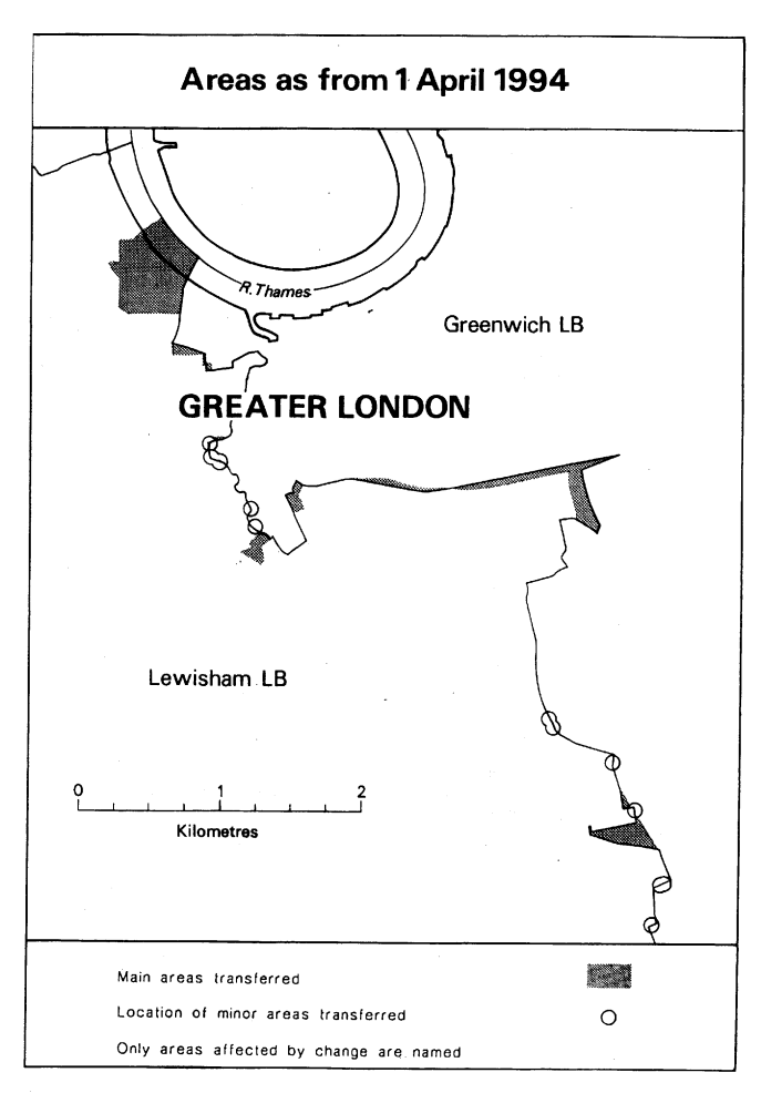
This Order makes changes to the boundary between the London boroughs of Greenwich and Lewisham.
The map and table at the end of this Note give a general guide to the areas affected and the changes made.
The table also gives an approximate figure for the total area of land involved (in hectares), and for the population affected.
For full details of the transfers made, the order maps (described in article 2) should be inspected.
Any person may inspect them at any reasonable time at the offices of the council for each London borough affected, and also at the offices of the Secretary of State for the Environment located in 2, Marsham Street, London SW1P 3EB.
The Local Government Area Changes Regulations 1976 (S. I. 1976/246, amended by S. I. 1978/247) contain general provisions regarding the effect of orders such as this one.
TABLE
TOTAL AREA AND POPULATION TRANSFERRED (Approximate)
| From Greenwich to Lewisham— | |
| Area: 40 hectares | Population: 870 |
| From Lewisham to Greenwich— | |
| Area: 10 hectares | Population: 2 |
DESCRIPTION OF CHANGES EFFECTED
1. Transfer to Lewisham of large dockland area by realignment of boundary to centre of Watergate Street. Area transferred includes Convoys Wharf, Dacca Street, Chester House, Sayes Court, Mulberry Court, Palmer’s Wharf, landing stages and part of the bed of the River Thames.
2. Transfer to Lewisham of area south of Blackheath Hill and east of Lewisham Road, including Robertson House, Doleman house, Holcroft House, car park, and part of Landale Court.
3. Transfer to Lewisham of area including part of Elverson Road and related housing development.
4. At Creek Road, west of Deptford High Street, transfer to Lewisham of Post Sorting Office and Lamerton Street.
5. Transfer to unite Colfe’s Schools sites and Old Colfeian Playing Fields in Greenwich.
6. Realignments in the following areas—
(a)at Blackheath, to western side of St. German’s Place;
(b)at No. 193, Woodyates Road;
(c)near Folly Pond, Shooters Hill Road;
(d)at Eltham Road/Woodvale Close and Upwood Road/Old Colfeians Sports Ground;
(e)at Deptford Creek, in vicinity of Skillcentre and Deptford Bridge;
(f)Coldbath Road/Brookmill Road;
(g)north of Dartmouth Hill/Hollyhedge House/Blackheath Vale, to centre of Shooters Hill Road;
(h)east of St. Paul’s Church, Deptford, to centre of Deptford Church Street/Berthon Street;
(i)at junction of Lee Road, Lee High Street and Eltham Road; and
(j)at rear of properties in Horncastle Road.
(1)
(3)
1990 c. 8. This definition was amended by the Planning and Compensation Act 1991 (c. 34), Schedule 4, paragraph 34.
Options/Help
Print Options
PrintThe Whole Instrument

Mae deddfwriaeth ar gael mewn fersiynau gwahanol:
Y Diweddaraf sydd Ar Gael (diwygiedig):Y fersiwn ddiweddaraf sydd ar gael o’r ddeddfwriaeth yn cynnwys newidiadau a wnaed gan ddeddfwriaeth ddilynol ac wedi eu gweithredu gan ein tîm golygyddol. Gellir gweld y newidiadau nad ydym wedi eu gweithredu i’r testun eto yn yr ardal ‘Newidiadau i Ddeddfwriaeth’.
Gwreiddiol (Fel y’i Deddfwyd neu y’i Gwnaed): Mae'r wreiddiol fersiwn y ddeddfwriaeth fel ag yr oedd pan gafodd ei deddfu neu eu gwneud. Ni wnaed unrhyw newidiadau i’r testun.
Dewisiadau Agor
Dewisiadau gwahanol i agor deddfwriaeth er mwyn gweld rhagor o gynnwys ar y sgrin ar yr un pryd
Rhagor o Adnoddau
Gallwch wneud defnydd o ddogfennau atodol hanfodol a gwybodaeth ar gyfer yr eitem ddeddfwriaeth o’r tab hwn. Yn ddibynnol ar yr eitem ddeddfwriaeth sydd i’w gweld, gallai hyn gynnwys:
- y PDF print gwreiddiol y fel deddfwyd fersiwn a ddefnyddiwyd am y copi print
- rhestr o newidiadau a wnaed gan a/neu yn effeithio ar yr eitem hon o ddeddfwriaeth
- manylion rhoi grym a newid cyffredinol
- pob fformat o’r holl ddogfennau cysylltiedig
- slipiau cywiro
- dolenni i ddeddfwriaeth gysylltiedig ac adnoddau gwybodaeth eraill
 Mae’r holl gynnwys ar gael dan Drwydded Llywodraeth Agored v3.0 ac eithrio ble nodir yn wahanol. Yn ychwanegol mae’r safle hwn â chynnwys sy’n deillio o EUR-Lex, a ailddefnyddiwyd dan delerau Penderfyniad y Comisiwn 2011/833/EU ar ailddefnyddio dogfennau o sefydliadau’r UE. Am ragor o wybodaeth gweler ddatganiad cyhoeddus Swyddfa Gyhoeddiadau’r UE ar ailddefnyddio.