- Y Diweddaraf sydd Ar Gael (Diwygiedig)
- Gwreiddiol (a wnaed Fel)
The Croydon, Merton and Sutton (London Borough Boundaries) Order 1993
You are here:
- Offerynnau Statudol y Deyrnas Unedig
- 1993 No. 2350
- Explanatory Note

Pa Fersiwn
Dewisiadau Agor
Rhagor o Adnoddau
Status:
Dyma’r fersiwn wreiddiol (fel y’i gwnaed yn wreiddiol). This item of legislation is currently only available in its original format.
Explanatory Note
(This note is not part of the Order)
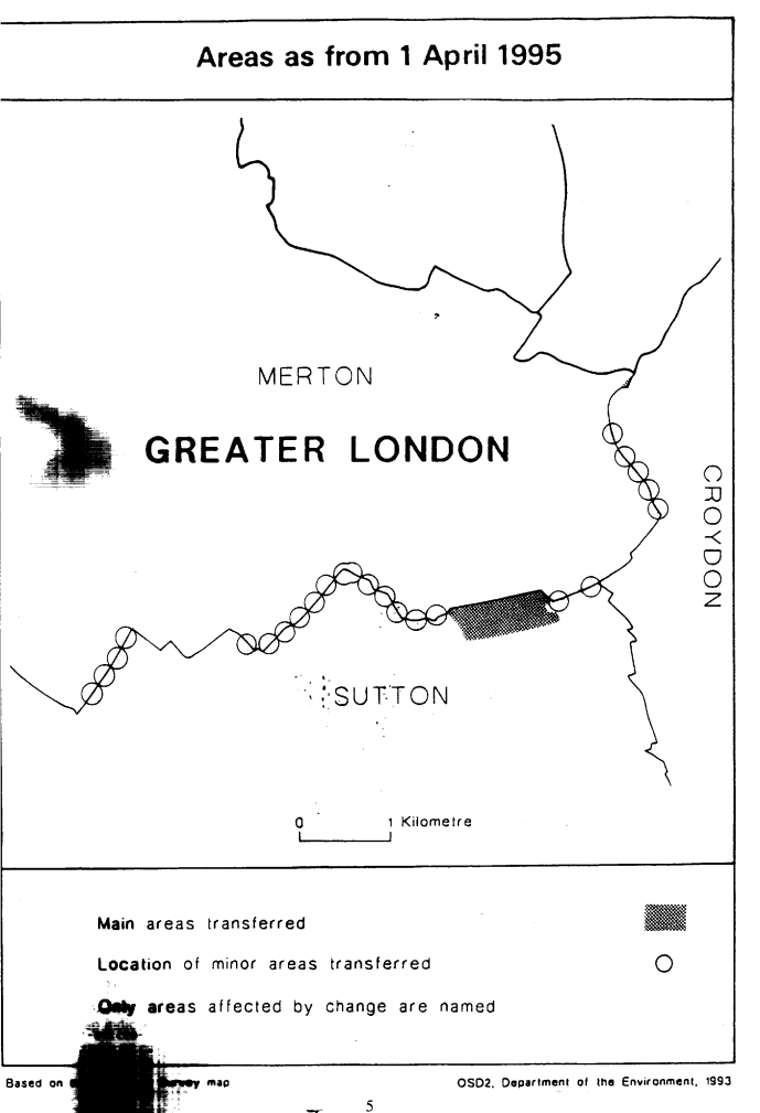
This Order makes minor changes in the boundary of the London borough of Merton with the London borough of Croydon, and with the London borough of Sutton. The map and table forming part of this Note give a general guide to the areas affected, and their size and population (in total). For full details of the transfers made, the order maps (described in article 2) should be inspected.
Any person may inspect them at any reasonable time at the offices of the council for each London borough affected, and also at the offices of the Secretary of State for the Environment located in 2, Marsham Street, London SW1P 3EB.
Consequential changes are made to petty sessional divisions and coroners' districts. No parishes are affected. The Local Government Area Changes Regulations 1976 (S. I.1976/246, amended by S. I.1978/247) contain general provisions regarding the effect of orders such as this one.
TABLE
| TRANSFERS BETWEEN— | DESCRIPTION OF CHANGES— |
|---|---|
| CROYDON AND MERTON Article 3 Transferred from Merton— Area: less than 1 hectare Population: Nil Transferred to Merton— Area: less than 1 hectare Population: Nil | Realignments in vicinity of Turle Road/Abingdon Road to unite National Westminster Sports Ground in Merton. Minor realignment at No. 286, Northborough Road. Minor realignments to more defined boundary in South Lodge Avenue/ Recreation Way/Recreation Ground off Recreation Way. |
| MERTON AND SUTTON Article 4 Transferred from Merton— Area: 40 hectares Population: 5 Transferred to Merton— Area: 2 Population: Nil | Transfer to Sutton of area west of Beddington Lane, including part of Beddington Sewage Works Realignments to north-west side of Stonecot Hill and Epsom Road, Bishopsford Road, southern curtilage of NAAFI Sports Ground, north of Poulter Park. In vicinity of Willow Lane industrial Estate, realignment of boundary to (i) centre of River Wandle; then (ii) southern side of Wates Way and Goat Road; then (iii) across London Road to south-eastern corner of Mitcham Common. Realignments along Brookmead Road/Red House Road between Beddington Lane and Mitcham Road. |
Options/Help
Print Options
PrintThe Whole Instrument
PrintThis Explanatory Note only

Mae deddfwriaeth ar gael mewn fersiynau gwahanol:
Y Diweddaraf sydd Ar Gael (diwygiedig):Y fersiwn ddiweddaraf sydd ar gael o’r ddeddfwriaeth yn cynnwys newidiadau a wnaed gan ddeddfwriaeth ddilynol ac wedi eu gweithredu gan ein tîm golygyddol. Gellir gweld y newidiadau nad ydym wedi eu gweithredu i’r testun eto yn yr ardal ‘Newidiadau i Ddeddfwriaeth’.
Gwreiddiol (Fel y’i Deddfwyd neu y’i Gwnaed): Mae'r wreiddiol fersiwn y ddeddfwriaeth fel ag yr oedd pan gafodd ei deddfu neu eu gwneud. Ni wnaed unrhyw newidiadau i’r testun.
Dewisiadau Agor
Dewisiadau gwahanol i agor deddfwriaeth er mwyn gweld rhagor o gynnwys ar y sgrin ar yr un pryd
Rhagor o Adnoddau
Gallwch wneud defnydd o ddogfennau atodol hanfodol a gwybodaeth ar gyfer yr eitem ddeddfwriaeth o’r tab hwn. Yn ddibynnol ar yr eitem ddeddfwriaeth sydd i’w gweld, gallai hyn gynnwys:
- y PDF print gwreiddiol y fel deddfwyd fersiwn a ddefnyddiwyd am y copi print
- rhestr o newidiadau a wnaed gan a/neu yn effeithio ar yr eitem hon o ddeddfwriaeth
- manylion rhoi grym a newid cyffredinol
- pob fformat o’r holl ddogfennau cysylltiedig
- slipiau cywiro
- dolenni i ddeddfwriaeth gysylltiedig ac adnoddau gwybodaeth eraill
 Mae’r holl gynnwys ar gael dan Drwydded Llywodraeth Agored v3.0 ac eithrio ble nodir yn wahanol. Yn ychwanegol mae’r safle hwn â chynnwys sy’n deillio o EUR-Lex, a ailddefnyddiwyd dan delerau Penderfyniad y Comisiwn 2011/833/EU ar ailddefnyddio dogfennau o sefydliadau’r UE. Am ragor o wybodaeth gweler ddatganiad cyhoeddus Swyddfa Gyhoeddiadau’r UE ar ailddefnyddio.