- Latest available (Revised)
- Original (As made)
The M6 Motorway: Widening between Junctions 20 and 21A (Thelwall Viaduct) and Connecting Roads Scheme 1990
You are here:
- UK Statutory Instruments
- 1990 No. 2659
- Schedules only

What Version
More Resources
Status:
This is the original version (as it was originally made). This item of legislation is currently only available in its original format.
SCHEDULE 1ROUTE OF THE MOTORWAY
A route, about 1330 metres in length, commencing at a point on the M6 Motorway 40 metres south of the point where it crosses the centre of Warrington Road, Lymm in the County of Cheshire (marked “A” on the deposited plan) and proceeding in a generally northerly direction to rejoin that Motorway at a point 380 metres south of the point where it crosses the centre of Manchester Road, Warrington in the County of Cheshire (marked “B” on the deposited plan).
SCHEDULE 2ROUTES OF THE CONNECTING ROADS
Junction with A50 Cliff Lane at Lymm Interchange, Junction 20
1. A route from the northbound carriageway of the M6 Motorway to a new roundabout to be constructed on the A50 Cliff Lane (west of the existing roundabout). This new slip road is given the reference number 1 on the deposited plan.
Junction with M62 motorway at Junction 21A
2. A route from the westbound carriageway and a route from the eastbound carriageway of the M62 Motorway to the southbound carriageway of the M6 Motorway. These new slip roads are given the reference numbers 2 and 3, respectively, on the deposited plan.
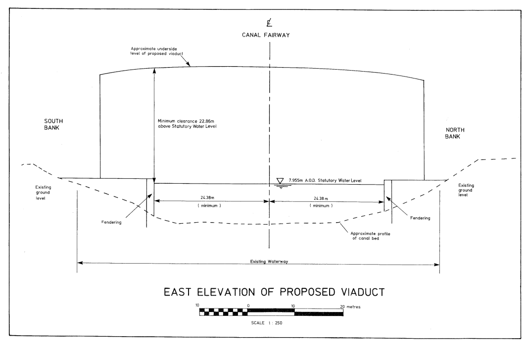
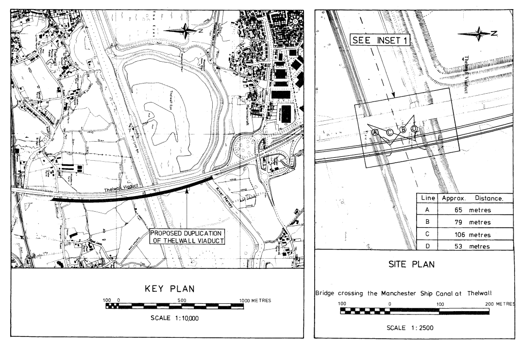
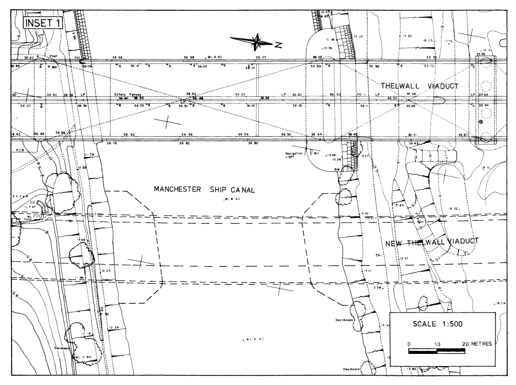
SCHEDULE 3 WITH KEY PLAN AND SITE PLANPLANS AND SPECIFICATIONS FOR THE VIADUCT CROSSING THE MANCHESTER SHIP CANAL AT THELWALL
Points of Commencement and Termination
From a point south of the centreline of the Manchester Ship Canal in the Borough of Warrington in the County of Cheshire 65 metres north east from the centre of the northern face of the Thelwall Viaduct pier on the southern bank of the canal and 79 metres south east from the centre of the southern face of the Thelwall Viaduct pier on the northern bank of the canal.
To a point north of the centreline of the Manchester Ship Canal 106 metres north east from the centre of the northern face of the Thelwall Viaduct pier on the southern bank of the canal and 53 metres east from the centre of the southern face of the Thelwall Viaduct pier on the northern bank of the canal.
Construction
Composite steel girder and reinforced concrete deck on reinforced concrete piers.
Headroom
22.86 metres minimum headroom above statutory water level above canal fairway tapering to 20.62 metres above statutory water level 5.64 metres from the edge of the fairway.
Diversion of the Canal
This would have the effect of diverting the southern bank of the waterway northwards by a maximum distance of 16 metres and the northern bank of the waterway southwards by a maximum distance of 14 metres. The existing waterway width of 79 metres would be reduced to a minimum width of 48.76 metres.
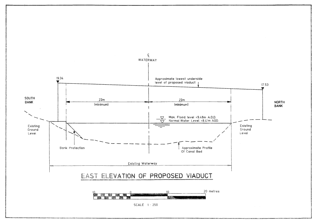
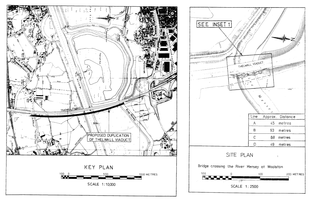
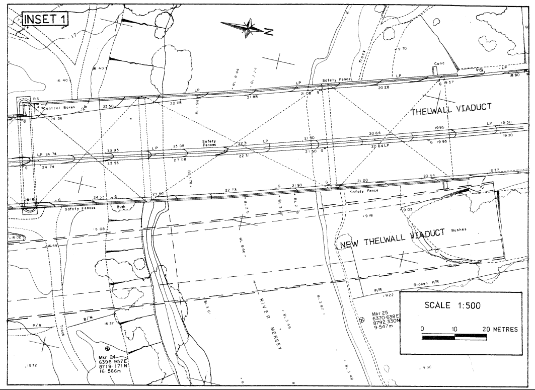
SCHEDULE 4 WITH KEY PLAN AND SITE PLANPLANS AND SPECIFICATIONS FOR THE VIADUCT CROSSING THE RIVER MERSEY AT WOOLSTON
Points of Commencement and Termination
From a point south of the centreline of the River Mersey in the Borough of Warrington in the County of Cheshire 45 metres north of the north east corner of the pilecap of Thelwall Viaduct Pier HH and 93 metres south east of the north east corner of the eastern wingwall of the northern abutment of Thelwall Viaduct.
To a point north of the centreline of the River Mersey 88 metres north of the north east corner of the pilecap of Thelwall Viaduct pier HH and 49 metres south east of the north east corner of the eastern wingwall of the northern abutment of Thelwall Viaduct.
Construction
Composite steel girder and reinforced concrete deck on reinforced concrete piers.
Headroom
Headroom to be not less than 9.12m above normal navigation level which is 8.41m above Ordnance Datum to be maintained for a distance of 22 metres each side of the centreline of the navigable waterway.
Waterway
As defined by the above limits at normal navigation level.
Diversion of the Waterway
This would have the effect of diverting the southern bank of the waterway northwards by a maximum distance of 6 metres. The existing waterway width of 50 metres would be reduced to a minimum width of 44 metres.
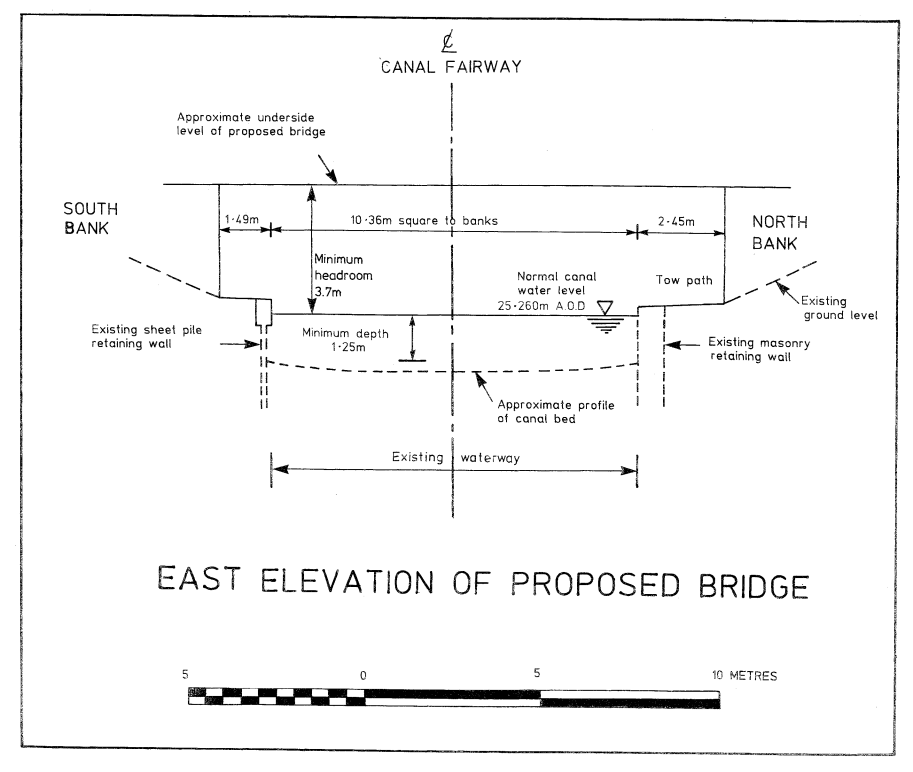
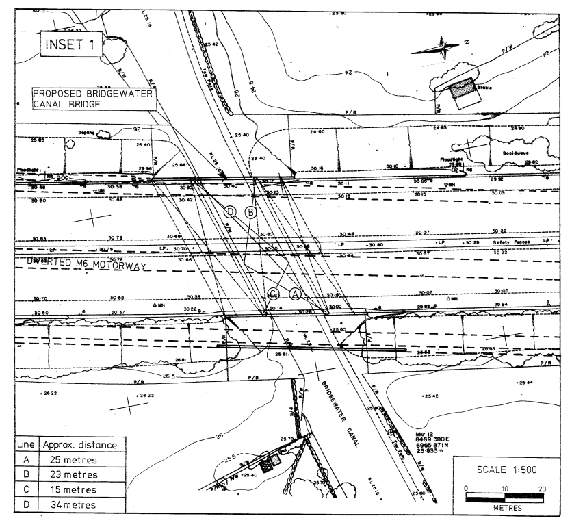
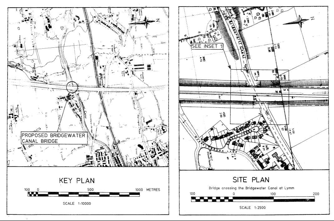
SCHEDULE 5 WITH KEY PLAN AND SITE PLANPLANS AND SPECIFICATIONS FOR THE BRIDGE CROSSING THE BRIDGEWATER CANAL AT LYMM
Points of Commencement and Termination
From a point south of the centreline of the Bridgewater Canal in the Borough of Warrington in the County of Cheshire 25 metres south west from the easternmost column of the northern pier of the Bridgewater Canal Bridge and 23 metres south east from the westernmost column of the northern pier of the Bridgewater Canal Bridge.
To a point north of the centreline of the Bridgewater Canal 15 metres north west from the easternmost column of the southern pier of the Bridgewater Canal Bridge and 34 metres north east from the westernmost column of the southern pier of the Bridgewater Canal Bridge.
Construction
Composite steel girder and reinforced concrete deck on reinforced concrete piers.
Headroom
3.7 metres minimum headroom above Normal Canal Water Level.
Options/Help
Print Options
PrintThe Whole Instrument
PrintThe Schedules only

Legislation is available in different versions:
Latest Available (revised):The latest available updated version of the legislation incorporating changes made by subsequent legislation and applied by our editorial team. Changes we have not yet applied to the text, can be found in the ‘Changes to Legislation’ area.
Original (As Enacted or Made): The original version of the legislation as it stood when it was enacted or made. No changes have been applied to the text.
Opening Options
Different options to open legislation in order to view more content on screen at once
More Resources
Access essential accompanying documents and information for this legislation item from this tab. Dependent on the legislation item being viewed this may include:
- the original print PDF of the as enacted version that was used for the print copy
- lists of changes made by and/or affecting this legislation item
- confers power and blanket amendment details
- all formats of all associated documents
- correction slips
- links to related legislation and further information resources
 All content is available under the Open Government Licence v3.0 except where otherwise stated. This site additionally contains content derived from EUR-Lex, reused under the terms of the Commission Decision 2011/833/EU on the reuse of documents from the EU institutions. For more information see the EUR-Lex public statement on re-use.