- Latest available (Revised)
- Original (As made)
The Wester Ross Marine Conservation Order 2016
You are here:
- Scottish Statutory Instruments
- 2016 No. 88
- Whole Instrument
- Previous
- Next

What Version
More Resources
Status:
This is the original version (as it was originally made). This item of legislation is currently only available in its original format.
Scottish Statutory Instruments
2016 No. 88
Environmental Protection
Marine Management
The Wester Ross Marine Conservation Order 2016
Made
3rd February 2016
Laid before the Scottish Parliament
4th February 2016
Coming into force
23rd March 2016
The Scottish Ministers make the following Order in exercise of the powers conferred by sections 1 and 2A of the Inshore Fishing (Scotland) Act 1984(1), sections 85(1)(a), (2) and (4), 86(1) and (3), 88(1) and (2) and 92(1) and (5) of the Marine (Scotland) Act 2010(2) and all other powers enabling them to do so.
In accordance with section 85(1)(a) of the Marine (Scotland) Act 2010, this Order is made for the purpose of furthering the stated conservation objectives for the Wester Ross MPA(3) in so far as the conservation objectives relate to burrowed mud, circalittoral muddy sand communities, flame shell beds, kelp and seaweed communities on sublittoral sediment, maerl beds, maerl or coarse shell gravel with burrowing sea cucumbers and northern feather star aggregations on mixed substrata(4).
In accordance with section 1(1) of the Inshore Fishing (Scotland) Act 1984, the Scottish Ministers have consulted such bodies as they considered appropriate.
In accordance with section 87(2) of the Marine (Scotland) Act 2010, the Scottish Ministers have sent a copy of a draft of this Order to persons whom they considered were likely to be interested in or affected by the making of this Order.
In accordance with section 87(3) of the Marine (Scotland) Act 2010, the Scottish Ministers have placed a copy of a draft of this Order in such place as they considered was likely to be most convenient for the purpose of enabling it to be inspected by persons likely to be affected by the making of this Order.
In accordance with section 87(6) and (7) of the Marine (Scotland) Act 2010, the Scottish Ministers have published notice of their proposal to make this Order.
Citation and commencement
1. This Order may be cited as the Wester Ross Marine Conservation Order 2016 and comes into force on 23rd March 2016.
Interpretation
2. In this Order—
“boundary line” means a boundary delineated by a line as described in Schedule 1 or 2;
“co-ordinate” means a co-ordinate of latitude and longitude according to the World Geodetic System 1984(5);
“the protected area” means the area described in article 3; and
“Wester Ross MPA” means that area designated as a nature conservation marine protected area by, and described in article 3 of, the Wester Ross Nature Conservation Marine Protected Area Order 2014(6).
The protected area
3. For the purposes of this Order, the area protected by it is—
(a)the seabed and subsoil; and
(b)all of the water covering the seabed,
within the Wester Ross MPA.
Prohibited and regulated activities
4.—(1) Paragraphs (2) and (3) apply in order to further the stated conservation objectives of the Wester Ross MPA in relation to burrowed mud, circalittoral muddy sand communities, flame shell beds, kelp and seaweed communities on sublittoral sediment, maerl beds, maerl or coarse shell gravel with burrowing sea cucumbers and northern feather star aggregations on mixed substrata.
(2) A person must not deploy (by any means) or use any fishing gear within the protected area.
(3) While a fishing vessel is within the protected area the master of the vessel must ensure that any fishing gear carried on board the vessel is properly lashed and stowed in such a way that it may not be readily used.
(4) Paragraphs (2) and (3) do not apply to the deployment or use of—
(a)any fishing gear within the protected area for the purpose of saving life, or for the purpose of securing the safety of a vessel, aircraft or marine structure;
(b)a demersal trawl, whether that be a single demersal trawl or a twin rig demersal trawl, (other than a beam trawl) by a vessel with an engine power not exceeding 500 kilowatts, and registered as such under Part II of the Merchant Shipping Act 1995(7), within that part of the protected area which is described by Schedule 1; or
(c)a single demersal trawl (other than a beam trawl) by a vessel with an engine power not exceeding 500 kilowatts, and registered as such under Part II of the Merchant Shipping Act 1995, within those parts of the protected area which are described by Schedule 2.
(5) In this article—
“beam trawl” means a type of demersal trawl which has its mouth extended by a beam, bar or other rigid device;
“demersal seine net” means an encircling net, attached to ropes, which is laid on, and towed across, the seabed;
“demersal trawl” means a net which is towed along the seabed;
“dredge” means—
(a)
a mechanical dredge; or
(b)
a suction dredge which raises material, fish and shellfish from the seabed with gear by the use of a solids pump, air lift or water jets which dig into the seabed;
“fishing gear” means any beam trawl, demersal seine net, demersal trawl, dredge, and any rope or wire associated with the gear;
“single demersal trawl” means a single net towed by a two warp rig in which the net has a single groundrope bosom; and
“twin rig demersal trawl” means two separate nets, each with a single groundrope bosom, which are towed on the seabed simultaneously by a two or a three warp rig.
Authorisation for the purpose of scientific research
5.—(1) The Scottish Ministers may, following written application to them, issue a permit authorising the activity mentioned in paragraph (2) which would, apart from any such permit, be unlawful under this Order.
(2) The activity mentioned in this paragraph is the deployment or use of any fishing gear for the purpose of scientific research.
(3) The Scottish Ministers must not issue a permit unless they are satisfied that there is no significant risk of the activity hindering the achievement of the stated conservation objectives for the Wester Ross MPA.
(4) In this article, “fishing gear” has the same meaning as in article 4(5).
Disapplication of exception to the offences under sections 94 and 95 of the Marine (Scotland) Act 2010
6.—(1) Paragraph (b) of section 97(1) of the 2010 Act does not apply in relation to—
(a)an offence under section 94 of the 2010 Act of contravening this Order;
(b)an offence under section 95 of the 2010 Act committed in relation to the protected area.
(2) In this article “the 2010 Act” means the Marine (Scotland) Act 2010.
Revocations
7.—(1) In Schedule 1 to the Inshore Fishing (Prohibition of Fishing and Fishing Methods) (Scotland) Order 2004(8), the entry relating to Little Loch Broom and Gruinard Bay, listed as item 10 in column 1, is revoked.
(2) The Wester Ross Marine Conservation Order 2015(9) is revoked.
RICHARD LOCHHEAD
A member of the Scottish Government
St Andrew’s House,
Edinburgh
3rd February 2016
Articles 2 and 4(4)(b)
SCHEDULE 1AREA WHERE DEMERSAL TRAWLING (WHETHER THAT BE A SINGLE DEMERSAL TRAWL OR A TWIN RIG DEMERSAL TRAWL BUT NOT A BEAM TRAWL) BY SPECIFIED VESSELS IS ALLOWED
For the purposes of articles 2 and 4(4)(b) the part of the protected area described in this Schedule is enclosed by the boundary lines which are described below, in each case by reference to the co-ordinates of the points joined by a line and a topographical description of the line—
| Boundary Line | Set of co-ordinates of points which the boundary line joins | Topographic description of boundary line |
|---|---|---|
| 1. | A to B | Geodesic line |
| 2. | B to C | Geodesic line |
| 3. | C to D | Geodesic line |
| 4. | D to E | Geodesic line |
| 5. | E to A | Geodesic line |
Where—
“A” is 57°55.271′N, 005°47.161′W;
“B” is 57°59.608′N, 005°45.412′W;
“C” is 58°06.929′N, 005°31.505′W;
“D” is 58°01.352′N, 005°32.642′W; and
“E” is 57°55.867′N, 005°42.408′W.
Articles 2 and 4(4)(c)
SCHEDULE 2AREAS WHERE SINGLE DEMERSAL TRAWLING (BUT NOT BEAM TRAWLING) BY SPECIFIED VESSELS IS ALLOWED
For the purposes of articles 2 and 4(4)(c) the parts of the protected area described in this Schedule are enclosed by the boundary lines which are described below, in each case by reference to the co-ordinates of the points joined by a line and a topographical description of the line—
PART 1
| Boundary Line | Set of co-ordinates of points which the boundary line joins | Topographic description of boundary line |
|---|---|---|
| 1. | F to G | Geodesic line |
| 2. | G to H | Geodesic line |
| 3. | H to I | Geodesic line |
| 4. | I to J | Geodesic line |
| 5. | J to K | Geodesic line |
| 6. | K to L | Geodesic line |
| 7. | L to M | Geodesic line |
| 8. | M to N | Geodesic line |
| 9. | N to O | Geodesic line |
| 10. | O to P | Geodesic line |
| 11. | P to Q | Geodesic line |
| 12. | Q to R | Geodesic line |
| 13. | R to S | Geodesic line |
| 14. | S to T | Geodesic line |
| 15. | T to U | Geodesic line |
| 16. | U to V | Geodesic line |
| 17. | V to W | Geodesic line |
| 18. | W to X | Geodesic line |
| 19. | X to Y | Geodesic line |
| 20. | Y to Z | Geodesic line |
| 21. | Z to AA | Geodesic line |
| 22. | AA to AB | Geodesic line |
| 23. | AB to AC | Geodesic line |
| 24. | AC to AD | Geodesic line |
| 25. | AD to AE | Geodesic line |
| 26. | AE to F | Geodesic line |
Where—
“F” is 57°53.622′N, 005°32.377′W;
“G” is 57°55.915′N, 005°32.316′W;
“H” is 57°56.287′N, 005°31.073′W;
“I” is 57°58.424′N, 005°24.009′W;
“J” is 57°58.431′N, 005°22.526′W;
“K” is 57°57.304′N, 005°22.509′W;
“L” is 57°57.149′N, 005°22.295′W;
“M” is 57°57.052′N, 005°17.491′W;
“N” is 57°56.041′N, 005°13.208′W;
“O” is 57°55.739′N, 005°13.569′W;
“P” is 57°56.273′N, 005°16.944′W.
“Q” is 57°55.948′N, 005°17.576′W;
“R” is 57°55.319′N, 005°14.418′W;
“S” is 57°55.183′N, 005°14.512′W;
“T” is 57°55.032′N, 005°15.816′W;
“U” is 57°54.722′N, 005°17.504′W;
“V” is 57°54.984′N, 005°18.425′W;
“W” is 57°54.920′N, 005°19.217′W;
“X” is 57°56.420′N, 005°21.191′W;
“Y” is 57°56.680′N, 005°21.860′W;
“Z” is 57°56.584′N, 005°22.566′W;
“AA” is 57°56.123′N, 005°24.531′W.
“AB” is 57°55.424′N, 005°25.348′W;
“AC” is 57°54.371′N, 005°25.944′W;
“AD” is 57°54.865′N, 005°30.022′W; and
“AE” is 57°53.741′N, 005°30.771′W.
PART 2
| Boundary Line | Set of co-ordinates of points which the boundary line joins | Topographic description of boundary line |
|---|---|---|
| 1. | AF to AG | Geodesic line |
| 2. | AG to AH | Geodesic line |
| 3. | AH to AI | Geodesic line |
| 4. | AI to AJ | Geodesic line |
| 5. | AJ to AK | Geodesic line |
| 6. | AK to AL | Geodesic line |
| 7. | AL to AM | Geodesic line |
| 8. | AM to AN | Geodesic line |
| 9. | AN to AO | Geodesic line |
| 10. | AO to AF | Geodesic line |
Where—
“AF” is 57°57.871′N, 005°18.283′W;
“AG” is 57°58.332′N, 005°17.256′W;
“AH” is 57°58.157′N, 005°15.054′W;
“AI” is 57°57.782′N, 005°14.880′W;
“AJ” is 57°57.371′N, 005°13.673′W;
“AK” is 57°57.319′N, 005°12.235′W.
“AL” is 57°56.987′N, 005°12.209′W;
“AM” is 57°57.047′N, 005°14.148′W;
“AN” is 57°56.944′N, 005°15.167′W; and
“AO” is 57°57.469′N, 005°17.357′W.
EXPLANATORY NOTE
(This note is not part of the Order)
Article 11(1) of Regulation (EU) No 1380/2013 of the European Parliament and of the Council on the Common Fisheries Policy (OJ L 354, 28.12.2013, p.22) empowers EU member States to adopt conservation measures which are necessary for compliance with obligations under EU environmental legislation.
The Wester Ross Nature Conservation Marine Protected Area Order 2014 (“the 2014 Order”) designated that part of the Scottish marine area which is adjacent to Wester Ross as a nature conservation marine protected area (“Wester Ross MPA”). The 2014 Order provides that a range of marine habitats, geomorphological features and one low or limited mobility species are protected features within the Wester Ross MPA.
This Order furthers the stated conservation objectives for the Wester Ross MPA insofar as they relate to burrowed mud, circalittoral muddy sand communities, flame shell beds, kelp and seaweed communities on sublittoral sediment, maerl beds, maerl or coarse shell gravel with burrowing sea cucumbers and northern feather star aggregations on mixed substrata.
Article 3 describes the area protected by this Order (“the protected area”). It is the area which is designated under the 2014 Order as the Wester Ross MPA.
Article 4 prohibits and regulates activities within the protected area.
Article 4(2) provides that a person must not deploy or use any fishing gear within the protected area. The term “fishing gear” is defined in article 4(5) of the Order.
Article 4(3) regulates the storage of fishing gear on fishing vessels within the protected area.
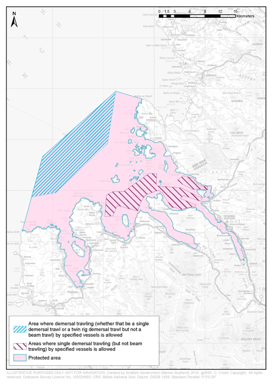
Article 4(4) provides that the provision made by the Order in prohibiting and regulating activities is subject to certain specified exceptions. Article 4(4)(a) provides that the prohibitions and regulations do not apply to activities carried out in the protected area for the purpose of saving life or for the purpose of securing the safety of a vessel, aircraft or marine structure. Article 4(4)(b) provides that demersal trawling, whether that be demersal trawling either by a single net or by two nets, (other than beam trawling) by fishing vessels with engines, the power of which do not exceed 500 kilowatts and registered as such under Part II of the Merchant Shipping Act 1995, is permitted within certain specified parts of the protected area, as described in Schedule 1. Article 4(4)(c) provides that single demersal trawling (other than beam trawling) by fishing vessels with engines, as described above, is permitted within certain specified parts of the protected area, as described in Schedule 2.
Article 5 provides that the Scottish Ministers may issue permits authorising fishing within the protected area only for the purpose of scientific research which would, apart from such a permit, be unlawful under the Order. The article makes provision regarding the procedure which applies to the making of applications for permits and the determination of such applications.
Article 6 provides that paragraph (b) of section 97(1) of the Marine (Scotland) Act 2010 does not apply in relation to an offence under section 94 of the 2010 Act of contravening this Order or an offence under section 95 of the 2010 Act committed in relation to the protected area.
Article 7 revokes the entry relating to Little Loch Broom and Gruinard Bay, listed as item 10 of Schedule 1 to the Inshore Fishing (Prohibition of Fishing and Fishing Methods) (Scotland) Order 2004, and the Wester Ross Marine Conservation Order 2015 (“the 2015 Order”). The 2015 Order prohibited the deployment or use of dredges, and regulated the storage of dredges on fishing vessels within the Wester Ross MPA. The measures which were made by that Order on an urgent basis under the powers within section 88 of the 2010 Act are re-made on a permanent basis by this Order.
A person who contravenes this Order commits an offence and is liable on summary conviction to a fine of up to £50,000, and on conviction on indictment to an unlimited fine.
A business and regulatory impact assessment has been prepared in relation to this Order and placed in the Scottish Parliament Information Centre. A copy of this can be obtained from Marine Scotland, the Scottish Government, Victoria Quay, Edinburgh, EH6 6QQ.
An illustrative map showing the Wester Ross MPA, and the parts in respect of which article 4(4) of the Order applies, is attached to this note.
(1)
1984 c.26. Section 1 was amended by the Inshore Fishing (Scotland) Act 1994 (c.27), section 1 and by S.I. 1999/1820. Section 2A was inserted by the Environment Act 1995 (c.25), section 103(2). The functions of the Secretary of State were transferred to the Scottish Ministers by virtue of section 53 of the Scotland Act 1998 (c.46).
(2)
(3)
The Wester Ross MPA was designated by the Wester Ross Nature Conservation Marine Protected Area Order 2014 (“the 2014 Order”). The 2014 Order is available at http://www.scotland.gov.uk/Resource/0045/00456503.pdf
(4)
The conservation objectives are stated in article 5 of the 2014 Order and the protected features are stated in Schedule 2 to that Order.
(5)
The World Geodetic System 1984 is defined at paragraph 2.1 of the United States National Imagery and Mapping Agency Technical Report TR8350.2, third edition, amendment 1 of 3rd January 2000 entitled “Department of Defense World Geodetic System 1984” ( http://earth-info.nga.mil/GandG/publications/tr8350.2/wgs84fin.pdf)
(6)
The Wester Ross Nature Conservation Marine Protected Area Order 2014 (“the 2014 Order”) was made by the Scottish Ministers under powers within the Marine (Scotland) Act 2010, including section 67(1)(a). By virtue of section 165(3) of that Act the 2014 Order is not a Scottish statutory instrument but a Scottish Ministerial Order. The 2014 Order is available at http://www.scotland.gov.uk/Resource/0045/00456503.pdf
(7)
(8)
(9)
Options/Help
Print Options
PrintThe Whole Instrument

Legislation is available in different versions:
Latest Available (revised):The latest available updated version of the legislation incorporating changes made by subsequent legislation and applied by our editorial team. Changes we have not yet applied to the text, can be found in the ‘Changes to Legislation’ area.
Original (As Enacted or Made): The original version of the legislation as it stood when it was enacted or made. No changes have been applied to the text.
Opening Options
Different options to open legislation in order to view more content on screen at once
Policy Note
Policy Note sets out a brief statement of the purpose of a Scottish Statutory Instrument and provides information about its policy objective and policy implications. They aim to make the Scottish Statutory Instrument accessible to readers who are not legally qualified and accompany any Scottish Statutory Instrument or Draft Scottish Statutory Instrument laid before the Scottish Parliament from July 2012 onwards. Prior to this date these type of notes existed as ‘Executive Notes’ and accompanied Scottish Statutory Instruments from July 2005 until July 2012.
More Resources
Access essential accompanying documents and information for this legislation item from this tab. Dependent on the legislation item being viewed this may include:
- the original print PDF of the as enacted version that was used for the print copy
- lists of changes made by and/or affecting this legislation item
- confers power and blanket amendment details
- all formats of all associated documents
- correction slips
- links to related legislation and further information resources
More Resources
Use this menu to access essential accompanying documents and information for this legislation item. Dependent on the legislation item being viewed this may include:
- the original print PDF of the as made version that was used for the print copy
- correction slips
Click 'View More' or select 'More Resources' tab for additional information including:
- lists of changes made by and/or affecting this legislation item
- confers power and blanket amendment details
- all formats of all associated documents
- links to related legislation and further information resources
 All content is available under the Open Government Licence v3.0 except where otherwise stated. This site additionally contains content derived from EUR-Lex, reused under the terms of the Commission Decision 2011/833/EU on the reuse of documents from the EU institutions. For more information see the EUR-Lex public statement on re-use.