The Carmarthenshire and Pembrokeshire (Clynderwen, Cilymaenllwyd and Henllanfallteg) Order 2002
and the National Assembly for Wales having decided to give effect to these proposals with modifications the effect of the modifications being to include the transfer of the land and property known as “Troed y Rhiw”;
and more than six weeks having elapsed since those proposals were made;
Name and commencement1.
(1)
This Order is called the Carmarthenshire and Pembrokeshire (Clynderwen, Cilymaenllwyd and Henllanfallteg) Order 2002.
(2)
This Order shall come into force on 1 April 2003 which is the appointed day for the purposes of the Regulations, except that for the purpose of all proceedings preliminary or relating to an election to be held on or after that date this Order shall come into force on the day after that on which it is made.
Interpretation2.
In this Order —
“boundary map A” (“ map ffiniau A”) means the map prepared by the National Assembly for Wales and marked “Map A of the Carmarthenshire and Pembrokeshire (Clynderwen, Cilymaenllwyd and Henllanfallteg) Order 2002” and deposited in accordance with Regulation 5 of the Regulations;
“boundary map B” (“map ffiniau B”) means the map prepared by the National Assembly for Wales and marked “Map B of the Carmarthenshire and Pembrokeshire (Clynderwen, Cilymaenllwyd and Henllanfallteg) Order 2002” and deposited in accordance with Regulation 5 of the Regulations;
“boundary map C” (“map ffiniau C”) means the map prepared by the National Assembly for Wales and marked “Map C of the Carmarthenshire and Pembrokeshire (Clynderwen, Cilymaenllwyd and Henllanfallteg) Order 2002” and deposited in accordance with Regulation 5 of the Regulations;
“boundary map D” (“map ffiniau CH”) means the map prepared by the National Assembly for Wales and marked “Map D of the Carmarthenshire and Pembrokeshire (Clynderwen, Cilymaenllwyd and Henllanfallteg) Order 2002” and deposited in accordance with Regulation 5 of the Regulations;
“boundary map E” (“map ffiniau D”) means the map prepared by the National Assembly for Wales and marked “Map E of the Carmarthenshire and Pembrokeshire (Clynderwen, Cilymaenllwyd and Henllanfallteg) Order 2002” and deposited in accordance with Regulation 5 of the Regulations;
- “the Regulations” (“y Rheoliadau”) means the Local Government Area Changes Regulations 1976 (as amended)3;
“Carmarthenshire” (“Sir Gaerfyrddin”) means the County of Carmarthenshire;
“Pembrokeshire” (“Sir Benfro”) means the County of Pembrokeshire.
Changes in Community Areas3.
(1)
The community of Clynderwen shown hatched in black on boundary map A is separated from Carmarthenshire and becomes part of Pembrokeshire;
(2)
The part of the community of Cilymaenllwyd in Carmarthenshire shown hatched in black on boundary map B is separated from that community and forms part of the community of Clynderwen in Pembrokeshire;
(3)
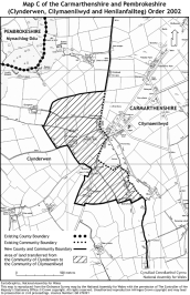
The part of the community of Clynderwen shown hatched in black on boundary map C is separated from that community and forms part of the community of Cilymaenllwyd in Carmarthenshire;
(4)
The part of the community of Henllanfallteg in Carmarthenshire shown hatched in black on boundary map D is separated from that community and forms part of the community of Clynderwen.
(5)
The part of the community of Clynderwen in Pembrokeshire shown hatched in black on boundary map E is separated from that community and forms part of the community of Henllanfallteg in Carmarthenshire.
Signed on behalf of the National Assembly for Wales


This Order, made in accordance with section 58(2) of the Local Government Act 1972, gives effect with modifications to proposals by the Local Government Boundary Commission for Wales. The effect of those modified proposals is that on the coming into force of this Order:
the community of Clynderwen (shown hatched in black on boundary map A referred to in Article 2 of the Order) will be transferred from Carmarthenshire and become part of Pembrokeshire.
the area which is part of the community of Cilymaenllwyd in Carmarthenshire (including land and property known as “Troed y Rhiw”) (shown hatched in black on boundary map B referred to in Article 2 of the Order) will become part of the community of Clynderwen in Pembrokeshire;
the area which is part of the community of Clynderwen (shown hatched in black on boundary map C referred to in Article 2 of the Order) will become part of the community of Cilymaenllwyd in Carmarthenshire;
the area which is part of the community of Henllanfallteg in Carmarthenshire (shown hatched in black on boundary map D referred to in Article 2 of the Order) will become part of the community of Clynderwen in Pembrokeshire.
the area which is part of the community of Clynderwen in Carmarthenshire in the vicinity of Pen-deri Farm (shown hatched in black on boundary map E referred to in Article 2 of the Order) and which does not include any dwellings will become part of the community of Henllanfallteg in Pembrokeshire so that the boundary in that area will follow the centre of the Afon Daulan.
Prints of the boundary maps are deposited and may be inspected during normal office hours at the offices of Carmarthenshire County Council at County Hall, Carmarthen, Pembrokeshire County Council at County Hall, Haverfordwest and at the offices of the National Assembly for Wales at Cathays Park, Cardiff (Local Government Modernisation Division).
The Local Government Area Changes Regulations 1976 (as amended) referred to in Article 2 of this Order contain incidental, consequential, transitional and supplementary provisions about the effect and implementation of orders such as this.