Statutory Instruments
2010 No. 1508
Highways, England
The Council of the City of York (Hungate Bridge) Scheme 2009 Confirmation Instrument 2010
Made
24th May 2010
Coming into force in accordance with article 1
1. This Instrument may be cited as “The Council of the City of York (Hungate Bridge) Scheme 2009 Confirmation Instrument 2010” and shall come into force on the date on which notice that it has been confirmed is first published in accordance with paragraph 1 of Schedule 2 to the Highways Act 1980.
2. The Council of the City of York (Hungate Bridge) Scheme 2009 (“the Scheme”) is hereby confirmed without modifications.
3. The Scheme as confirmed is set out in the Schedule hereto (including the plans) and copies of the Scheme as modified with its accompanying plans are deposited at the offices of the Department for Transport, Floor 13 (IMD), Ashdown House, St Leonards on Sea, Hastings, East Sussex, TN37 7GA, and at the offices of the Guildhall, York, YO1 9QN.
Signed by authority of the Secretary of State for Transport
J Blackie
Regional Director
Government Office for the North East
24th May 2010
THE SCHEDULE
The Council of the City of York (hereinafter referred to as “the Council”) makes this Scheme in exercise of its powers under Section 106(3) of the Highways Act 1980.
1. The Council is authorised to construct over the navigable waters of the River Foss the bridge specified in the Schedule to this Scheme as part of the highway which it is proposing to construct between Navigation Road and the Hungate Development in the said City.
2. The Scheme may be cited as the Council of the City of York (Hungate Bridge) Scheme 2009.
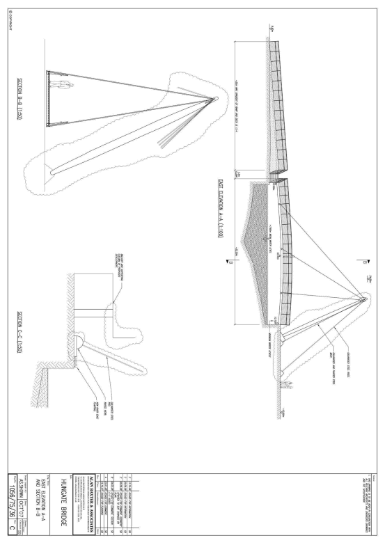
THE SCHEDULE TO THE SCHEMEPLANS AND SPECIFICATIONS OF THE SCALE LANE BRIDGE
The location and general design of the Bridge are shown on the plans numbered 1056/75/35 Rev E, 1056/75/36 Rev C, 1056/75/38 and the contextual drawing all marked “The Council of the City of York (Hungate Bridge) Scheme 2009” sealed with the Common Seal of the Council and deposited at The Guildhall, York, YO1 9QN (the offices of the Council) and of the Secretary of State for Transport.
Points of Commencement and Termination
From the projected northern highway boundary line of Navigation Road, at a central longitudinal point 4.5 metres from the western property boundary of Corporation Yard, north to its central longitudinal terminal point on the northern bank of the River Foss 8.5 metres west from the said projected western property boundary as shown on plan 1056/75/35 Rev E.
Span
A single span of approximately 47 metres.
Headway
Not less than 2.4 metres above the mean water level (MWL) of 7.6 metres AOD, with a maximum headway of 3.1 metres above the aforementioned mean water level (MWL) at the centre of the navigation channel.
Waterway
A minimum clear navigable waterway of 20 metres.
Overall Dimensions
The Bridge will be of an approximate overall width of 4.4 over the navigation channel and will carry a shared footway/cycleway of 4 metre.


EXPLANATORY NOTE
(This note is not part of the Instrument)
This instrument confirms a scheme to construct over the navigable waters of the River Foss a bridge as part of the highway which it is proposing to construct between Navigation Road and the Hungate Development, York.
A regulatory impact assessment has not been produced for this instrument as it has no significant impact on business, charities or voluntary bodies.