- Latest available (Revised)
- Original (As made)
The Surrey County Council (New Thames Road Bridge, Walton) Scheme 2008 Confirmation Instrument 2009
You are here:
- UK Statutory Instruments
- 2009 No. 3405
- SCHEDULE TO THE SCHEME

What Version
More Resources
Status:
This is the original version (as it was originally made). This item of legislation is currently only available in its original format.
SCHEDULE TO THE SCHEME
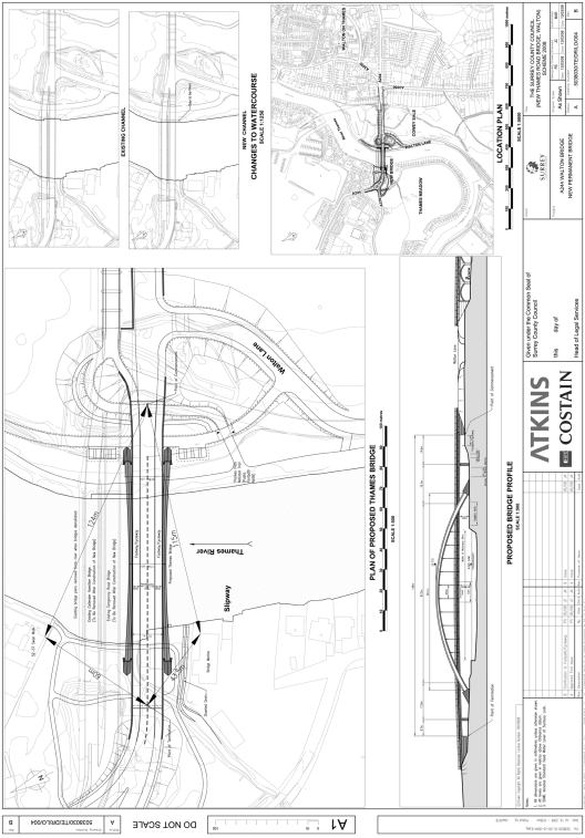
PLAN AND SPECIFICATIONS OF THE NEW THAMES ROAD BRIDGE, WALTON
The location and general design of the bridge are shown on the plan numbered 5038030/TE/DR/LO/004 Rev B, annexed hereto.
POINT OF COMMENCEMENT AND TERMINATION
The points of commencement and termination are dimensioned from the north eastern corner of the building known as Bridge Marine and the southern corner of nos. 52 to 57 Swan Walk. Bridge Marine is located on the west bank of the river approximately 40 metres upstream of the existing temporary road bridge over the Thames. Nos. 52 to 57 Swan Walk are located on the west bank of the river approximately 20 metres downstream of the existing Callender-Hamilton Bridge over the Thames (pedestrians, cyclists and authorised maintenance vehicles only).
a)Point of Commencement
From a point on the east bank of the River Thames 124m metres from the southern corner of Nos. 52 to 57 Swan Walk and 115 metres from the north eastern corner of Bridge Marine.
b)Point of Termination
To a point on the west bank of the River Thames 60 metres from the southern corner of Nos. 52 to 57 Swan Walk and 43.5 metres from the north eastern corner of Bridge Marine.
SPANS
The main supporting arch spans 96.1 metres to the centreline of steel arch ribs and crosses the River Thames, the Thames Path National Trail and both west and east banks of the River Thames. The bridge deck is supported at abutments, at intermediate piers, and by the arch with hangers attached to the arches. Proceeding from the east bank these spans are 14.9 metres, 19.1 metres, 87.5 metres, 17.8 metres and 8.7 metres respectively.
HEADWAY
The headway above standard head water level (standard head water level for the Sunbury reach of the Thames is 8.095 metres above Ordnance Datum) will vary over the width of the river. A minimum headway of 6 metres will be provided over the main navigable channel which is 10 metres wide and centred about the centreline of the arches.
WATERWAY
A minimum clear navigable waterway of 64 metres.
OVERALL DIMENSIONS
The overall length of the bridge will be 148 metres. The new bridge will carry a 7.3 metre carriageway with a 3.5 metre shared footways/cycleways on each side. The overall width of the bridge deck will be 15.3 metres. The overall width including the arch members varies from 21.85 metres at the arch springing to 17.4 metres at the centre of the arch.
Options/Help
Print Options
PrintThe Whole Instrument
PrintThis Schedule only

Legislation is available in different versions:
Latest Available (revised):The latest available updated version of the legislation incorporating changes made by subsequent legislation and applied by our editorial team. Changes we have not yet applied to the text, can be found in the ‘Changes to Legislation’ area.
Original (As Enacted or Made): The original version of the legislation as it stood when it was enacted or made. No changes have been applied to the text.
Opening Options
Different options to open legislation in order to view more content on screen at once
More Resources
Access essential accompanying documents and information for this legislation item from this tab. Dependent on the legislation item being viewed this may include:
- the original print PDF of the as enacted version that was used for the print copy
- lists of changes made by and/or affecting this legislation item
- confers power and blanket amendment details
- all formats of all associated documents
- correction slips
- links to related legislation and further information resources
More Resources
Use this menu to access essential accompanying documents and information for this legislation item. Dependent on the legislation item being viewed this may include:
- the original print PDF of the as made version that was used for the print copy
- correction slips
Click 'View More' or select 'More Resources' tab for additional information including:
- lists of changes made by and/or affecting this legislation item
- confers power and blanket amendment details
- all formats of all associated documents
- links to related legislation and further information resources
 All content is available under the Open Government Licence v3.0 except where otherwise stated. This site additionally contains content derived from EUR-Lex, reused under the terms of the Commission Decision 2011/833/EU on the reuse of documents from the EU institutions. For more information see the EUR-Lex public statement on re-use.