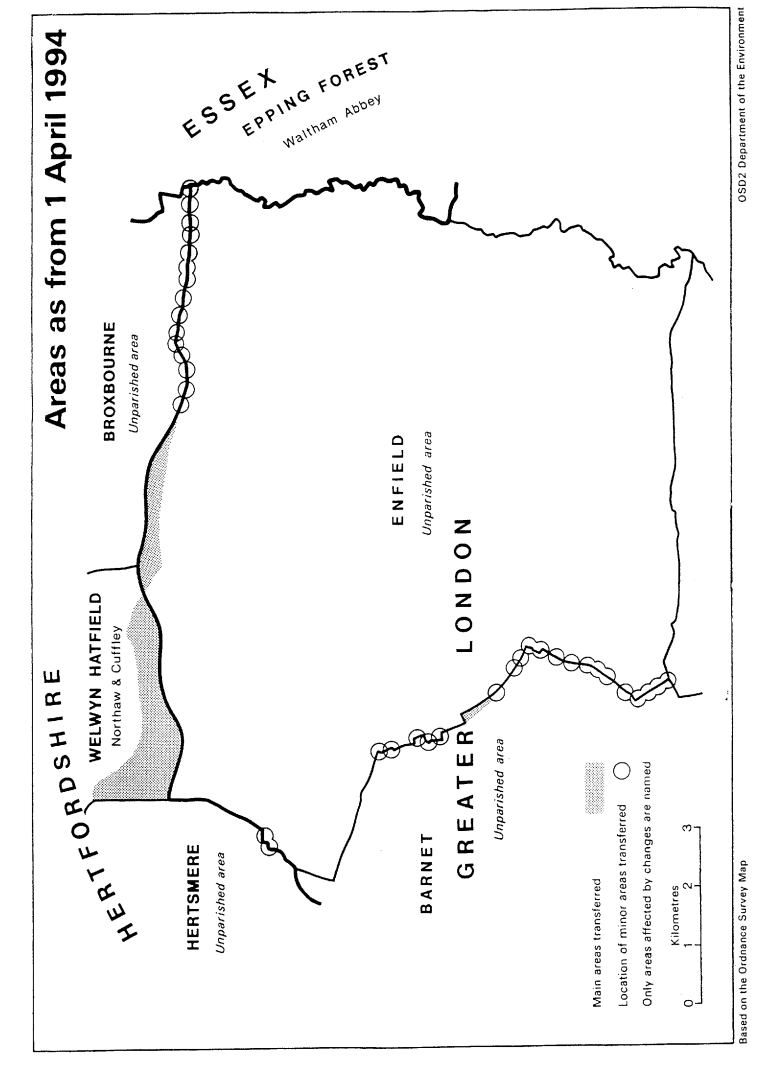
This Order makes mainly minor changes to the boundary of the London borough of Enfield with–
Hertfordshire (districts of Broxbourne, Hertsmere and Welwyn Hatfield);
Essex (district of Epping Forest); and
the London borough of Barnet. Consequential changes are made to the boundaries of parishes, local government electoral areas, petty sessional divisions and coroners' districts.
The map and table forming part of this Note (Pages 5 to 7) give a general guide to the location, area and population of the land affected. Prints of the detailed order maps (described in article 2) may be inspected at all reasonable times at the offices of the council for each borough or district affected, and additionally at the offices of the Secretary of State for the Environment located in 2, Marsham Street, London SW1P 3EB.
The Local Government Area Changes Regulations 1976 (S.I. 1976/246, Amended by S.I. 1978/247) contain general provisions regarding the effect of orders such as this one.
Transfers– | Description– |
|---|---|
In Articles 3 and 4 Between Greater London (Enfield) and Hertfordshire (Broxbourne, Hertsmere and Welwyn Hatfield) Transferred from Enfield– Area: 220 hectares Population: 30 Transferred to Enfield– Area: 84 hectares Population: 34 | Realignment of Broxbourne/Enfield boundary to northern side of M25 motorway at the following locations– The Paddocks/Burntfarm Ride/north of Glasgow Stud and Whitewebbs Farm/south of western Jewish Cemetery and County Brook Plantation/at Great Cambridge Road roundabout/Holmesdale Tunnel/Hertford Road/Britannia Business Park/south of New Ford Road. Transfer to Welwyn Hatfield of area north of M25 motorway and south of Coopers Lane Road, and lying between the Welwyn/Hertsmere boundary in the west and Cattlegate Farm in the east. Properties transferred include Chequers Mead, Woodhurst, Woodhurst Farm Cottage, Woodhurst Farm and part of Cattlegate Farm. Transfer to unite properties in Waggon Road in Enfield. |
In Article 5 Between Greater London (Enfield) and Essex (Epping Forest) Transferred from Enfield– Area: 0.25 hectare Population: Nil Transferred to Enfield– Area: 700 square metres Population: Nil | Minor realignments in the vicinity of the River Lee Navigation at Rammey Marsh. |
In Article 6Between the London boroughs of Barnet and Enfield | Transfer to Barnet of area in Mount Pleasant/Ashhurst Road. Transfer to Barnet of area on western side of Chase Side south of Oaktree School. |
Transferred from Enfield– Area: 10 hectares Population: 232 | Realignments in the following locations–
|
Transferred to Enfield– Area: 8 hectares Population: 112 | Station/Friern Barnet Road/Bowes Road;
|