The Cheshire and Greater Manchester (County and District Boundaries) (No. 2) Order 1992
Citation and commencement1.
(1)
This Order may be cited as the Cheshire and Greater Manchester (County and District Boundaries) (No. 2) Order 1992.
(2)
(3)
For all other purposes, this Order shall come into force on 1st April 1993.
Interpretation2.
In this Order—
“Cheshire” means the county of Cheshire, and “Macclesfield” means the borough of Macclesfield in that county;
“electoral division” means an electoral division of Cheshire;
“Greater Manchester” means the metropolitan county of Greater Manchester, “Manchester” means the city of Manchester, “Salford” the city of Salford, “Stockport” the metropolitan borough of Stockport, and “Tameside” the metropoli tan borough of Tameside, all of which are located in that county;
“the map” means one or more of the 21 maps prepared by the Department of the Environment, marked “Maps of the Cheshire and Greater Manchester (County and District Boundaries) (No. 2) Order 1992”, and deposited in accordance with regulation 5 of the Local Government Area Changes Regulations 1976;
any reference to an area as unparished is a reference to that area not forming part of any parish; and
“ward” means a ward of the borough, city or metropolitan borough from or to which an area is transferred.
Transfers from Cheshire (Macclesfield) to Greater Manchester (Manchester)3.
Each area described in column 1 of the following Table shall be transferred from Cheshire and from Macclesfield to—
(a)
Greater Manchester;
(b)
Manchester;
(c)
the parish (if any) named in column 2;
(d)
the Woodhouse Park ward; and to
(e)
the Manchester petty sessional division and the Manchester coroner’s district.
(1) | (2) |
|---|---|
Description of area transferred from Cheshire and from Macclesfield— | Transfered to Greater Manchester, to Manchester and to parish of— |
The unparished area of the Morley and Styal ward which is marked A on map 17. | Unparished |
The unparished area of Morley and Styal ward which is marked B on map 17. | Ringway |
The parts of the parish of Ashley marked A to K (inclusive) on map 18. | Ringway |
The parts of the parish of Mobberley marked V, W and X on map 18. | Ringway |
Transfers from Greater Manchester (Manchester) to Cheshire (Macclesfield)4.
Each area which is described in column 1 of the following Table shall be transferred from Greater Manchester and from Manchester to—
(a)
Cheshire;
(b)
Macclesfield;
(c)
the parish (if any), ward and the electoral division mentioned in column 2; and to
(d)
the Macclesfield petty sessional division and the Cheshire coroner’s district.
Description of area— | Transferred to Cheshire, to Macclesfield, and to— |
|---|---|
The unparished area of Woodhouse Park ward marked C on map 16. | Unparished Morley and Styal ward Wimslow Bollin electoral division |
The part of the parish of Ringway marked C on map 17. | Unparished Morley and Styal ward Wimslow Bollin electoral division |
The parts of the parish of Ringway marked L to U ward (inclusive) on map 18. | Parish of Ashley Mere ward Bucklow electoral division |
The parts of the parish of Ringway marked Y, Z and AA on map 18. | Parish of Mobberley Mobberley ward Bucklow electoral division |
Transfers within Greater Manchester between Manchester and Salford5.
(1)
Each area which is marked as shown in column 1 of the following Table on the map indicated in column 2 shall be transferred from Manchester, and from the Cheetham ward to Salford, to the ward named in column 3, and to the Salford petty sessional division and the Greater Manchester West coroner’s district, remaining unparished.
(1) | (2) | (3) |
|---|---|---|
Area marked | On map— | Transferred to Salford and to the following ward— |
G and I | 19 | Blackfriars |
A and D | 19 | Broughton |
C | 20 | |
A | 20 | Kersal |
(2)
Each area marked as shown in column 1 of the following Table on the map indicated in column 2 shall be transferred from Salford, and from the ward named in column 3 to Manchester, to the ward mentioned in column 4, and to the Manchester petty sessional division and the Manchester coroner’s district, remaining unparished.
(1) | (2) | (3) | (4) |
|---|---|---|---|
Area marked | On map— | Transferred from Salford, and from the following ward— | To Manchester, and to the following ward— |
F, H and J | 19 | Blackfriars | Cheetham |
B, C and E | 19 | Broughton | Cheetham |
B | 20 | ||
A | 21 | Kersal | Crumpsall |
Transfers within Greater Manchester between Manchester and Stockport6.
(1)
Each area which is marked as shown in column 1 of the following table on the map indicated in column 2 shall be transferred from Manchester, and from the ward named in column 3 to Stockport, to the ward named in column 4, and to the Stockport petty sessional division, and the Greater Manchester South coroner’s district, remaining unparished.
(1) | (2) | (3) | (4) |
|---|---|---|---|
Area marked | On map | Transferred from Manchester, and from the following ward— | To Stockport, and to the following ward— |
A | 12 | Burnage | Heaton Mersey |
A, C, D and E | 11 | Burnage | Heaton Moor |
B | 14 | Didsbury | Cheadle |
A | 13 | Didsbury | Heaton Mersey |
A and C | 7 | Gorton North | North Reddish |
B | 8 | Gorton South | North Reddish |
A | 9 | Levenshulme | South Reddish |
A | 15 | Sharston | Cheadle |
B | 16 | Woodhouse Park | Heald Green |
(2)
Each area which is marked as shown in column 1 of the following Table on the map indicated in column 2 shall be transferred from Stockport, and from the ward named in column 3 to Manchester, to the ward named in column 4, and to the Manchester petty sessional division and the Manchester coroner’s district, remaining unparished.
(1) | (2) | (3) | (4) |
|---|---|---|---|
Area marked | On map | Transferred from Stockport, and from the following ward | To Manchester, and to the following ward |
A | 14 | Cheadle | Didsbury |
A | 16 | Heald Green | Woodhouse Park |
B | 13 | Heaton Mersey | Didsbury |
B | 11 | Heaton Moor | Burnage |
B | 12 | ||
A | 10 | Heaton Moor | Levenshulme |
B and D | 7 | North Reddish | Gorton North |
A | 8 | North Reddish | Gorton South |
(3)
In consequence of the transfers effected by paragraphs (1) and (2), the wards of Stockport shall be altered by the transfer of the area marked C on map 12 from Heaton Moor ward to Heaton Mersey ward.
Transfers within Greater Manchester between Manchester and Tameside7.
(1)
Each area which is marked as shown in column 1 of the following Table on the map indicated in column 2 shall be transferred from Manchester, and from the ward named in column 3 to Tameside, to the ward mentioned in column 4 and to the Ashton- under-Lyne petty sessional division and the Greater Manchester South coroner’s district.
(1) | (2) | (3) | (4) |
|---|---|---|---|
Area marked | On map | Transferred from Manchester, and from the following ward— | To Tameside, and to the following ward— |
B | 2 | Beswick and Clayton | Droylsden East |
B | 1 | Beswick and Clayton | Droylsden West |
A | 2 | ||
A | 5 | Bradford | Audenshaw |
B | 3 | Bradford | Droylsden East |
B | 4 | ||
B | 5 | ||
A & C | 6 | Gorton North | Denton West |
(2)
Each area which is marked as shown in column 1 of the following Table on the map indicated in column 2 shall be transferred from Tameside, and from the ward named in column 3 to Manchester, to the ward mentioned in column 4 and to the Manchester petty sessional division and the Manchester coroner’s district.
(1) | (2) | (3) | (4) |
|---|---|---|---|
Area marked— | On map— | Transferred from Tameside, and from the following ward— | To Manchester, and to the following ward— |
B | 6 | Denton West | Gorton North |
C | 2 | Droylsden East | Beswick and Clayton |
A | 3 | Droylsden East | Bradford |
A | 4 | ||
A, C & D | 1 | Droylsden West | Beswick and Clayton |
Town and country planning8.
(1)
(2)
Any provision applying to an area transferred by this Order shall continue to apply to that area, notwithstanding the transfer, until replaced by a provision which so applies, and which is expressed to supersede the preserved provision.
Signed by authority of the Secretary of State for the Environment
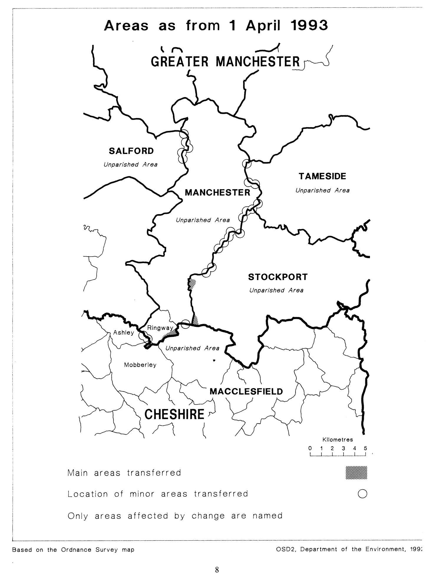
This Order makes changes in the boundary between the county of Cheshire and the metropolitan county of Greater Manchester, affecting the Cheshire borough of Macclesfield and the city of Manchester. It also affects district boundaries within Greater Manchester by transferring areas between the city of Manchester and each of the following—
the city of Salford, the metropolitan borough of Stockport, the metropolitan borough of Tameside.
Consequential changes to local government electoral areas, petty sessional divisions and coroners' districts are made.
The map and table forming part of this Note are a general guide only to the areas affected. The table gives in approximate terms the total area of land and the population affected by each set of transfers. The maps described in article 2 should be inspected for full details of the transfers. Any person may inspect the maps at any reasonable time at the offices of each borough or city whose area is affected, and additionally at the offices of the Secretary of State for the Environment located in 2, Marsham Street, London SW1P 3EB.
The Local Government Area Changes Regulations 1976 contain general provisions regarding the effect of orders such as this one.
Transfers between— | General description of main changes |
|---|---|
Cheshire (Macclesfield) and Greater Manchester (Manchester) Articles 3 and 4 Total area: 4 hectares Population: 1 | Changes in the vicinity of Manchester Airport to unite its operational area and land at the south west end of the runway in Manchester. Transfer to Macclesfield of land at Boundary Farm, Moss Nook. Realignment of boundary to centre of the River Bollin in area stretching from the Airport to Sunbank Wood. |
Manchester and Salford Article 5 Total area: 2 hectares Population: 400 | Transfer to Salford in vicinity of Ramsgate Street, Rugby Street and Cambridge Street, including part of Broughton Lane. Transfer to Salford of area off Bury Old Road, running south west along St. Mark’s Lane to Tetlow Lane. Transfer to Manchester of residential area bounded in the north by north Clifden Lane, Pembroke Street, James Road and Marlborough Road. Transfer to Manchester of area located north of Bury Old Road and south of Catherine Road, including part of Berkeley Court. Realignments in the following areas — Edward Street/Overbridge Road, Bury New Road/Appian Way, Highclere Avenue/Dudley Street, Great Cheetham Street East/Orient Street, Dorothy Street/Marsland Street/Winterford Avenue. |
Manchester and Stockport Article 6 Total area: 45 hectares Population: 2,240 | Transfer to Stockport of part of Marbury Road and area including Simon Freeman Close. Transfer to Stockport of part of Green Pastures in the Didsbury Road area. Transfer to Stockport of large residential area at Gatley, bounded by the M56 in the north, Hollyhedge Park in the west, Gatley Brook in the east, and terminating in the south on Styal Road in the vicinity of South Drive. Transfer to Stockport of area east of railway line near Moss Nook, including Wood Farm. Transfer to Manchester of area west of railway line and north of Sandfold Lane, including parts of school sites and railway depot. Transfer to Manchester of part of Cringle Fields Park north of Crossley Road. Transfer to Manchester of area south of Kingsleigh Road. Transfer to Manchester of part of playing fields south of Royal Ford Hall, East Didsbury. |
Manchester and Tameside Article 7 Area: 1 hectare Population: 90 | Transfer to Tameside of—
Transfer to Manchester of—
Minor realignments in the following areas— Edge Lane/Salcombe Road; Peel Street Telephone Exchange; junction of Kingsdale Road with Manchester Road; and Bristowe Road, in vicinity of North road and Trenchard Court. |