Statutory Instruments
1992 No. 2090
LOCAL GOVERNMENT, ENGLAND AND WALES
CHANGES IN LOCAL GOVERNMENT AREAS
The Greater London and Kent (County Boundaries) Order 1992
Made
31st August 1992
Laid before Parliament
9th September 1992
Coming into force
for the purposes referred to in article 1(2)
30th September 1992
all other purposes
1st April 1993
The Secretary of State, in exercise of his powers under sections 51(2) and 67(4) of the Local Government Act 1972(1) and of all other powers enabling him in that behalf, hereby makes the following Order which gives effect, with modifications, to proposals submitted to him under sections 47, 48(1) and 51(1) of that Act, more than six weeks before the making of this Order, by the Local Government Boundary Commission for England:
Citation and commencement
1.—(1) This Order may be cited as the Greater London and Kent (County Boundaries) Order 1992.
(2) This Order shall come into force on 30th September 1992 for any purpose set out in regulation 4(1) of the Local Government Area Changes Regulations 1976(2).
(3) For all other purposes, this Order shall come into force on 1st April 1993.
Interpretation
2. In this Order—
“Bexley” means the London borough of Bexley;
“Kent” means the county of Kent;
“Dartford” means the borough of Dartford in that county; and
“electoral division” means an electoral division of that county,
“the map” means one of the 4 maps prepared by the Department of the Environment, marked “Maps of the Greater London and Kent (County Boundaries) Order 1922”, and deposited in accordance with regulation 5 of the Local Government Area Changes Regulations 1976; and
“ward” means a ward of the borough from or to which an area is transferred.
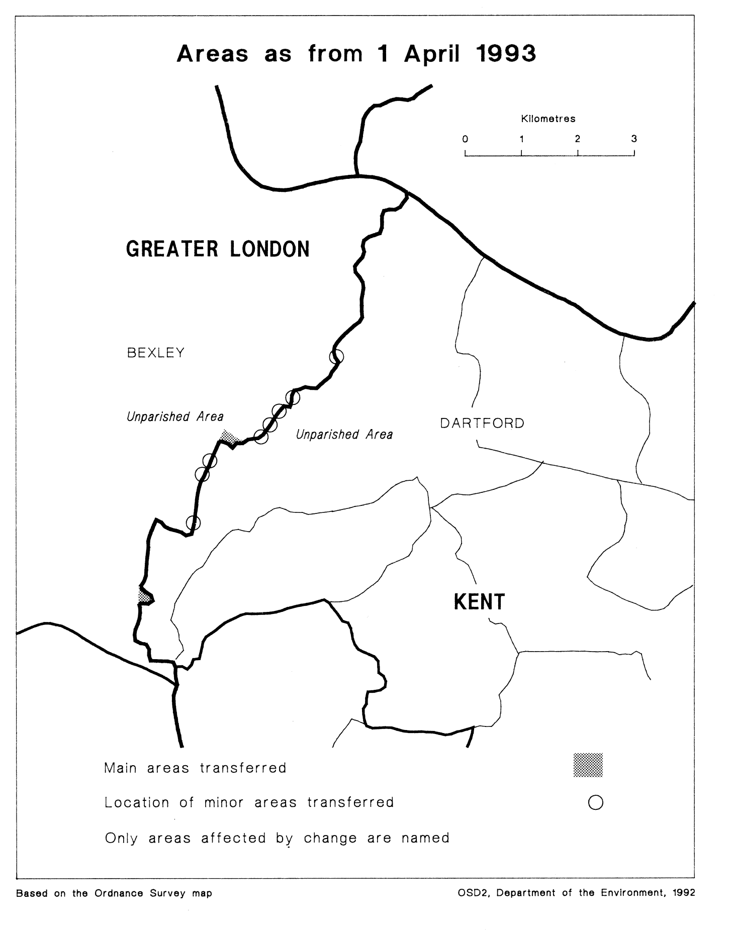
Transfers from Greater London (Bexley) to Kent (Dartford)
3. Each area which is marked as shown in column 1 of the following Table on the map indicated in column 2 shall be transferred from Greater London, from Bexley, and from the ward mentioned in column 3 to—
(a)Kent;
(b)Dartford;
(c)the ward and the electoral division mentioned in column 4; and to
(d)the Dartford petty sessional division and the North Kent coroner’s district.
TABLE
| (1) | (2) | (3) | (4) |
|---|---|---|---|
| Area marked | On map | Transferred from Greater London, from Bexley, and from— | To Kent, to Dartford, and to— |
| B3 | 3 | Crayford ward | Gundulf ward Dartford West electoral divison |
| 3 | B4 and B6 | Crayford ward | Heath ward Dartford West electoral division |
| B1 | 1 | North End ward | Priory ward Dartford ward West electoral division |
| B11 | 3 | St. Mary’s ward | Maypole ward Dartford ward West electoral division |
| B9 and B10 | 3 | Upton ward | Heath ward Dartford West electoral division |
Transfers from Kent (Dartford) to Greater London (Bexley)
4. Each area which is marked as shown in column 1 of the following Table on the map indicated in column 2 shall be transferred from Kent, from Dartford and from the ward mentioned in column 3 to—
(a)Greater London;
(b)Bexley;
(c)the ward mentioned in column 4; and to
(d)the Bexley petty sessional division, and the Southern London coroner’s district.
TABLE
| (1) | (2) | (3) | (4) |
|---|---|---|---|
| Area marked | On map | Transferred from Kent, from Dartford and from— | To Greater London, to Bexley, and to— |
| B5 and B7 | 3 | Heath ward | Crayford ward |
| B8 | 3 | Heath ward | Upton ward |
| B2 | 2 | Maypole ward | Cray ward |
| B12 | 4 | Maypole ward | St. Mary’s ward |
Town and country planning
5.—(1) In this article, “provision” means a provision of a development plan (as defined in section 336 of the Town and Country Planning Act 1990(3)).
(2) Any provision applying to an area transferred by this Order shall continue to apply to that area, notwithstanding the transfer, until replaced by a provision which so applies, and which is expressed to supersede the preserved provision.
Signed by authority of theSecretary of State for the Environment
G. S. K. Young
Minister of State,
Department of the Environment
31st August 1992
Explanatory Note
(This note is not part of the Order)
This Order transfers areas between Greater London and Kent, affecting the boundaries of the London borough of Bexley, and of the Kent borough of Dartford. Consequential local government electoral areas, petty sessional divisions and coroners' districts are made.
The map and table forming part of this note (Pages 5 and 6) give a general guide to the areas transferred. In approximate terms, the total area of land transferred from Greater London to Kent is 15 hectares (population of 30), and that transferred from Kent to Greater London, 5 hectares (population of 70). Prints of the detailed maps (described in article 2) may be inspected at all reasonable times at the offices of the council for each borough affected, and additionally at the offices of the Secretary of State for the Environment located in 2, Marsham Street, London SW1P 3EB.
The Local Government Area Changes Regulations 1976 contain general provisions regarding the effect of orders such as this one.
TABLE
| Main transfer from Greater London (Bexley) to Kent (Dartford) | Area of open land in the vicinity of the River Cray/Stanham River/Thames Road, lying to the east of the depot. |
|---|---|
| Main transfers from Kent (Dartford) to Greater London (Bexley) | 1. Area of open land west of Hillcrest Road and north of Rochester Way, including the site of the former Gun Club. 2. Transfer of area of woodland at Joyden’s Wood/Chalk Wood. 3. Transfer of residential area, affecting Tile Kiln Lane, Wicksteed Close and Staple Close, and open land to the south of Staple Close. |
| Minor realignments in the following areas— | 1. Maiden Lane/Crayford Road/North Road/Chastilian Road. 2. In vicinity of East Rochester Way and Denton Road. |
1990 c. 8. This definition was amended by the Planning and Compensation Act 1991 (c. 34), Schedule 4, paragraph 34.