SCHEDULE 1MAP
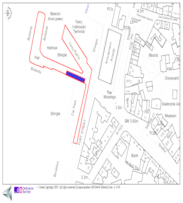
SCHEDULE 2HARBOUR LIMITS
An area within Largs Bay and Castle Bay enclosed on its seaward sides by imaginary lines–
from a point in Noddsdale Water at reference point NS 19889, 60421 in an westerly direction to reference point NS 19444, 60421; thence in a generally southerly direction following an irregular line 400 yards from the level of high water to reference point NS 19957, 58455; thence in an easterly direction to reference point NS 20540, 58455; and on its landward sides by the level of high water within the area so enclosed.
SCHEDULE 3WORKS
Work No 1
Demolition of the existing masonry pier to a level of 4 metres below Chart Datum commencing at reference point NS 20039 59493 and terminating at reference point NS 20048 59537.
Work No 2
A new pier of solid construction comprising steel sheet piled walls with a concrete deck the centre line of which commences at reference point NS 20080 59472 and extends at a deck width of some 15.5 metres in a west north westerly direction for a distance of 71 metres or thereby thence at a deck width of some 13.2 metres in a north north–easterly direction for a distance of 73 or thereby metres and terminating at reference point NS 20038 59553.
Work No 3
Dredging of the sea bed to a level of 4 metres below Chart Datum with side slopes at a gradient of 1 vertical to 6 horizontal within the shaded area shown on Sheet 4 of the deposited plans.
Work No 4
Rock armour to the side slopes of the dredged area of Work No 3 to protect the existing shore commencing at reference point NS 20077 59435 and terminating at reference point NS 20060 59440.
Work No 5
Rock armour to the side slopes of the dredged area of Work No 3 to protect the existing shore commencing at reference point NS 20093 59480 and terminating at reference point NS 20084 59490.
Work No 6
Rock armour to the side slopes of the dredged area of Work No 3 to protect the existing shore commencing at reference point NS 20114 59545 and terminating at reference point NS 20098 59536.
Work No 7
Steel sheet piling around the outside of the existing slip to protect the slip against scour following the dredging of Work No 3 which commences at reference point NS 20104 59482 and extends in a north westerly direction for a distance of 14 metres to reference point 20094 59493 thence in a north easterly direction for a distance of 15 metres to reference point 200106 59502 thence in a south easterly direction for a distance of 11 metres terminating at reference point NS 20113 59494.
SCHEDULE 4ENACTMENTS REPEALED
Chapter | Short Title | Extent of Repeal |
|---|---|---|
Largs Harbour Act 1832 | The whole Act except sections 1 to 5 and 24 | |
Glasgow and South Western Railway Act 1899 | Sections 34 36 | |
London Midland and Scottish Railway Order Confirmation Act 1933 | In the First Schedule to the London Midland and Scottish Railway Order 1933 the words “Largs Harbour Act 1832” and the whole of the Ninth Schedule to said Order |