Statutory Instruments
1993 No. 1417
LOCAL GOVERNMENT, ENGLAND AND WALES
CHANGES IN LOCAL GOVERNMENT AREAS
The Hackney, Haringey and Islington (London Borough Boundaries) Order 1993
Made
27th May 1993
Laid before Parliament
11th June 1993
Coming into force
for the purposes referred to in article 1(2)
1st December 1993
for all other purposes
1st April 1994
The Secretary of State, in exercise of his powers under sections 51(2) and 67(4) of the Local Government Act 1972(1) and of all other powers enabling him in that behalf, hereby makes the following Order which gives effect with modifications to proposals submitted to him under sections 47, 48(1) and 51(1) of that Act, more than six weeks before the making of this Order, by the Local Government Boundary Commission for England:
Citation and commencement
1.—(1) This Order may be cited as the Hackney, Haringey and Islington (London Borough Boundaries) Order 1993.
(2) This Order shall come into force on 1st December 1993 for any purpose set out in regulation 4(1) of the Local Government Area Changes Regulations 1976(2).
(3) For all other purposes, this Order shall come into force on 1st April 1994.
Interpretation
2. In this Orderany reference to Hackney, to Haringey or to Islington is a reference to the London borough of that name;
“the map” means one of the 5 maps prepared by the Department of the Environment, marked “Maps of the Hackney, Haringey and Islington (London Borough Boundaries) Order 1993”, and deposited in accordance with regulation 5 of the Local Government Area Changes Regulations 1976;
and any reference to a ward is a reference to a ward of the London borough from or to which an area is transferred.
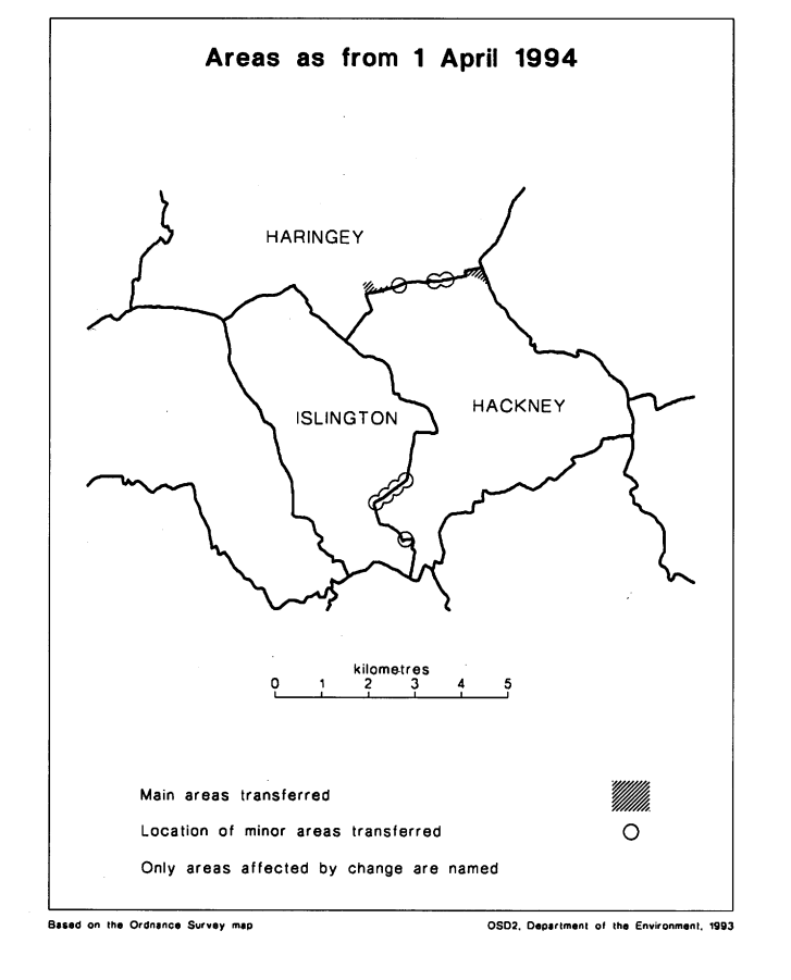
Transfers between Hackney and Haringey
3.—(1) The following areas of Hackney
(i)the part of the New River ward marked A on map 3; and
(ii)the part of the Northfield ward marked A on map 4
shall be transferred to Haringey, to the Seven Sisters ward, to the Enfield petty sessional area, and to the Northern London coroner’s district.
(2) The following areas of Haringey
(i)the part of the Seven Sisters ward marked B and C on map 4; and
(ii)the part of the South Tottenham ward marked A on map 5
shall be transferred to Hackney, to the East Central petty sessional area and to the Inner North London coroner’s district. The area marked B and C on map 4 shall additionally be transferred to the Northfield ward, and the area marked A on map 5 to the Springfield ward.
Transfers between Hackney and Islington
4.—(1) The area marked A on map 2 shall be transferred from Islington, and from the St Peter ward to Hackney and to the Wenlock ward.
(2) Each area which is described in column 1 of the following Table shall be transferred from Hackney to Islington, to the ward named in column 2.
TABLE
| Transferred from Hackney— | To Islington, and to the following ward— |
|---|---|
| The part of the Moorfields ward marked A on map 1 | Bunhill |
| The part of the Wenlock ward marked D on map 2 | Canonbury East |
| The part of the Wenlock ward marked B and C on map 2 | St Peter |
Town and Country Planning
5.—(1) In this article, “provision” means a provision of a development plan (as defined in section 336(1) of the Town and Country Planning Act 1990(3)).
(2) Any provision applying to an area transferred by this Order shall continue to apply to that area, notwithstanding the transfer, until replaced by a provision which so applies, and which is expressed to supersede the preserved provision.
Signed by authority of the Secretary of State
Robin Squire
Parliamentary Under Secretary of State,
Department of the Environment
27th May 1993
Explanatory Note
(This note is not part of the Order)
This Order makes changes within Greater London to the boundary between London borough of Hackney and the London boroughs of Haringey and Islington.
Consequential changes are made to the boundaries of borough wards, petty sessional areas and coroner’s districts.
No parishes are affected.
The map and table forming part of this Note (Page 4) give a general guide to the areas involved, the changes made and the approximate total hectarage and population affected by each set of transfers.
For full details of the transfers made, the order maps (described in article 2) should be inspected.
Any person may inspect them at any reasonable time at the offices of the council for each London borough affected, and also at the offices of the Secretary of State for the Environment located in 2, Marsham Street, London SW1P 3EB.
The Local Government Area Changes Regulations 1976 (S. I. 1976/246, amended by S. I. 1978/247) contain general provisions regarding the effect of orders such as this one.
TABLE
| Transfers between— | Description of changes— |
|---|---|
| Hackney and Haringey Article 3 Transferred from Hackney— Area: 6 hectares Population: 400 Transferred to Hackney— Area: 4.5 hectares Population: 500 | Transfer to Hackney of area lying between railway line north of Stamford Hill Station and the A10 road at Stamford Hill, affecting Hillside Road, Northdene Gardens and the area north of Margetson House. Realignment to centre of New River between Green Lanes and Seven Sisters Road, transferring to Haringey properties in Hermitage Road, Green Lanes and their vicinity. Transfer to unite Vartry Road in Haringey by realigning boundary to centre of the railway line north of Stamford Hill Station. Transfer to Hackney of area bounded by rear curtilages of properties in Moundfield Road in the west, the centre of the river Lea in the east, and the southern side of Craven Park Road in the north. The effect of this transfer is to unite Moundfield Road, Castlewood Road, Craven Park Primary School, Leadale Road, Timberwharf Road, Maple Close, Fairweather Wharf, Oak Wharf and the Ravensdale Commercial Estate in Hackney. |
| Hackney and Islington Article 4 Transferred from Hackney— Area: 2 hectares Population: 70 Transferred to Hackney— Area: less than 1 hectare Population: Nil | Transfer to unite roundabout at Old Street Tube Station/St Agnes' Well in Islington. Realignment to northern edge of towing path of Grand Union Canal/Regents Canal between Sturt’s Lock and Rosemary Branch Bridge, affecting some properties in Baring Street and Arlington Avenue. |
1990 c. 8. This definition was amended by the Planning and Compensation Act 1991 (c. 34), Schedule 4, paragraph 34.