2022 No. 213 (W. 69)
The Menai Strait (East) Mussel and Oyster Fishery Order 2022
Made
Laid before Senedd Cymru
Coming into force
The Menai Strait Fishery Order Management Association (Company Number: 07163689) (“the Grantee”) made an application to the Welsh Ministers for an order conferring rights of fishery under section 1(2) of the Sea Fisheries (Shellfish) Act 19671 (“the Act”).
The Welsh Ministers have prepared a draft Order and served a copy of it on the Grantee in accordance with paragraph 1 of Schedule 1 to the Act2.
The Grantee has caused printed copies of the draft Order to be published and circulated, and has given notice of the application, in accordance with paragraph 2 of Schedule 1 to the Act.
The Welsh Ministers have considered the objections and representations made in respect of the draft Order, in accordance with paragraphs 3 to 6 of Schedule 1 to the Act, and consider that it is expedient to make this Order.
The Welsh Ministers have had regard to the powers and duties of the Crown Estate Commissioners under the Crown Estate Act 19613 in accordance with paragraph 6(2) of Schedule 1 to the Act.
This Order includes appropriate provision to prevent harm to European marine sites and for the purpose of protecting the marine environment in accordance with section 5A of the Act.
The Welsh Ministers make the following Order in exercise of the powers conferred by sections 1 and 4 of the Act which are now vested in them4.
PART 1Introductory matters
Title, commencement and application1
1
The title of this Order is the Menai Strait (East) Mussel and Oyster Fishery Order 2022 and it comes into force on 2 April 2022.
2
This Order applies in relation to Wales.
Interpretation2
In this Order—
“the Act” (“y Ddeddf”) means the Sea Fisheries (Shellfish) Act 1967;
“co-ordinate” (“cyfesuryn”) means a co-ordinate of latitude and longitude on the World Geodetic System 1984;
“the European marine sites” (“y safleoedd morol Ewropeaidd”) means —
- a
Anglesey Terns/Morwenoliaid Ynys Môn designated special protection area ((EU code UK 9013061);
- b
Liverpool Bay/Bae Lerpwl designated special protection area (EU code UK 9020294);
- c
Traeth Lafan/Lavan Sands Conway Bay designated special protection area (EU code UK 9013031);
- d
Y Fenai a Bae Conwy/Menai Strait and Conwy Bay designated special area of conservation (EU code UK 0030202);
- e
Ynys Seiriol/Puffin Island designated special protection area (EU code UK 9020285);
in so far as they consist of marine areas;
- a
“the Grantee” (“y Grantî”) means the Menai Strait Fishery Order Management Association (Company number: 07163689) whose registered office is at c/o Myti Mussels Limited, Port Penrhyn, Bangor, Gwynedd, LL57 4HN;
“laying” (“magwrfa”) means an area of the several fishery area with respect to which a lease may be or has been granted;
“lease” (“les”) means a lease of the right of several fishery;
“licence” (“trwydded”) means a licence granted under section 4 of the Act;
“licensed vessel” (“llestr drwyddedig”) means a vessel authorised to fish by a licence issued under section 14 or section 16 of the Fisheries Act 20205;
“marine environment” (“amgylchedd morol”) has the meaning given in section 5A(2) of the Act;
“the Order area” (“ardal y Gorchymyn”) means the area described in the Schedule to this Order;
“the prescribed species” (“y rhywogaethau rhagnodedig”) means shellfish of the species mytilus edulis and ostreidae;
“the regulated fishery area” (“ardal y bysgodfa a reoleiddir”) means any part of the Order area that is not for the time being designated as the several fishery area;
“the several fishery area” (“ardal y bysgodfa unigol”) means any part of the Order area designated as the several fishery area in accordance with article 4(1);
“site protection notice” (“hysbysiad gwarchod safle”) means a notice served on the Grantee under section 5B of the Act6;
“statutory undertaker” (“ymgymerydd statudol”) means any person who is, or is deemed to be, a statutory undertaker for the purposes of any provision of Part 11 of the Town and Country Planning Act 19907;
“tenant” (“tenant”) means a person to whom a lease is granted under article 8(2);
“watercraft identification number” (“rhif adnabod bad dŵr”) means an identification number provided for—
- a
in Part A, paragraph 2.1 of Annex 1 to the Directive as set out in Schedule 1 to the Recreational Craft Regulations 20178;
- b
in Part A, paragraph 2.1 of Annex 1 to the Directive as set out in Schedule 1 to the Recreational Craft Regulations 20049;
- c
in paragraph 2.1 of Annex 1 to the Directive as set out in Schedule 1 to the Recreational Craft Regulations 199610.
- a
PART 2The right of several fishery
The right of several fishery3
The right of several fishery for the prescribed species is conferred on the Grantee for a period of 35 years beginning on 2 April 2022 in relation to the several fishery area11.
Designation of several fishery area4
1
The Grantee may, from time to time, with the consent of the Welsh Ministers, designate the several fishery area.
2
The designation must be in writing and must—
a
identify all areas to be designated by reference to an area within a line drawn between listed co-ordinates;
b
confirm that it is made under this article;
c
state the date upon which it is to take effect; and
d
be signed by the Grantee.
3
The designation must be published by the Grantee on their website no later than 7 days after it takes effect.
Welsh Ministers’ consent to a designation made under article 4(1)5
1
A request for the Welsh Ministers’ consent to a designation under article 4(1) must be made in writing and —
a
identify the area of the proposed several fishery area in accordance with article 4(2)(a);
b
include an illustrative map of the Order area with proposed boundaries between the regulated fishery area and the several fishery area marked on it;
c
include a statement from the Grantee in support of the request; and
d
where the Grantee has made regulations under article 20, confirm that the Grantee has given consideration to whether amendment of those regulations is necessary.
2
The Grantee must not seek the Welsh Ministers’ consent to a designation under article 4(1) that includes a part of the Order area in relation to which there are licences in force.
3
The Welsh Ministers may require the Grantee to provide them with any further information as they reasonably require to consider the request.
4
When considering whether to consent to a designation the Welsh Ministers must have regard to—
a
the impact of the designation on the European marine sites; and
b
the impact of the designation on the marine environment.
5
The Welsh Ministers’ consent must be given in writing.
Cancellation of a designation made under article 4(1)6
1
The Grantee may, from time to time, with the consent of the Welsh Ministers, cancel the designation made under article 4(1).
2
A cancellation of the designation must be made in writing and must—
a
confirm it is made under this article;
b
confirm the date upon which it is to take effect; and
c
be signed by the Grantee.
3
The Grantee must not seek the Welsh Ministers’ consent to a cancellation that includes a part of the Order area in relation to which there are leases in force.
4
The cancellation of the designation must be published by the Grantee on their website no later than 7 days after it takes effect.
Welsh Ministers’ consent to cancellation of a designation made under article 4(1)7
1
A request for the Welsh Ministers’ consent to a cancellation of a designation made under article 4(1) must be made in writing and—
a
include a statement from the Grantee in support of the request;
b
confirm it is made under this article;
c
confirm the date upon which it takes effect; and
d
be signed by the Grantee.
2
The Welsh Ministers may require the Grantee to provide them with any further information as they reasonably require to consider the request.
3
When considering whether to consent to a cancellation the Welsh Ministers must have regard to—
a
the impact of the cancellation on the European marine sites; and
b
the impact of the cancellation on the marine environment.
4
The Welsh Ministers’ consent must be given in writing.
Restrictions on the right of several fishery8
1
The right of several fishery may not be exercised by the Grantee.
2
The Grantee may, from time to time, with the consent of the Welsh Ministers, grant a lease over part of the several fishery area.
3
The Grantee may not, without the prior written consent of the Welsh Ministers, lease, assign or in any other way transfer the right of several fishery to another person.
4
Any lease granted by the Grantee must—
a
not exceed a term of 7 years and where applicable must expire on or before the date upon which the right of several fishery ceases in accordance with article 3;
b
prohibit assignment of the lease, or the grant of a sub-lease and assignment of it, without the prior written consent of the Welsh Ministers;
c
require the tenant to maintain laying markings in position and in good repair;
d
require the tenant to maintain the laying to the satisfaction of the Grantee;
e
permit the Welsh Ministers, or any person authorised by them, access to the laying for the purpose of—
i
an environmental survey;
ii
monitoring stock;
iii
monitoring the spread of the prescribed species;
iv
disease prevention; and
v
the collection of samples.
f
permit the Grantee to inspect the laying for the purpose of monitoring compliance with the lease;
g
require the tenant to comply with any site protection notice relating to their laying served on the Grantee; and
h
provide that in the event of the tenant breaching the lease the Grantee may —
i
take the necessary action to remedy the breach; and
ii
terminate the lease.
Welsh Ministers’ consent to a lease9
1
A request for the Welsh Ministers’ consent under article 8(2) must be made in writing and include—
a
a copy of the draft lease; and
b
a statement from the Grantee in support of the request.
2
The Welsh Ministers may require the Grantee to provide them with any further information they reasonably require to consider the request.
3
Before consenting to any lease the Welsh Ministers must have regard to —
a
the impact of the proposed lease upon the European marine sites;
b
the impact of the proposed lease upon the marine environment.
4
The Welsh Ministers’ consent must be given in writing.
Grantee’s duty to monitor compliance with a lease10
The Grantee must take all reasonable steps to monitor the tenant’s compliance with any lease granted.
Effect of a lease11
A lease has effect as if the right which it confers on the tenant were conferred by an order made under section 1 of the Act, and as if any terms and conditions contained in the lease were contained in such an order.
New lease opportunities12
1
In the event that a laying becomes vacant, before granting a new lease, the Grantee must—
a
advertise the opportunity to apply for a lease on their website and in at least one local newspaper;
b
publish on their website the criteria the Grantee will use to assess the applications received;
c
allow a period of at least 28 days for submission of applications; and
d
assess all applications according to published criteria and in accordance with paragraph (2).
2
When assessing applications received from prospective tenants, the Grantee must have regard to whether applicants can demonstrate either —
a
evidence of competence to safely operate a laying; or
b
proposals to obtain relevant training or qualifications to acquire competence to safely operate a laying.
3
For the purposes of paragraph (1), a laying becomes vacant if the tenant of that laying—
a
surrenders their lease to the Grantee;
b
forfeits their lease to the Grantee; or
c
at the expiry of the term of one lease, does not seek a new lease.
Income from the several fishery area13
All income received by the Grantee by way of rent payable under a lease must be applied for the following purposes in order of priority listed below—
a
discharging the expenses of obtaining this Order;
b
marking out the boundaries of the several fishery area and layings;
c
the destruction of pests harmful to the prescribed species; and
d
management, supervision and improvement of the several fishery area.
PART 3The right of regulating a fishery
Right of regulating a fishery14
The right of regulating a fishery for the prescribed species is conferred on the Grantee for a period of 35 years beginning on 2 April 2022 in relation to the regulated fishery area12.
Licensing requirement in the regulated fishery15
No person may dredge for, fish for or take any of the prescribed species in the regulated fishery area unless under the authority of a licence issued by the Grantee.
Matters the Grantee must have regard to when exercising their licensing functions16
When exercising their licensing functions under this Order, the Grantee must have regard to the impact the licensed activities may have upon—
a
the European marine sites; and
b
the marine environment.
Licence applications, and information about the application process and amendment of a licence17
1
An application for a licence must be made in such form and manner as the Grantee may specify.
2
The Grantee must publish on its website a copy of the licence application form and information for applicants about the application process.
3
A licensee may make a written request to the Grantee for an amendment of the licence, and must provide such information as the Grantee may reasonably require to consider the request.
Contents of a licence18
A licence must—
a
state the name and address of the licensee;
b
identify any vessel authorised to operate in the regulated fishery area by either—
i
the name and licence number of a licensed vessel; or
ii
the watercraft identification number of an unlicensed vessel;
c
specify the methods of gathering that may be used;
d
specify the period of time for which a licence is valid, which must not exceed 1 year;
e
include appropriate licence conditions; and
f
have an unique identification number.
Licence toll19
1
An applicant for a licence must pay a toll of £150 to the Grantee.
2
The Grantee may vary the toll payable under paragraph (1) with the consent of the Welsh Ministers.
Power to make regulations20
1
The Grantee may, with the consent of the Welsh Ministers, make regulations in relation to the dredging for, fishing for or taking of the prescribed species in all or in part of the regulated fishery area.
2
The Grantee may amend or revoke such regulations, with the consent of the Welsh Ministers.
3
Regulations made by the Grantee under paragraph (1) must—
a
include such provision (if any) as the Grantee considers appropriate for the purpose of —
i
preventing harm to the European marine sites; and
ii
protecting the marine environment;
b
state the date upon which they come into force;
c
identify the part of the regulated fishery area they apply to by reference to—
i
an area within a line drawn between listed co-ordinates; and
ii
an illustrative map annexed to the regulations showing that part;
d
be published on the Grantee’s website at least 21 days before they come into force, unless regulations must be made urgently to protect—
i
the European marine sites; or
ii
the marine environment.
4
The production of a copy of regulations made by the Grantee, and certified by the Welsh Ministers as a true copy of the original regulations approved by them, shall be conclusive evidence of the existence of the regulations.
Welsh Ministers’ consent to regulations made under article 20(1)21
1
A request for the Welsh Ministers’ consent under article 20(1) must be made in writing and must include—
a
a copy of the draft regulations; and
b
a statement from the Grantee in support of the request.
2
The Welsh Ministers may require the Grantee to provide them with any further information they reasonably require to consider the request.
3
Before consenting to any regulations the Welsh Ministers must have regard to—
a
the impact of the regulations on the European marine sites; and
b
the impact of the regulations upon the marine environment.
4
The Welsh Ministers’ consent must be given in writing.
PART 4Miscellaneous provisions
Duty to keep publicly available an illustrative map of the Order area22
Within 7 days of making a designation under article 4, or a cancellation of a designation under article 6, the Grantee must produce and make available for inspection on its website and at its registered office an illustrative map of the Order area which must include the boundary between the several fishery area and the regulated fishery area.
Accounts of income and expenditure, other information and inspection23
1
The Grantee must by 31 July each year provide to the Welsh Ministers annual accounts of its income and expenditure under this Order for the preceding financial year.
2
The Grantee must allow persons authorised by the Welsh Ministers to inspect any accounts or other documents relating to this Order in the possession of the Grantee, and must give that person any further information relating to those matters, which that person may reasonably require.
3
The Grantee must allow persons authorised by the Welsh Ministers to inspect the Order area.
Catch return24
1
The Grantee must submit a catch return to the Welsh Ministers —
a
for the period between 2 April 2022 and 31 March 2023, on or before 30 April 2023; and
b
thereafter, for each period of time between 1 April and the following 31 March, on or before the 30 April in the same year in which that time period ends.
2
A catch return must record—
a
the annual total live weight of seed of the specified species laid down in the regulated fishery area and in the several fishery area;
b
the location from which that seed was sourced;
c
the annual total live weight of the specified species taken from both the several fishery area and from the regulated fishery area; and
d
any further information as may be reasonably requested in writing by the Welsh Ministers.
Marking out of the Order area25
1
The Grantee must, in such manner as the Welsh Ministers may from time to time request, mark out—
a
the Order area or any part of it; and
b
the boundary between the several fishery area and the regulated fishery area.
2
Prior to a request to mark out, the Welsh Ministers must consult—
a
Caernarfon Harbour Trust13; and
b
the Corporation of Trinity House of Deptford Strond14.
3
The Grantee must maintain markings in position and in good repair.
Rights of landowners26
Nothing in this Order, or in any restriction imposed under it, or regulation made under it, affects prejudicially any rights, powers and authority of —
a
a person who owns part of the Order area; or
b
a person to whom such a person has granted a lease in respect of a part of the Order area.
Rights of statutory undertakers27
Nothing in this Order, or in any restriction imposed under it, or in any regulation made under it, affects prejudicially the lawful activities of a statutory undertaker exercising its statutory functions.
Revocation28
SCHEDULEThe Order area
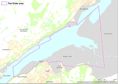
That part of the Menai Strait which lies within a line joining the co-ordinates numbered 1 to 331 in the table below, which extends to approximately 694 hectares and includes the shore and bed of the sea and any river, channel, creek, bay or estuary in the area.
Point | Longitude | Latitude |
|---|---|---|
1 | 004° 4.7317’ W | 053° 14.0637’ N |
2 | 004° 5.6444’ W | 053° 14.1526’ N |
3 | 004° 5.6492’ W | 053° 14.1529’ N |
4 | 004° 5.6626’ W | 053° 14.1514’ N |
5 | 004° 5.6727’ W | 053° 14.1506’ N |
6 | 004° 5.6922’ W | 053° 14.1499’ N |
7 | 004° 5.7014’ W | 053° 14.1490’ N |
8 | 004° 5.7119’ W | 053° 14.1469’ N |
9 | 004° 5.7217’ W | 053° 14.1443’ N |
10 | 004° 5.7353’ W | 053° 14.1402’ N |
11 | 004° 5.7512’ W | 053° 14.1353’ N |
12 | 004° 5.7668’ W | 053° 14.1313’ N |
13 | 004° 5.7861’ W | 053° 14.1276’ N |
14 | 004° 5.8053’ W | 053° 14.1249’ N |
15 | 004° 5.8247’ W | 053° 14.1233’ N |
16 | 004° 5.8416’ W | 053° 14.1227’ N |
17 | 004° 5.8755’ W | 053° 14.1220’ N |
18 | 004° 5.8942’ W | 053° 14.1206’ N |
19 | 004° 5.9102’ W | 053° 14.1181’ N |
20 | 004° 5.9215’ W | 053° 14.1157’ N |
21 | 004° 5.9436’ W | 053° 14.1110’ N |
22 | 004° 5.9609’ W | 053° 14.1087’ N |
23 | 004° 5.9672’ W | 053° 14.1064’ N |
24 | 004° 5.9748’ W | 053° 14.1015’ N |
25 | 004° 5.9843’ W | 053° 14.0966’ N |
26 | 004° 6.0006’ W | 053° 14.0920’ N |
27 | 004° 6.0200’ W | 053° 14.0865’ N |
28 | 004° 6.0439’ W | 053° 14.0786’ N |
29 | 004° 6.0513’ W | 053° 14.0761’ N |
30 | 004° 6.0659’ W | 053° 14.0709’ N |
31 | 004° 6.0702’ W | 053° 14.0691’ N |
32 | 004° 6.0795’ W | 053° 14.0655’ N |
33 | 004° 6.0865’ W | 053° 14.0630’ N |
34 | 004° 6.5983’ W | 053° 14.1197’ N |
35 | 004° 6.6096’ W | 053° 14.1394’ N |
36 | 004° 6.6151’ W | 053° 14.1521’ N |
37 | 004° 6.6215’ W | 053° 14.1742’ N |
38 | 004° 6.6242’ W | 053° 14.1782’ N |
39 | 004° 6.6322’ W | 053° 14.1850’ N |
40 | 004° 6.6432’ W | 053° 14.1903’ N |
41 | 004° 6.6576’ W | 053° 14.1941’ N |
42 | 004° 6.6688’ W | 053° 14.1953’ N |
43 | 004° 6.6775’ W | 053° 14.1954’ N |
44 | 004° 6.6924’ W | 053° 14.1944’ N |
45 | 004° 6.7052’ W | 053° 14.1943’ N |
46 | 004° 6.7087’ W | 053° 14.1949’ N |
47 | 004° 6.7213’ W | 053° 14.2003’ N |
48 | 004° 6.7353’ W | 053° 14.2062’ N |
49 | 004° 6.7463’ W | 053° 14.2095’ N |
50 | 004° 6.7640’ W | 053° 14.2129’ N |
51 | 004° 6.7778’ W | 053° 14.2139’ N |
52 | 004° 7.2577’ W | 053° 14.1640’ N |
53 | 004° 7.2619’ W | 053° 14.1707’ N |
54 | 004° 7.2619’ W | 053° 14.1707’ N |
55 | 004° 7.2688’ W | 053° 14.1771’ N |
56 | 004° 7.2790’ W | 053° 14.1835’ N |
57 | 004° 7.2960’ W | 053° 14.1902’ N |
58 | 004° 7.3038’ W | 053° 14.1941’ N |
59 | 004° 7.3065’ W | 053° 14.1963’ N |
60 | 004° 7.3119’ W | 053° 14.2024’ N |
61 | 004° 7.3128’ W | 053° 14.2032’ N |
62 | 004° 7.3166’ W | 053° 14.2071’ N |
63 | 004° 7.3245’ W | 053° 14.2148’ N |
64 | 004° 7.3298’ W | 053° 14.2184’ N |
65 | 004° 7.3322’ W | 053° 14.2200’ N |
66 | 004° 7.3419’ W | 053° 14.2235’ N |
67 | 004° 7.3450’ W | 053° 14.2214’ N |
68 | 004° 7.4096’ W | 053° 14.1993’ N |
69 | 004° 7.4183’ W | 053° 14.1983’ N |
70 | 004° 7.4282’ W | 053° 14.1958’ N |
71 | 004° 7.4493’ W | 053° 14.1968’ N |
72 | 004° 7.4524’ W | 053° 14.1933’ N |
73 | 004° 7.4612’ W | 053° 14.1901’ N |
74 | 004° 7.4642’ W | 053° 14.1879’ N |
75 | 004° 7.4877’ W | 053° 14.1812’ N |
76 | 004° 7.4965’ W | 053° 14.1801’ N |
77 | 004° 7.5053’ W | 053° 14.1764’ N |
78 | 004° 7.5117’ W | 053° 14.1725’ N |
79 | 004° 7.5220’ W | 053° 14.1699’ N |
80 | 004° 7.5638’ W | 053° 14.1582’ N |
81 | 004° 7.5728’ W | 053° 14.1558’ N |
82 | 004° 7.5886’ W | 053° 14.1538’ N |
83 | 004° 7.6039’ W | 053° 14.1546’ N |
84 | 004° 7.6302’ W | 053° 14.1501’ N |
85 | 004° 7.6434’ W | 053° 14.1480’ N |
86 | 004° 7.6528’ W | 053° 14.1468’ N |
87 | 004° 7.6660’ W | 053° 14.1431’ N |
88 | 004° 7.6747’ W | 053° 14.1387’ N |
89 | 004° 7.6794’ W | 053° 14.1351’ N |
90 | 004° 7.6921’ W | 053° 14.1234’ N |
91 | 004° 7.6998’ W | 053° 14.1185’ N |
92 | 004° 7.7089’ W | 053° 14.1081’ N |
93 | 004° 7.7184’ W | 053° 14.0999’ N |
94 | 004° 7.7272’ W | 053° 14.0938’ N |
95 | 004° 7.7407’ W | 053° 14.0860’ N |
96 | 004° 7.7545’ W | 053° 14.0783’ N |
97 | 004° 7.7589’ W | 053° 14.0761’ N |
98 | 004° 7.7665’ W | 053° 14.0688’ N |
99 | 004° 7.7739’ W | 053° 14.0606’ N |
100 | 004° 7.7828’ W | 053° 14.0540’ N |
101 | 004° 7.7969’ W | 053° 14.0487’ N |
102 | 004° 7.8105’ W | 053° 14.0460’ N |
103 | 004° 7.8239’ W | 053° 14.0448’ N |
104 | 004° 7.8372’ W | 053° 14.0438’ N |
105 | 004° 7.8527’ W | 053° 14.0429’ N |
106 | 004° 7.8714’ W | 053° 14.0420’ N |
107 | 004° 7.8886’ W | 053° 14.0406’ N |
108 | 004° 7.9026’ W | 053° 14.0375’ N |
109 | 004° 7.9116’ W | 053° 14.0338’ N |
110 | 004° 7.9178’ W | 053° 14.0305’ N |
111 | 004° 7.9237’ W | 053° 14.0252’ N |
112 | 004° 7.9275’ W | 053° 14.0188’ N |
113 | 004° 7.9284’ W | 053° 14.0135’ N |
114 | 004° 7.9290’ W | 053° 14.0043’ N |
115 | 004° 7.9325’ W | 053° 13.9960’ N |
116 | 004° 7.9411’ W | 053° 13.9911’ N |
117 | 004° 7.9544’ W | 053° 13.9818’ N |
118 | 004° 7.9624’ W | 053° 13.9773’ N |
119 | 004° 7.9709’ W | 053° 13.9732’ N |
120 | 004° 7.9787’ W | 053° 13.9701’ N |
121 | 004° 7.9867’ W | 053° 13.9659’ N |
122 | 004° 7.9958’ W | 053° 13.9590’ N |
123 | 004° 8.0015’ W | 053° 13.9552’ N |
124 | 004° 8.0098’ W | 053° 13.9512’ N |
125 | 004° 8.0231’ W | 053° 13.9464’ N |
126 | 004° 8.0290’ W | 053° 13.9412’ N |
127 | 004° 8.0411’ W | 053° 13.9326’ N |
128 | 004° 8.0559’ W | 053° 13.9227’ N |
129 | 004° 8.0619’ W | 053° 13.9185’ N |
130 | 004° 8.0708’ W | 053° 13.9132’ N |
131 | 004° 8.0794’ W | 053° 13.9107’ N |
132 | 004° 8.0870’ W | 053° 13.9079’ N |
133 | 004° 8.0927’ W | 053° 13.9047’ N |
134 | 004° 8.1003’ W | 053° 13.9021’ N |
135 | 004° 8.1110’ W | 053° 13.8972’ N |
136 | 004° 8.1232’ W | 053° 13.8946’ N |
137 | 004° 8.1298’ W | 053° 13.8911’ N |
138 | 004° 8.1377’ W | 053° 13.8851’ N |
139 | 004° 8.1451’ W | 053° 13.8801’ N |
140 | 004° 8.1533’ W | 053° 13.8765’ N |
141 | 004° 8.1609’ W | 053° 13.8744’ N |
142 | 004° 8.1715’ W | 053° 13.8719’ N |
143 | 004° 8.1788’ W | 053° 13.8681’ N |
144 | 004° 8.1822’ W | 053° 13.8619’ N |
145 | 004° 8.1876’ W | 053° 13.8577’ N |
146 | 004° 8.1937’ W | 053° 13.8550’ N |
147 | 004° 8.2029’ W | 053° 13.8534’ N |
148 | 004° 8.2299’ W | 053° 13.8533’ N |
149 | 004° 8.2447’ W | 053° 13.8542’ N |
150 | 004° 8.2677’ W | 053° 13.8567’ N |
151 | 004° 8.2851’ W | 053° 13.8566’ N |
152 | 004° 8.2986’ W | 053° 13.8550’ N |
153 | 004° 8.2989’ W | 053° 13.8550’ N |
154 | 004° 8.3174’ W | 053° 13.8524’ N |
155 | 004° 8.3424’ W | 053° 13.8502’ N |
156 | 004° 8.3597’ W | 053° 13.8487’ N |
157 | 004° 8.3686’ W | 053° 13.8478’ N |
158 | 004° 8.3893’ W | 053° 13.8449’ N |
159 | 004° 8.4027’ W | 053° 13.8433’ N |
160 | 004° 8.4319’ W | 053° 13.8402’ N |
161 | 004° 8.4557’ W | 053° 13.8374’ N |
162 | 004° 8.4751’ W | 053° 13.8342’ N |
163 | 004° 8.4891’ W | 053° 13.8309’ N |
164 | 004° 8.5048’ W | 053° 13.8262’ N |
165 | 004° 8.5282’ W | 053° 13.8187’ N |
166 | 004° 8.5509’ W | 053° 13.8113’ N |
167 | 004° 8.5660’ W | 053° 13.8067’ N |
168 | 004° 8.5973’ W | 053° 13.7972’ N |
169 | 004° 8.6133’ W | 053° 13.7923’ N |
170 | 004° 8.6248’ W | 053° 13.7889’ N |
171 | 004° 8.6840’ W | 053° 13.7702’ N |
172 | 004° 8.6931’ W | 053° 13.7675’ N |
173 | 004° 8.7067’ W | 053° 13.7645’ N |
174 | 004° 8.7300’ W | 053° 13.7575’ N |
175 | 004° 8.7507’ W | 053° 13.7514’ N |
176 | 004° 8.7611’ W | 053° 13.7484’ N |
177 | 004° 8.7619’ W | 053° 13.7482’ N |
178 | 004° 8.7704’ W | 053° 13.7460’ N |
179 | 004° 8.8201’ W | 053° 14.0223’ N |
180 | 004° 8.6395’ W | 053° 14.0900’ N |
181 | 004° 8.3600’ W | 053° 14.2610’ N |
182 | 004° 8.0340’ W | 053° 14.4070’ N |
183 | 004° 7.6740’ W | 053° 14.5434’ N |
184 | 004° 7.6493’ W | 053° 14.5528’ N |
185 | 004° 7.6461’ W | 053° 14.5540’ N |
186 | 004° 7.6978’ W | 053° 14.6130’ N |
187 | 004° 7.1553’ W | 053° 14.7845’ N |
188 | 004° 7.2301’ W | 053° 14.8594’ N |
189 | 004° 7.2261’ W | 053° 14.8603’ N |
190 | 004° 7.2121’ W | 053° 14.8640’ N |
191 | 004° 7.1872’ W | 053° 14.8716’ N |
192 | 004° 7.1756’ W | 053° 14.8749’ N |
193 | 004° 7.1655’ W | 053° 14.8780’ N |
194 | 004° 7.1523’ W | 053° 14.8821’ N |
195 | 004° 7.1382’ W | 053° 14.8874’ N |
196 | 004° 7.1248’ W | 053° 14.8932’ N |
197 | 004° 7.1179’ W | 053° 14.8967’ N |
198 | 004° 7.1089’ W | 053° 14.9020’ N |
199 | 004° 7.0999’ W | 053° 14.9083’ N |
200 | 004° 7.0901’ W | 053° 14.9143’ N |
201 | 004° 7.0840’ W | 053° 14.9177’ N |
202 | 004° 7.0694’ W | 053° 14.9264’ N |
203 | 004° 7.0553’ W | 053° 14.9342’ N |
204 | 004° 7.0416’ W | 053° 14.9404’ N |
205 | 004° 7.0293’ W | 053° 14.9461’ N |
206 | 004° 7.0232’ W | 053° 14.9491’ N |
207 | 004° 7.0112’ W | 053° 14.9547’ N |
208 | 004° 6.9963’ W | 053° 14.9618’ N |
209 | 004° 6.9814’ W | 053° 14.9697’ N |
210 | 004° 6.9688’ W | 053° 14.9750’ N |
211 | 004° 6.9594’ W | 053° 14.9785’ N |
212 | 004° 6.9520’ W | 053° 14.9808’ N |
213 | 004° 6.9410’ W | 053° 14.9834’ N |
214 | 004° 6.9244’ W | 053° 14.9859’ N |
215 | 004° 6.9126’ W | 053° 14.9867’ N |
216 | 004° 6.8986’ W | 053° 14.9873’ N |
217 | 004° 6.8886’ W | 053° 14.9885’ N |
218 | 004° 6.8784’ W | 053° 14.9909’ N |
219 | 004° 6.8714’ W | 053° 14.9937’ N |
220 | 004° 6.8618’ W | 053° 14.9994’ N |
221 | 004° 6.8507’ W | 053° 15.0070’ N |
222 | 004° 6.8412’ W | 053° 15.0130’ N |
223 | 004° 6.8306’ W | 053° 15.0189’ N |
224 | 004° 6.8211’ W | 053° 15.0231’ N |
225 | 004° 6.8154’ W | 053° 15.0252’ N |
226 | 004° 6.7993’ W | 053° 15.0304’ N |
227 | 004° 6.7877’ W | 053° 15.0344’ N |
228 | 004° 6.7746’ W | 053° 15.0386’ N |
229 | 004° 6.7634’ W | 053° 15.0422’ N |
230 | 004° 6.7521’ W | 053° 15.0462’ N |
231 | 004° 6.7405’ W | 053° 15.0506’ N |
232 | 004° 6.7352’ W | 053° 15.0526’ N |
233 | 004° 6.7205’ W | 053° 15.0581’ N |
234 | 004° 6.7041’ W | 053° 15.0653’ N |
235 | 004° 6.6875’ W | 053° 15.0727’ N |
236 | 004° 6.6742’ W | 053° 15.0789’ N |
237 | 004° 6.6666’ W | 053° 15.0818’ N |
238 | 004° 6.6595’ W | 053° 15.0839’ N |
239 | 004° 6.6425’ W | 053° 15.0885’ N |
240 | 004° 6.6325’ W | 053° 15.0910’ N |
241 | 004° 6.6237’ W | 053° 15.0930’ N |
242 | 004° 6.6135’ W | 053° 15.0951’ N |
243 | 004° 6.5925’ W | 053° 15.1011’ N |
244 | 004° 6.5696’ W | 053° 15.1095’ N |
245 | 004° 6.5588’ W | 053° 15.1136’ N |
246 | 004° 6.5455’ W | 053° 15.1181’ N |
247 | 004° 6.5364’ W | 053° 15.1212’ N |
248 | 004° 6.5247’ W | 053° 15.1251’ N |
249 | 004° 6.5199’ W | 053° 15.1269’ N |
250 | 004° 6.4993’ W | 053° 15.1345’ N |
251 | 004° 6.4896’ W | 053° 15.1381’ N |
252 | 004° 6.4748’ W | 053° 15.1449’ N |
253 | 004° 6.4629’ W | 053° 15.1509’ N |
254 | 004° 6.4503’ W | 053° 15.1569’ N |
255 | 004° 6.4372’ W | 053° 15.1611’ N |
256 | 004° 6.4323’ W | 053° 15.1612’ N |
257 | 004° 6.4172’ W | 053° 15.1583’ N |
258 | 004° 6.4059’ W | 053° 15.1565’ N |
259 | 004° 6.4059’ W | 053° 15.1565’ N |
260 | 004° 6.4059’ W | 053° 15.1565’ N |
261 | 004° 6.4005’ W | 053° 15.1552’ N |
262 | 004° 6.3925’ W | 053° 15.1519’ N |
263 | 004° 6.3836’ W | 053° 15.1470’ N |
264 | 004° 6.3746’ W | 053° 15.1431’ N |
265 | 004° 6.3669’ W | 053° 15.1418’ N |
266 | 004° 6.3540’ W | 053° 15.1454’ N |
267 | 004° 6.3512’ W | 053° 15.1451’ N |
268 | 004° 6.3479’ W | 053° 15.1402’ N |
269 | 004° 6.3426’ W | 053° 15.1351’ N |
270 | 004° 6.3383’ W | 053° 15.1336’ N |
271 | 004° 6.3307’ W | 053° 15.1341’ N |
272 | 004° 6.3263’ W | 053° 15.1368’ N |
273 | 004° 6.3220’ W | 053° 15.1391’ N |
274 | 004° 6.3106’ W | 053° 15.1428’ N |
275 | 004° 6.3056’ W | 053° 15.1447’ N |
276 | 004° 6.3056’ W | 053° 15.1447’ N |
277 | 004° 6.4403’ W | 053° 15.2247’ N |
278 | 004° 6.4371’ W | 053° 15.2266’ N |
279 | 004° 6.4309’ W | 053° 15.2309’ N |
280 | 004° 6.4204’ W | 053° 15.2372’ N |
281 | 004° 6.4078’ W | 053° 15.2440’ N |
282 | 004° 6.3985’ W | 053° 15.2491’ N |
283 | 004° 6.3847’ W | 053° 15.2560’ N |
284 | 004° 6.3704’ W | 053° 15.2621’ N |
285 | 004° 6.3605’ W | 053° 15.2658’ N |
286 | 004° 6.3510’ W | 053° 15.2699’ N |
287 | 004° 6.3477’ W | 053° 15.2715’ N |
288 | 004° 6.3446’ W | 053° 15.2730’ N |
289 | 004° 6.3298’ W | 053° 15.2789’ N |
290 | 004° 6.3165’ W | 053° 15.2815’ N |
291 | 004° 6.3037’ W | 053° 15.2824’ N |
292 | 004° 6.2870’ W | 053° 15.2828’ N |
293 | 004° 6.2761’ W | 053° 15.2827’ N |
294 | 004° 6.2523’ W | 053° 15.2820’ N |
295 | 004° 6.2352’ W | 053° 15.2805’ N |
296 | 004° 6.2223’ W | 053° 15.2799’ N |
297 | 004° 6.2152’ W | 053° 15.2809’ N |
298 | 004° 6.2056’ W | 053° 15.2814’ N |
299 | 004° 6.1940’ W | 053° 15.2800’ N |
300 | 004° 6.1811’ W | 053° 15.2777’ N |
301 | 004° 6.1657’ W | 053° 15.2750’ N |
302 | 004° 6.1380’ W | 053° 15.2701’ N |
303 | 004° 6.1272’ W | 053° 15.2687’ N |
304 | 004° 6.1174’ W | 053° 15.2680’ N |
305 | 004° 6.1053’ W | 053° 15.2681’ N |
306 | 004° 6.0886’ W | 053° 15.2696’ N |
307 | 004° 6.0781’ W | 053° 15.2713’ N |
308 | 004° 6.0662’ W | 053° 15.2741’ N |
309 | 004° 6.0579’ W | 053° 15.2767’ N |
310 | 004° 6.0028’ W | 053° 15.1918’ N |
311 | 004° 5.0706’ W | 053° 15.7180’ N |
(This note is not part of the Order)
This Order confers on the Menai Strait Fishery Order Management Association (Company number: 07163689) (“the Grantee”) a right of several fishery and a right of regulating a fishery for prescribed species of shellfish. The prescribed species are mussels and oysters. The rights subsist over an area of approximately 694 hectares of the foreshore and bed of the Menai Strait in the counties of Gwynedd and Anglesey as specified in the Schedule to this Order (“the Order area”). The right of several fishery and the right of regulating a fishery are conferred on the Grantee for a period of 35 years commencing on 2 April 2022.
Part 1 of the Order makes provision for introductory matters. Article 1 of the Order provides for the title, commencement and application. Article 2 provides for interpretation of the Order.
Part 2 of the Order makes provision for the exercise of the right of several fishery. Article 3 confers a right of several fishery on the Grantee over the several fishery area. Article 4 provides that the Grantee may designate, with the consent of the Welsh Ministers, any part of the Order area as the several fishery area. Article 5 provides for the Welsh Ministers’ consent to the designation. Article 6 provides that the Grantee may cancel a designation of the several fishery area. Article 7 provides for the Welsh Ministers’ consent to a cancellation. Article 8 prohibits the Grantee from exercising the right of several fishery and provides that they can, subject to certain restrictions including a requirement for Welsh Ministers’ consent, grant a lease of the right of several fishery across all or part of the several fishery area (“a laying”) to others (“the tenants”). Article 9 provides for the Welsh Ministers’ consent to the grant of a lease of the right of several fishery. Article 10 requires the Grantee to take all reasonable steps to monitor the tenant’s compliance with a lease. Article 11 provides for the effect of a lease. Article 12 provides that if a laying becomes vacant the Grantee must advertise the opportunity to apply for a lease and the criteria against which an application will be assessed. Article 13 requires the Grantee apply any rents received by them under a lease for specified purposes.
Part 3 of the Order makes provision for the exercise of the right of regulating a fishery. Article 14 confers a right of regulating a fishery in relation to the regulated fishery area. Article 2 provides that the regulated fishery area is any part of the Order area not designated as the several fishery area under article 4. Article 15 prohibits any person from dredging for, fishing for or taking any of the prescribed species in the regulated fishery area without a licence. Article 16 provides for the matters that the Grantee must have regard to when exercising their licensing functions. Article 17 provides for licence applications, for publication of information about the licence application process and for amendment of a licence. Article 18 sets out details which must be included in all licences. Article 19 provides for the toll payable upon a licence application. Article 20 provides that the Grantee may, with the consent of the Welsh Ministers, make regulations in relation to the dredging, fishing for or taking of any of the prescribed species in the regulated fishery. Article 21 provides for the Welsh Ministers’ consent to regulations made under article 20.
Part 4 of the Order makes miscellaneous provision applicable to both rights of fishery. Article 22 requires the Grantee to keep publicly available an illustrative map of the Order area. Article 23 requires the Grantee to provide to the Welsh Ministers accounts of income and expenditure, other information regarding the Order and to permit the Welsh Ministers to inspect the Order area. Article 24 requires the Grantee to submit an annual catch return to the Welsh Ministers. Article 25 provides that the Welsh Ministers may request that the Grantee mark out the Order area and the boundary between the several fishery area and the regulated fishery area. Article 26 provides that nothing in this Order will affect prejudicially the rights of landowners in the Order area. Article 27 provides that nothing in this Order will affect prejudicially the exercise of any statutory functions by a statutory undertaker. Article 28 revokes the Menai Strait Oyster and Mussel Fishery Order 1962 (S.I. 1962/705) and the Menai Strait Oyster and Mussel Fishery (Amendment) Order 1964 (S.I. 1964/550).
The Schedule to the Order sets out the co-ordinates of the Order area. An illustrative map of the Order area is included at the end of this note.
The rights of fishery conferred by this Order are subject to sections 5 to 5E of the Sea Fisheries (Shellfish) Act 1967 (“the Act”). Section 5(1) of the Act provides the Welsh Ministers with a power to determine the fishery if they are not satisfied that the Grantee is properly cultivating or carrying into effect this Order. Section 5A of the Act provides that any order made by the Welsh Ministers under section 1 of the Act must contain appropriate provision to prevent harm to any European marine site and for protecting the marine environment. Section 5B of the Act provides the Welsh Ministers with power to serve a site protection notice on the Grantee if it appears to them that harm to a European marine site has occurred, or is likely to occur, as a result of any activity carried out in exercise of a right conferred under this Order. A site protection notice may require the Grantee to take steps to prevent harm (or further harm) to the European marine site. Under Section 5C the Grantee may appeal against a site protection notice. Section 5D provides that the Welsh Ministers may, in the event the Grantee does not comply with a notice, take the steps identified in the notice themselves, and recover any costs incurred from the Grantee. Section 5E provides that if the Grantee fails to comply with the notice, and has not appealed against it, the Welsh Ministers may vary or revoke this Order to reflect the effect of the site protection notice.
The Welsh Ministers’ Code of Practice on the carrying out of Regulatory Impact Assessments was considered in relation to this Order. As a result, a Regulatory Impact Assessment has been prepared as to the likely costs and benefits of complying with this Order. A copy can be obtained from the Welsh Government, Cathays Park, Cardiff, CF10 3NQ.