- Latest available (Revised)
- Original (As made)
The Traffic Signs Regulations and General Directions 2016
You are here:

What Version
More Resources
Status:
This is the original version (as it was originally made). This item of legislation is currently only available in its original format.
PART 4Advisory road markings
Sign table — Schedule 11, Part 4
(1) Item | (2) Description and diagram | (3) Permitted or required variants in Part 5 | (4) Requirements applicable in Part 6 |
|---|---|---|---|
| 1 | Diagram 1003.1 Vehicular traffic approaching a roundabout should give way at or immediately beyond the line to vehicular traffic circulating on the carriageway of the roundabout 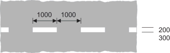 | 7 | |
| 2 | Diagram 1004 Vehicular traffic should not cross or straddle the line unless it is safe to do so and when the line is used to indicate a cycle lane, motor vehicles should not enter that lane unless it is clear of pedal cycles (Longitudinal marking)  | 57 | 7, 8, 10, 12 |
| 3 | Diagram 1004.1 Vehicular traffic should not cross or straddle the line unless it is safe to do so and when the line is used to indicate a cycle lane, motor vehicles should not enter that lane unless it is clear of pedal cycles (Longitudinal marking)  | 7, 8, 10, 12 | |
| 4 | Diagram 1005 Division of carriageway into traffic lanes on part of the carriageway where vehicles normally proceed in the same direction other than at places where the marking at item 2 of this table is used (Longitudinal marking)  | 7, 8, 10, 12 | |
| 5 | Diagram 1005.1 As the marking at item 4 other than at places where the marking at item 3 is used (Longitudinal marking) 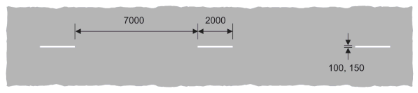 | 7, 8, 10, 12 | |
| 6 | Diagram 1008 Division between opposing flows of traffic on a carriageway other than at places where the marking at item 2 is used (Longitudinal marking)  | 57 | 7, 8, 10, 12 |
| 7 | Diagram 1008.1 Division between opposing flows of traffic on a carriageway other than at places where the marking at item 3 is used (Longitudinal marking) 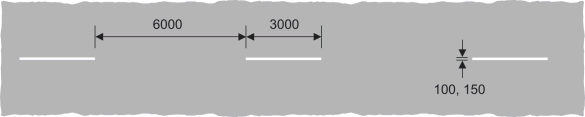 | 7, 8, 10, 12 | |
| 8 | Diagram 1009A Edge of the carriageway at a road junction, exit from a private drive onto a public road, or the start of a cycle lane (Longitudinal marking) 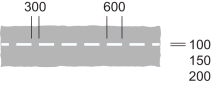 | 7 | |
| 9 | Diagram 1009B Edge of the carriageway at a junction of a cycle track and another road (Longitudinal marking) 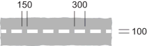 | ||
| 10 | Diagram 1010 (a) edge of the carriageway at a road junction or a lay-by, or at an exit from a private drive onto a public road; (b) the start of a traffic lane, the boundary of which is indicated by the road marking shown at item 11 of the table in Part 6 of Schedule 9; (c) when used in conjunction with the road marking at item 4 of the sign table in Part 4 of Schedule 2, the most suitable path to be taken by high vehicles under a low bridge or to avoid an overhanging structure; (d) when laid alongside rails used by tramcars, the edge of the part of the carriageway used by the tramcars; (e) the division between the main carriageway and a traffic lane which leaves the main carriageway at a junction ahead; (f) the boundary between the main carriageway and either a diverging or merging traffic lane at a road junction; (g) the boundary between an emergency refuge area and either an actively managed hard shoulder or the edge of carriageway of a motorway; or (h) the division between the main carriageway and a cycle lane through a junction (Longitudinal marking)  | 41 | 7, 8, 11, 12 |
| 11 | Diagram 1012.1 (a) edge of the carriageway available for through traffic other than at a road junction, an exit from a private drive onto a public road, lay-by or emergency refuge area; (b) the back edge of a hard shoulder; (c) the edge of a footway where it passes over a railway or tramway level crossing; or (d) the boundary between the carriageway of a motorway and an actively managed hard shoulder (Longitudinal marking)  | 7, 9, 11, 12 | |
| 12 | Diagram 1012.2 (a) edge of carriageway of a motorway other than at an emergency refuge area or a junction with a slip road; or (b) the back edge of an actively managed hard shoulder; and, in both cases, incorporating an audible and tactile warning (Longitudinal marking) 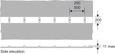 | 42 | 3, 7, 9, 11, 12 |
| 13 | Diagram 1012.3 Edge of carriageway of a road that is not a motorway and which has hard strips or hard shoulders, other than at a junction with a slip road, and incorporating an audible and tactile warning (Longitudinal marking) 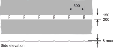 | 43 | 3, 7, 9, 11, 12 |
| 14 | Diagram 1014 (a) Direction in which vehicular traffic should pass a road marking shown at item 7, 11 or 23 of the sign table in Part 6 of Schedule 9 or at item 23, 24 or 25 of the sign table in Part 4 of this Schedule; (b) obstruction on the carriageway ahead; (c) reduction in the number to traffic lanes in the carriageway ahead; or (d) path to be taken by vehicular traffic to avoid a route available for tramcars only (Longitudinal marking) (Alternative types) 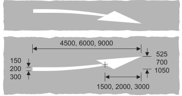 | 7 | |
| 15 | Diagram 1024 Vehicular traffic should proceed with caution because of potential danger ahead 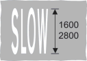 | 7 | |
| 16 | Diagram 1026 Part of the carriageway which should be kept clear of stationary vehicles (Alternative types) 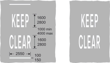 | ||
| 17 | Diagram 1026.1 Part of the carriageway outside a vehicular entrance to adjacent premises or a private drive, or where the kerb is dropped to provide a convenient crossing place for pedestrians, which should be kept clear of waiting vehicles 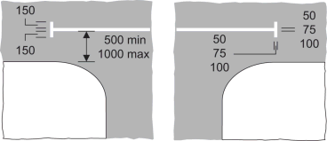 | ||
| 18 | Diagram 1029 Direction in which pedestrians should look for approaching traffic 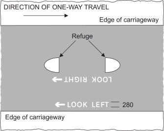 | 44 | |
| 19 | Diagram 1035 Appropriate traffic lanes for different destinations (Alternative types) 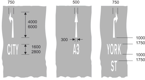 | 45 | |
| 20 | Diagram 1038 Appropriate traffic lanes for different manoeuvres (Longitudinal marking) (Alternative types) 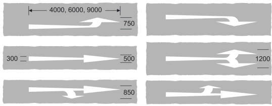 | ||
| 21 | Diagram 1038.1 Appropriate direction to be taken by traffic turning within a junction (Alternative types) 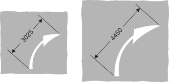 | 46 | |
| 22 | Diagram 1039 Place where traffic streams divide or bifurcate (Longitudinal marking) (Alternative types) 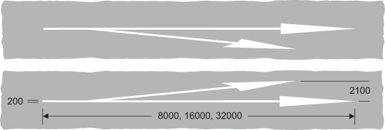 | 7 | |
| 23 | Diagram 1040 Part of the carriageway which vehicular traffic should not enter unless it is seen by the driver to be safe to do so (Alternative types) 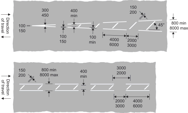 | 47 | 7, 8, 10, 12 |
| 24 | Diagram 1040.3 Reduction in the number of lanes, or area not available to traffic, on the main carriageway or slip road of a motorway or all-purpose dual carriageway road 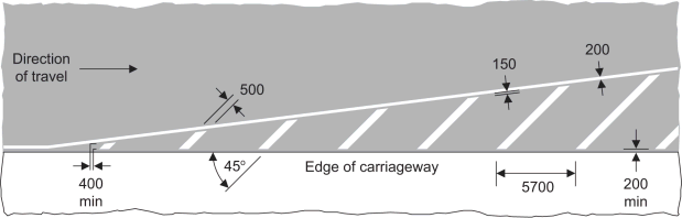 | 48 | 7, 8, 11, 12 |
| 25 | Diagram 1040.4 Part of the carriageway adjacent to the edge which vehicular traffic should not enter unless it is seen by the driver to be safe to do so 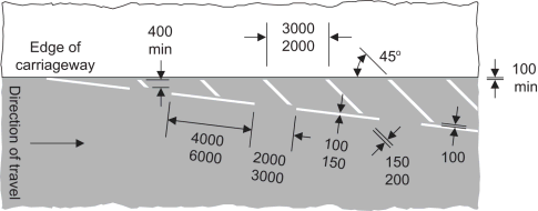 | 49 | 7, 8, 11, 12 |
| 26 | Diagram 1040.5 End of a hard shoulder 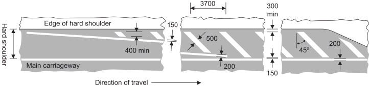 | 50 | 7, 8, 11, 12 |
| 27 | Diagram 1041 Part of the carriageway where vehicular traffic passes in the same direction on both sides of the marking, and should not enter the area covered by the marking unless it is seen by the driver to be safe to do so (Alternative types) 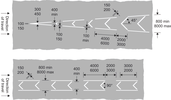 | 51 | 7, 8, 11, 12 |
| 28 | Diagram 1057 Cycle lane, track or route (Alternative types)  | ||
| 29 | Diagram 1057.1 Number of a cycle route (Alternative types)  | 29 | |
| 30 | Diagram 1058 End of a cycle lane, track or route  | ||
| 31 | Diagram 1058.1 Pedal cycles should proceed with caution because of potential danger ahead  | ||
| 32 | Diagram 1059 Directions in which pedal cycles should travel along a cycle lane, track or route (Alternative types) 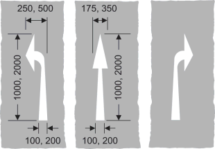 | ||
| 33 | Diagram 1062 Road hump 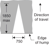 | 7 | |
| 34 | Diagram 1064 Marking used in conjunction with the sign shown at item 50 of the sign table in Part 2 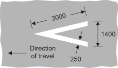 | 7 | |
| 35 | Diagram 1067 Transverse yellow bar markings for use only on approaches to roundabouts on motorways and dual carriageway roads subject to the national speed limit, either on the main carriageway or on an exit slip road 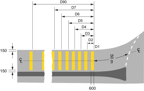 | 52 | 14, 15 |
| 36 | Diagram 1066 Edge of part of the road used by tramcars (Longitudinal marking)  |
Options/Help
Print Options
PrintThe Whole Instrument
PrintThe Whole Schedule
PrintThis Part only
You have chosen to open The Whole Instrument
The Whole Instrument you have selected contains over 200 provisions and might take some time to download. You may also experience some issues with your browser, such as an alert box that a script is taking a long time to run.
Would you like to continue?
You have chosen to open The Whole Instrument as a PDF
The Whole Instrument you have selected contains over 200 provisions and might take some time to download.
Would you like to continue?
You have chosen to open the Whole Instrument
The Whole Instrument you have selected contains over 200 provisions and might take some time to download. You may also experience some issues with your browser, such as an alert box that a script is taking a long time to run.
Would you like to continue?
You have chosen to open Schedules only
The Schedules you have selected contains over 200 provisions and might take some time to download. You may also experience some issues with your browser, such as an alert box that a script is taking a long time to run.
Would you like to continue?

Legislation is available in different versions:
Latest Available (revised):The latest available updated version of the legislation incorporating changes made by subsequent legislation and applied by our editorial team. Changes we have not yet applied to the text, can be found in the ‘Changes to Legislation’ area.
Original (As Enacted or Made): The original version of the legislation as it stood when it was enacted or made. No changes have been applied to the text.
Opening Options
Different options to open legislation in order to view more content on screen at once
Explanatory Memorandum
Explanatory Memorandum sets out a brief statement of the purpose of a Statutory Instrument and provides information about its policy objective and policy implications. They aim to make the Statutory Instrument accessible to readers who are not legally qualified and accompany any Statutory Instrument or Draft Statutory Instrument laid before Parliament from June 2004 onwards.
More Resources
Access essential accompanying documents and information for this legislation item from this tab. Dependent on the legislation item being viewed this may include:
- the original print PDF of the as enacted version that was used for the print copy
- lists of changes made by and/or affecting this legislation item
- confers power and blanket amendment details
- all formats of all associated documents
- correction slips
- links to related legislation and further information resources
Impact Assessments
Impact Assessments generally accompany all UK Government interventions of a regulatory nature that affect the private sector, civil society organisations and public services. They apply regardless of whether the regulation originates from a domestic or international source and can accompany primary (Acts etc) and secondary legislation (SIs). An Impact Assessment allows those with an interest in the policy area to understand:
- Why the government is proposing to intervene;
- The main options the government is considering, and which one is preferred;
- How and to what extent new policies may impact on them; and,
- The estimated costs and benefits of proposed measures.
More Resources
Use this menu to access essential accompanying documents and information for this legislation item. Dependent on the legislation item being viewed this may include:
- the original print PDF of the as made version that was used for the print copy
- correction slips
Click 'View More' or select 'More Resources' tab for additional information including:
- lists of changes made by and/or affecting this legislation item
- confers power and blanket amendment details
- all formats of all associated documents
- links to related legislation and further information resources
 All content is available under the Open Government Licence v3.0 except where otherwise stated. This site additionally contains content derived from EUR-Lex, reused under the terms of the Commission Decision 2011/833/EU on the reuse of documents from the EU institutions. For more information see the EUR-Lex public statement on re-use.