Statutory Instruments
1993 No. 493
LOCAL GOVERNMENT, ENGLAND AND WALES
CHANGES IN LOCAL GOVERNMENT AREAS
The Cheshire, Derbyshire and Greater Manchester (County and District Boundaries) Order 1993
Made
1st March 1993
Laid before Parliament
11th March 1993
Coming into force for the purposes referred
to in article 1(2)
1st December 1993
for all other purposes
1st April 1994
The Secretary of State, in exercise of his powers under sections 51(2) and 67(4) of the Local Government Act 1972(1) and of all other powers enabling him in that behalf, hereby makes the following Order which gives effect, with modifications, to proposals submitted to him under sections 47, 48(1) and 51(1) of that Act, more than six weeks before the making of this Order, by the Local Government Boundary Commission for England:
Citation and commencement
1.—(1) This Order may be cited as the Cheshire, Derbyshire and Greater Manchester (County and District Boundaries) Order 1993.
(2) This Order shall come into force on 1st December 1993 for any purpose set out in regulation 4(1) of the Local Government Area Changes Regulations 1976(2).
(3) For all other purposes, this Order shall come into force on 1st April 1994.
Interpretation
2. In this Order—
“Cheshire” means the county of Cheshire, and “Macclesfield” means the Cheshire borough of Macclesfield;
“Derbyshire” means the county of Derbyshire, and “High Peak” means the Derbyshire borough of High Peak;
“district” includes a borough and a metropolitan borough;
“electoral division” means an electoral division of the county to which an area is transferred by this Order(3);
“Greater Manchester” means the metropolitan county of Greater Manchester, and any reference to Stockport or to Tameside is a reference to the metropolitan borough of that name;
“the map” means one or more of the 13 maps prepared by the Department of the Environment, marked “Maps of the Cheshire, Derbyshire and Greater Manchester (County and District Boundaries) Order 1993”, and deposited in accordance with regulation 5 of the Local Government Area Changes Regulations 1976;
any reference to an area as unparished is a reference to that area not forming part of any parish; and
“ward” means a ward of the district from or to which an area is transferred, except in the expression “parish ward”, where it means a ward of the parish to which an area is transferred(4).
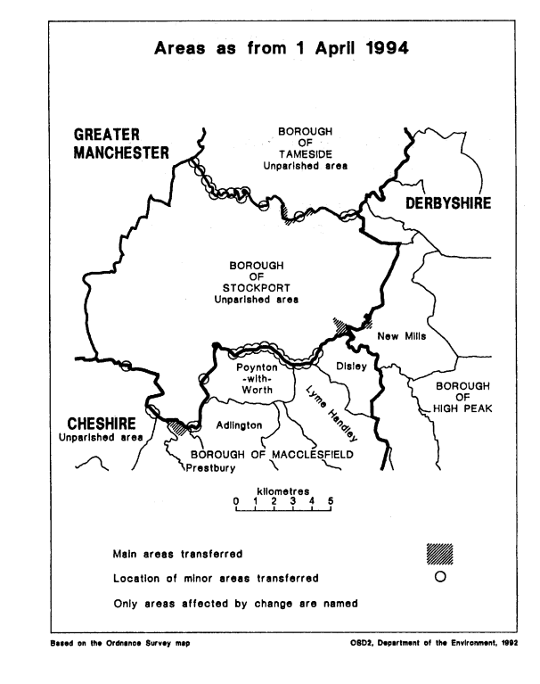
Transfers between Cheshire (Macclesfield) and Greater Manchester (Stockport)
3.—(1) Each area which is marked as shown in column 1 of the following Table on the map indicated in column 2 shall be transferred from Cheshire, from Macclesfield and from the parish (or, if unparished, the ward) named in column 3 to—
(a)Greater Manchester;
(b)Stockport, and the ward named in column 4; and to
(c)the Stockport Metropolitan District petty sessional division and the Greater Manchester South coroner’s district—
and shall become or remain unparished.
TABLE
| (1) | (2) | (3) | (4) |
|---|---|---|---|
| Area marked | On map— | Transferred from Cheshire, from Macclesfield and from— | To Greater Manchester, to Stockport, and to the following ward— |
| B52, B53 & B54 | 7 | Parish of Adlington | West Bramhall |
| B71, B72, B73, B74 & B75 | 13 | Parish of Disley | South Marple |
| B67, B68 & B69 | 11 | Parish of Lyme Handley | South Marple |
| B59, B60, B61 & B62 | 9 | Parish of Poynton—with—Worth | East Bramhall |
| B63 & B64 | 9 | Parish of Poynton—with—Worth | Hazel Grove |
| B65 & B66 | 10 | ||
| B55, B56, B57 & B58 | 8 | Parish of Poynton—with—Worth | West Bramhall |
| B49, B50 & B51 | 7 | Parish of Prestbury | West Bramhall |
| B48 | 6 | Dean Row ward | West Bramhall |
| B46 | 5 | Handforth ward | Cheadle Hulme South |
| B43 | 5 | Handforth ward | Heald Green |
(2) Each unparished area which is marked as shown in column 1 of the following Table on the map indicated in column 2 shall be transferred from Greater Manchester, from Stockport, and from the ward named in column 3 to—
(a)Cheshire;
(b)Macclesfield;
(c)the parish (if any), ward and electoral division mentioned in column 4; and to
(d)the Macclesfield petty sessional division and the Cheshire coroner’s district.
| (1) | (2) | (3) | (4) |
|---|---|---|---|
| Area marked | On map— | Transferred from Greater Manchester (Stockport) and from the ward of— | To Cheshire, to Macclesfield and to— |
| B45 | 5 | Cheadle Hulme South | Handforth ward Wilmslow Dean electoral division |
C11, C12 & C13 | 9 | East Bramhall | Parish of Poynton—with—worth Poynton West ward Poynton electoral division |
C14, C15 & C16 | 9 | Hazel Grove | Parish of Poynton—with—Worth Poynton Central ward Poynton electoral division |
C17, C18 & C19 C20 | 10 10 & 11 | Hazel Grove | Parish of Poynton—with—Worth Poynton East ward Poynton electoral division |
| B44 | 5 | Heald Green | Handforth ward Wilmslow Dean electoral division |
| B70 & B76 | 13 | South Marple | Parish of Disley Disley ward Bollington and Disley electoral division |
C22 & C23 C24 & C25 | 11 12 | South Marple | Parish of Lyme Handley Rainow ward Bollington and Disley electoral division |
| C21 | 11 | South Marple | Parish of Poynton—with—Worth Poynton East ward Poynton electoral division |
| B47 | 6 | West Bramhall | Dean Row ward Wilmslow Dean electoral division |
| C6, C7 & C8 | 7 | West Bramhall | Parish of Adlington Prestbury ward Poynton electoral division |
| C9 & C10 | 8 | West Bramhall | Parish of Poynton—with—Worth Poynton West ward Poynton electoral division |
| C3, C4 & C5 | 7 | West Bramhall | Parish of Prestbury Prestbury ward Upton and Prestbury electoral division |
Transfers between Derbyshire (High Peak) and Greater Manchester (Stockport)
4.—(1) The area marked B42 on map 4 shall be transferred from Derbyshire, from High Peak, and from the parish of New Mills to—
(a)Greater Manchester;
(b)Stockport, and the South Marple ward; and to
(c)the Stockport petty sessional division and the Greater Manchester South coroner’s district—
and shall become unparished.
(2) The unparished areas marked C1 and C2 on map 4 shall be transferred from Greater Manchester, from Stockport, and from the South Marple ward to—
(a)Derbyshire;
(b)High Peak;
(c)the parish of New Mills and the Whitle parish ward;
(d)the New Mills North ward and the New Mills electoral division; and to
(e)the High Peak petty sessional division and the High Peak coroner’s district.
Transfers within Greater Manchester between Stockport and Tameside
5.—(1) Each area which is marked as shown in column 1 of the following Table on the map indicated in column 2 shall be transferred from Stockport, and from the ward named in column 3 to Tameside, and to the ward and petty sessional division named in column 4.
TABLE
| (1) | (2) | (3) | (4) |
|---|---|---|---|
| Area marked | On map | Transferred from Stockport, and from the following ward— | To Tameside, and to— |
B20 & B21 B24 | 2 3 | Bredbury | Denton South ward Ashton under Lyne petty sessional division |
B11a, B13 & B15 | 2 | Bredbury | Denton West ward Ashton under Lyne petty sessional division |
B25, B27 & B29 | 3 | Bredbury | Hyde Werneth ward South Tameside petty sessional division |
| B7, B9 & B11 | 2 | Brinnington | Denton West ward Ashton under Lyne petty sessional division |
| B38 & B40 | 3 | North Marple | Hyde Werneth ward South Tameside petty sessional division |
B3 B5 | 1 2 | North Reddish | Denton West ward Ashton under Lyne petty sessional division |
B31, B33, B34 & B36 | 1 | Romiley | Hyde Werneth ward South Tameside petty sessional division |
(2) Each area which is marked as shown in column 1 of the following Table on the map indicated in column 2 shall be transferred from Tameside, and from the ward named in column 3 to Stockport, to the ward named in column 4, and to the Stockport Metropolitan district petty sessional division.
TABLE
| (1) | (2) | (3) | (4) |
|---|---|---|---|
| Area marked | On map | Transferred from Tameside, and the following ward— | To Stockport, and the following ward— |
B17, B18, B19 & B22 B23 | 2 3 | Denton South | Bredbury |
B12, B14 & B16 | 4 | Denton West | Bredbury |
| B8 & B10 | 2 | Denton West | Brinnington |
B1 & B2 B4 B6 | 1 1 & 2 2 | Denton West | North Reddish |
| B26 & B28 | 3 | Hyde Werneth | Bredbury |
B37, B39 & B41 | 3 | Hyde Werneth | North Marple |
B30, B32 & B35 | 3 | Hyde Werneth | Romiley |
Town and country planning
6.—(1) In this article, “provision” means a provision of a development plan (as defined in section 336(1) of the Town and Country Planning Act 1990(5)).
(2) Any provision applying to an area transferred by this Order shall continue to apply to that area, notwithstanding the transfer, until replaced by a provision which so applies, and which is expressed to supersede the preserved provision.
Signed by authority of the Secretary of State for the Environment
Robin Squire
Parliamentary Under Secretary of State,
Department of the Environment
1st March 1993
Explanatory Note
(This note is not part of the Order)
This Order makes minor changes in the boundary between the county of Cheshire and the metropolitan county of Greater Manchester, affecting the Cheshire boroughs of Macclesfield and Warrington, and Greater Manchester metropolitan borough of Trafford. It also affects district boundaries within Greater Manchester by transferring areas between Trafford and the city of Manchester. Consequential changes to local government electoral areas, petty sessional divisions and coroners' districts are made.
The map and table forming part of this Note are a general guide only to the areas affected. The Table gives in approximate terms the total amount of land and the population affected by each set of transfers. The map[s] described in article 2 should be inspected for full details of the transfers. Any person may inspect the maps at any reasonable time at the offices of each borough or city whose area is affected, and additionally at the offices of the Secretary of State for the Environment located in 2, Marsham Street, London SW1P 3EB.
The Local Government Area Changes Regulations 1976 contain general provisions regarding the effect of orders such as this one.
| Transfers between Cheshire (Macclesfield) and Greater Manchester (Stockport) — article 3 Area: 25 hectares Population: 10 |
|---|
General description of changesRealignments in the following areas— (i) In vicinty of aircraft factory at Red Brook. (ii) At Woodend. (iii) Along Bollinghurst Brook, near the Macclesfield Canal and Middlewood Station. (iv) Along Norbury Brook, in vicinity of Chester Road/Norbury Hall/Brookside Nurseries/Long Plantation/Norbury Hollow. (v) Woodford Road/Chester Road. (vi) Along River Dean in vicinity of Dean Farm, Deanwater Bridge and Red Brook. (vii) In Commercial Road area, affecting Stanley Green Industrial Estate and Stanley Green Playing Fields. (viii) In vicinity of Jacksons' Edge Road/Burton Road/Park Road, running southwards to the railway line. |
| Transfers between Derbyshire (High Peak) and Greater Manchester (Stockport) — article 4 Area: 50 hectares Population: 30 |
|---|
General description of changesTransfer to Greater Manchester of area south of Greenclough Farm and north of Woodend, including Whitecroft Farm and part of Station Road. Transfer to Derbyshire of area at Brook Bottom, including the Methodist Church, its car park and Shaw Farm. |
| Transfers within Greater Manchester between Stockport and Tameside — article 5 Area: 55 hectares Population: 6 |
|---|
General description of changesTransfer to Tameside of area south of Stockport Road and north of Hillside Road. Transfer to Stockport of area south of Hillside Road in vicinity of Lowtop Plantation. Realignments— (i) to follow centre of River Tame in vicinity of Stockport Road/Holt Wood/Peak Forest Canal/Wake Lane; (ii) to follow centre of River Etherow in Ridd Wood/Boar Steps/Bothams Hall areas; (iii) in vicinity of Reddish Lane/Thornley Lane North/Thornley Lane South; (iv) in Werneth Low area. |
Every non-metropolitan county is divided into electoral divisions for the purposes of the election of county councillors (section 6(2)(a) of the Local Government Act 1972).
Every district (whether metropolitan or non-metropolitan) is divided into wards for the purposes of the election of district councillors (section 6(2)(b) and (c) of the Local Government Act 1972).
1990 c. 8. This definition was amended by the Planning and Compensation Act 1991 (c. 34), Schedule 4, paragraph 34.