Explanatory Note
(This note is not part of the Order)
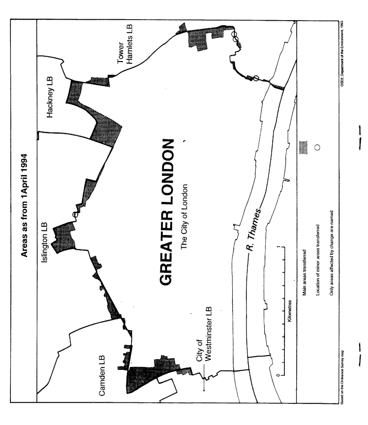
This Order makes changes to the boundary between the City of London and
(i)the London boroughs of Camden, Hackney, Islington, and Tower Hamlets;
(ii)the city of Westminister.
It also makes a minor consequential change to the boundary between Camden and Islington.
The map and table forming part of this Note (Pages 4 and 5) give a general guide to the changes made, and areas and population affected.
For full details of the transfers made, the order maps (described in article 2) should be inspected.
Any person may inspect them at any reasonable time at the offices of the council for each city or London borough affected, and also at the offices of the Secretary of State for the Environment, 2, Marsham Street, London SW1P 3EB.
Consequential changes are made to petty sessional areas, coroners' districts and to the Metropolitan Police District.
The Local Government Area Changes Regulations 1976 (S. I. 1976/246, amended by S. I. 1978/247) contain general provisions regarding the effect of orders such as this one.
TABLE
| Transfers | General description of changes— |
|---|---|
| Between Camden and the City (Article 3) Area: 15 hectares Population: 20 | Transfer to Camden of part of Holborn to the east of Grays Inn Road. Transfer to the City of area to the east of Chancery Lane, and south of High Holborn, including Chancery House, Southampton Buildings, and Staple Inn. Minor realignments to centre of road in Charterhouse Street, commencing at its junction with Holborn Viaduct, and terminating in the vicinity of Farringdon Road. |
| From Hackney to the City (Article 4) Area: 15 hectares Population: 0 | Transfer to the of part of the Broadgate City development, so that boundary follows the centre of Wilson Street, Sun Street, Appold Street and Worship Street. |
| Between the City and Islington (Article 5) Area: 10 hectares Population: 750 | Transfer to the City of parts of the Barbican complex and Golden Lane Estate, so that boundary follows centre of Goswell Road, Baltic Street and Golden Lane. Realignments in following areas— (a) Ropemaker Street/South Place; (b) Charterhouse Street, in vicinity of Smithfield Market; (c) Charterhouse Square/Barbican Station/Hayne Street; and (d) Prior Weston Primary School/Whitecross Street/Chiswell Street/Moor Lane (uniting Whitbread Brewery site in the City). |
| From Camden to Islington (Article 6) Area: less than 1 hectare Population: 0 | Minor realignment at junction of Farringdon Road and Charterhouse Street. |
| Between the City and Tower Hamlets (Article 7) Area: 15 hectares Population: 485 | Transfer to the City of area lying to the west of Mansell Street and to the east of the Minories. Realignments— (i) in Bishopsgate, between Primrose Street and Brushfield Street; (ii) to centre of Mansell Street, starting in the vicinity of Braham Street, and running south to Shorter Street; (iii) in vicinity of Shorter Street/Tower Hill/Tower Pier; and (iv) to centre of Fort Street, near the Bishopsgate Library. |
| Between the City and Westminster (Article 8) Area: 5 hectares Population: 0 | Transfer to the City of area to the east of Chancery Lane, running from Cursitor Street southwards to the southern side of the Public Record Office building. Transfer to Westminster of area located to the east of the Royal Courts of Justice, at the junction of Chancery Lane with Fleet Street. |