
Statutory Instruments
1993 No. 1277
LOCAL GOVERNMENT, ENGLAND AND WALES
CHANGES IN LOCAL GOVERNMENT AREAS
The Ealing, Hillingdon and Hounslow (London Borough Boundaries) Order 1993
Made
12th May 1993
Laid before Parliament
20th May 1993
Coming into force
for the purposes referred to in article 1(2)
1st December 1993
for all other purposes
1st April 1994
The Secretary of State, in exercise of his powers under sections 51(2) and 67(4) of the Local Government Act 1972(1) and of all other powers enabling him in that behalf, hereby makes the following Order which gives effect to proposals submitted to him under sections 47, 48(1) and 51(1) of that Act, more than six weeks before the making of this Order, by the Local Government Boundary Commission for England:
Citation and commencement
1.—(1) This Order may be cited as the Ealing, Hillingdon and Hounslow (London Borough Boundaries) Order 1993.
(2) This Order shall come into force on 1st December 1993 for any purpose set out in regulation 4(1) of the Local Government Area Changes Regulations 1976(2).
(3) For all other purposes, this Order shall come into force on 1st April 1994.
Interpretation
2.—(1) In this Orderany reference to Ealing, to Hillingdon or to Hounslow is a reference to the London borough of that name;
“the map” means one of the 5 maps prepared by the Department of the Environment, marked “Maps of the Ealing, Hillingdon and Hounslow (London Borough Boundaries) Order 1993”, and deposited in accordance with regulation 5 of the Local Government Area Changes Regulations 1976; and any reference to a ward is a reference to a ward of the London borough from or to which an area is transferred.
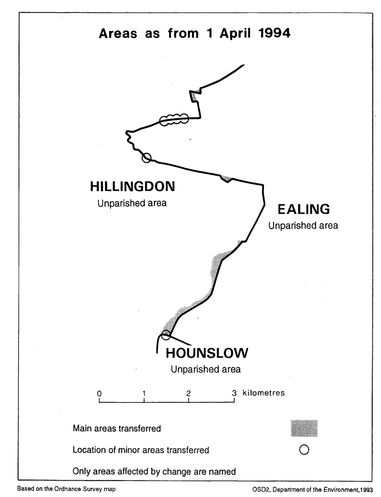
Transfers between Ealing and Hillingdon
3.—(1) Each area which is marked as shown in column 1 of the following Table on the map indicated in column 2 shall be transferred from Ealing, and from the ward named in column 3 to Hillingdon, to the ward named in column 4 and to the Hillingdon petty sessional area.
TABLE
| (1) | (2) | (3) | (4) |
|---|---|---|---|
| Area marked— | On map— | Transferred from Ealing, and from the following ward— | To Hillingdon, and to the following ward— |
| B | 1 | Glebe | Botwell |
| B | 5 | Mandeville | Bourne |
| D | 1 | Mount Pleasant | Yeading |
| A | 1 | Northcote | Townfield |
| B | 3 | West End | Barnhill |
| C & F | 5 | West End | Bourne |
(2) Each area which is marked as shown in column 1 of the following Table on the map indicated in column 2 shall be transferred from Hillingdon, from the ward named in column 3 to Ealing, to the ward named in column 4, and to the Ealing petty sessional area.
TABLE
| (1) | (2) | (3) | (4) |
|---|---|---|---|
| Area marked— | On map— | Transferred from Hillingdon, and from the following ward— | To Ealing and to the following ward— |
| A | 5 | Bourne | Mandeville |
A D, E & G | 4 5 | Bourne | West End |
| A | 3 | Charville | West End |
| B | 2 | Yeading | Ravenor |
| A | 2 | Yeading | West End |
Transfer from Hounslow to Hillingdon
4. The area which is marked C on map 1 shall be transferred from Hounslow, and from the Heston West ward to Hillingdon, to the Botwell ward, and to the Hillingdon petty sessional area.
Town and Country Planning
5.—(1) In this article, “provision” means a provision of a development plan (as defined in section 336(1) of the Town and Country Planning Act 1990(3).
(2) Any provision applying to an area transferred by this Order shall continue to apply to that area, notwithstanding the transfer, until replaced by a provision which so applies, and which is expressed to supersede the preserved provision.
Signed by authority of the Secretary of State for the Environment
Robin Squire
Parliamentary Under Secretary of State,
Department of the Environment
12th May 1993
Explanatory Note
(This note is not part of the Order)
This Order makes minor changes in the boundary of the London borough of Hillingdon with the London borough of Ealing, and with the London borough of Hounslow.
The map and table forming part of this Note give a general guide to the areas affected, and their size and population (in total).
For full details of the transfers made, the order maps (described in article 2) should be inspected.
Any person may inspect them at any reasonable time at the offices of the council for each London borough affected, and also at the offices of the Secretary of State for the Environment located in 2, Marsham Street, London SW1P 3EB.
Consequential changes are made to petty sessional divisions and coroners' districts.
No parishes are affected.
The Local Government Area Changes Regulations 1976 (S. I. 1976/246, amended by S. I. 1978/247) contain general provisions regarding the effect of orders such as this one.
TABLE
| Transfer(s) | Description of changes— |
|---|---|
| BETWEEN EALING AND HILLINGDON Article 3 Transferred from Hillingdon— Area: 5 hectares Population: 115 Transferred to Hillingdon— Area: 30 hectares Population: 275 | 1. Realignment of boundary between Bull’s Bridge and Spikes Bridge so that it follows the centre line of the Grand Union Canal (Paddington Branch) instead of Yeading Brook. This transfers warehouses, depots and some housing development off Uxbridge Road to Hillingdon. 2. Transfers to unite Aircraft Estate in Ealing, affecting Wayfarer Road, Viscount Grove and Dove Close. 3. Minor realignment in Kingshill Avenue at the bridge over Yeading Brook. 4. Minor realignment to more defined boundary in Sharvel Lane, north of the West London Shooting Grounds. 5. Realignments to unite Sports Complex and Grounds off West End Road/Harvey Road in Ealing, and to establish a clearer boundary across Western Avenue north of the Grounds. |
| FROM HOUNSLOW TO HILLINGDON Article 4 Area: 1 hectare Population: Nil | Minor realignment at Bull’s Bridge as a consequence of the changes effected by article 3. |
1990 c. 8. This definition was amended by the Planning and Compensation Act 1991 (c. 34), Schedule 4, paragraph 34.