
Statutory Instruments
1993 No. 1148
LOCAL GOVERNMENT, ENGLAND AND WALES
CHANGES IN LOCAL GOVERNMENT AREAS
The Greater London and Surrey (County and London Borough Boundaries) Order 1993
Made
23rd April 1993
Laid before Parliament
4th May 1993
Coming into force
for the purposes referred to in article 1(2)
1st December 1993
for all other purposes
1st April 1994
The Secretary of State, in exercise of his powers under sections 51(2) and 67(4) of the Local Government Act 1972(1) and of all other powers enabling him in that behalf, hereby makes the following Order which gives effect to proposals submitted to him under sections 47, 48(1) and 51(1) of that Act, more than six weeks before the making of this Order, by the Local Government Boundary Commission for England:
Citation and commencement
1.—(1) This Order may be cited as the Greater London and Surrey (County and London Borough Boundaries) Order 1993.
(2) This Order shall come into force on 1st December 1993 for any purpose set out in regulation 4(1) of the Local Government Area Changes Regulations 1976(2).
(3) For all other purposes, this Order shall come into force on 1st April 1994.
Interpretation
2. In this Order—
“Bromley” means the London borough of Bromley;
“Croydon” means the London borough of Croydon;
“district” includes a borough and a London borough;
“electoral division” means an electoral division of the county of Surrey;
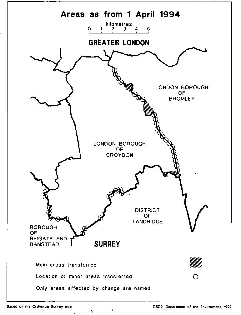
“the map” means one or more of the 19 maps prepared by the Department of the Environment, marked “Maps of the Greater London and Surrey (County and London Borough Boundaries) Order 1993”, and deposited in accordance with regulation 5 of the Local Government Area Changes Regulations 1976;
“Reigate” means the Surrey borough of Reigate and Banstead;
“Surrey” means the county of Surrey;
“Tandridge” means the Surrey district of Tandridge; any reference to an area as unparished is a reference to that area not forming part of any parish; and
“ward” means a district ward.
Transfers from Greater London (Croydon) to Surrey (Reigate and Tandridge)
3.—(1) Each area which is marked as shown in column 1 of the following Table on the map indicated in column 2 shall be transferred from Greater London, from Croydon and from the Croydon ward named in column 3 to—
(a)Surrey;
(b)the district mentioned in column 4;
(c)the ward, electoral division and petty sessional division so mentioned; and to
(d)the Surrey coroner’s district
and shall remain unparished.
TABLE
| (1) | (2) | (3) | (4) |
|---|---|---|---|
| Area marked— | On map | Transferred from Greater London, from Croydon, and from the following ward of Croydon | To Surrey, and to— |
| A, C, E & G | 19 | Woodcote and | Reigate |
A, C, E & F A | 18 17 | Coulsdon West | Chipstead-Hooley and Woodmansterne ward |
| B & D | 16 | Coulsdon East | Banstead East electoral division North & East Surrey petty sessional division |
| B | 15 | Coulsdon East | Tandridge Chaldon ward Caterham Hill electoral division South East Surrey petty sessional division |
| A | 14 | Kenley | Tandridge Portley ward Caterham Hill electoral division South East Surrey petty sessional division |
B G | 11 12 | Sanderstead | Tandridge Warlingham West ward Warlingham electoral division South East Surrey petty sessional division |
| C & D | 15 | Coulsdon East | Tandridge Westway ward Caterham Hill electoral division South East Surrey petty sessional division |
| B | 12 & 13 | Kenley | Tandridge Whyteleafe ward |
F D | 12 13 | Sanderstead | Caterham Valley electoral division South East Surrey petty sessional division |
(2) The areas markedB on map 11;D on map 13; F & G on map 12;A on map 14; and B on maps 12 and 13;B, C and D on map 15shall cease to form part of the Metropolitan Police District. Transfers from Surrey (Reigate and Tandridge) to Greater London (Croydon)
4.—(1) Each area which is marked as shown in column 1 of the following Table on the map indicated in column 2 shall be transferred from Surrey, from the district, from the ward, and from the parish (if any) named in column 3 to—
(a)Greater London;
(b)Croydon;
(c)the Croydon ward mentioned in column 4;
(d)the Croydon petty sessional division and the Southern London coroner’s district;
and shall become or remain unparished.
TABLE
| (1) | (2) | (3) | (4) |
|---|---|---|---|
| Area marked | On map | Transferred from Surrey, and from— | To Greater London, to Croydon, and to the following ward— |
| A & C | 16 | Reigate Chipstead-Hooley and Woodmansterne ward | Coulsdon East |
B, D & F B & D B | 19 18 17 | Reigate Chipstead-Hooley and Woodmansterne ward Woodcote and Coulsdon West | |
| A & B | 9 | Chelsham and Farleigh, Tatsfield and Titsey ward Parish of Chelsham and Farleigh Tandridge | Heathfield |
| C | 9 | Tandridge Chelsham and Farleigh, Tatsfield and Titsey ward Parish of Chelsham and Farleigh | New Addington |
| A | 15 | Tandridge Chaldon ward | Coulsdon East |
| A12 | Tandridge Whyteleafe ward | Kenley | |
| Tandridge | Sanderstead | ||
| E | 12 & 13 | Whyteleafe ward | |
| A | 11 | Warlingham West | |
| A | 10 | Warlingham East | |
| B | 10 |
(2) The areas marked—
A, B and C on map 9;
A and B on map 10;
A on map 11;
A on map 12;
E on maps 12 and 13;and
A on map 15
shall additionally be transferred to the Metropolitan Police District.
Transfers within Greater London between Bromley and Croydon
5.—(1) Each area which is marked as shown in column 1 of the following Table on the map indicated in column 2 shall be transferred from Bromley, and from the Bromley ward named in column 3 to Croydon, to the Croydon ward mentioned in column 4, and to the Croydon petty sessional division.
TABLE
| (1) | (2) | (3) | (4) |
|---|---|---|---|
| Area marked | On map | Transferred from Bromley, and from the following ward— | To Croydon, and to the following ward— |
| B | 1 | Anerley | South Norwood |
| D | 9 | Biggin Hill | New Addington |
| A & D2 | Clock House | Rylands | |
| F | 9 | Darwin | New Addington |
| A | 8 | C & E | 7 |
| C | 3 | Eden Park | Monks Orchard |
| B | 4 | ||
| E & G | 2 | ||
| F | 6 | West Wickham South | Fieldway |
| C & E | 6 | West Wickham South | Heathfield |
| F & G | 7 | West Wickham South | New Addington |
| E | 6 | ||
| D & F | 5 | West Wickham South | Spring Park |
(2) Each area which is marked as shown in column 1 of the following Table on the map indicated in column 2 shall be transferred from Croydon, and from the Croydon ward named in column 3 to Bromley, to the Bromley ward mentioned in column 4, and to the Bromley petty sessional division.
TABLE
| (1) | (2) | (3) | (4) |
|---|---|---|---|
| Area marked | On map | Transferred from Croydon, and from the following ward | To Bromley, and to the following ward |
| A, G & H | 6 | Fieldway | West Wickham South |
| A | 5 | Heathfield | West Wickham South |
| B & D | 6 | ||
| A | 4 | Monks Orchard | Eden Park |
| F | 2 | ||
| D | 4 | Monks Orchard | West Wickham North |
| E | 9 | New Addington | Darwin |
| B & D | 7 | ||
| J | 6 | New Addington | West Wickham South |
| B | 2 | Rylands | Clock House |
| A | 1 | South Norwood | Anerley |
| C | 1 & 2 | ||
| B, E, C & G | 5 | Spring Park | West Wickham South |
| E & F | 4 |
(3) All areas transferred by this article shall remain unparished.
Consequential ward changes within Croydon
6. The boundaries of wards in Croydon shall be altered as follows—
(a)the part of the Kenley ward marked C on map 13 shall be transferred to the Sanderstead ward; and
(b)the part of Monks Orchard ward marked C on map 4 shall be transferred to the Spring Park ward.
Town and country planning
7.—(1) In this article, “provision” means a provision of a development plan (as defined in section 336(1) of the Town and Country Planning Act 1990(3)).
(2) Any provision applying to an area transferred by this Order shall continue to apply to that area, notwithstanding the transfer, until replaced by a provision which so applies, and which is expressed to supersede the preserved provision.
Application of the Local Government Area Changes Regulations-Chipstead Valley Primary School
8. Notwithstanding the transfer of area G on map 19 from Greater London, and from Croydon to Surrey and to Reigate, regulation 62 (Property, liabilities, contracts, etc., notices and proceedings) of the Local Government Area Changes Regulations 1976 shall not apply to the Chipstead Valley Primary School or to any part of its site.
Signed by authority of the Secretary of State for the Environment
Robin Squire
Parliamentary Under Secretary of State,
Department of the Environment
23rd April 1993
Explanatory Note
(This note is not part of the Order)
This Order transfers areas between the counties of Greater London and Surrey, affecting the boundaries of the London borough of Croydon with the borough of Reigate and Banstead and with the district of Tandridge.
Changes are also made in the boundary between the London boroughs of Bromley and Croydon. Consequential alterations are made to the boundaries of local government electoral areas, of petty sessional divisions, of coroners' districts, and of the Metropolitan Police District.
Many of the transfers effected are small, consisting of minor realignments.
The larger transfers are described in the Table at the end of this Note, which also gives in approximate terms the total area (hectares) and population affected by each set of transfers. The Table is a general guide only to the areas affected, and the maps mentioned in article 2 should be inspected for full details of all transfers. Any person may inspect the maps at any reasonable time at the offices of the council for each borough or district affected, and additionally at the offices of the Secretary of State for the Environment located in 2, Marsham Street, London SW1P 3EB.
The Local Government Area Changes Regulations 1976 contain general provisions regarding the effect of orders such as this one. A special provision in the Order excludes Chipstead Valley Primary School from the usual rules relating to property transfer (which are contained in regulation 62).
| Transfers | Total area and population affected and description of major changes in boundaries |
|---|---|
| Greater | 17 hectares 230 population |
| London to Surrey | 1. Realignment in area east of Rickman Hill Road to follow line of |
| Portnalls Road. Article 3 | 2. Transfer of area west of Woodplace Lane, to unite Woodplace Farm in Reigate. |
| Croydon to Reigate | |
| Croydon to Tandridge | 1. Realignment along the eastern side of bridleway in Broad Wood. |
2. Transfer of area comprising Anson Close and Gauntlet Crescent. 3. Transfer in Godstone Road area of Gasholder Station and Welcome Terrace. | |
| 30 hectares 540 population | |
| Transfers from Surrey (Reigate and Tandridge) to Greater London (Croydon) Article 4 | 1. Transfer of parts of Fairchildes Junior and High Schools, New Addington |
2. Transfer of large area north of Tithepit Shaw Lane, including Princes Avenue, and parts of Wentworth Way, Clyde Avenue and Limpsfield Road. | |
| 110 hectares 870 population | |
| Transfers within London between Bromley and Croydon Article 5. | 1. Transfer to Croydon in the vicinity of Ash Tree Close, Fairway Close and Fairford Close. 2. Transfer to Croydon of large area of South Norwood Park to the south of Beckenham Crematorium. 3. Realignment east of Fairchildes High School to follow line of King Henry’s Drive and Skidhill Lane. 4. Transfer to Bromley of the Briar Lane area north of Inchwood. 5. Transfer placing Pond Lane Caravan Park and the Bethlem Royal Hospital wholly 6. Transfer to Bromley of area in the vicinity of Cambridge Road, Penge Road and Selby Road. |
S.I. 1976/246, amended by S.I. 1978/247.
1990 c. 8. This definition was amended by the Planning and Compensation Act 1991 (c. 34), Schedule 4, paragraph 34.