1992 No. 2093
The Surrey and West Sussex (County Boundaries) Order 1992
Made
Laid before Parliament
Coming into force
for the purposes referred to in article 1(2)
for all other purposes
The Secretary of State, in exercise of his powers under section 51(2) and 67(4) of the Local Government Act 19721 and of all other powers enabling him in that behalf, hereby makes the following Order which gives effect to proposals submitted to him under sections 47, 48(1) and 51(1) of that Act, more than six weeks before the making of this Order by the Local Government Boundary Commission for England:
Citation and commencement1
1
This Order may be cited as the Surrey and West Sussex (County Boundaries) Order 1992.
2
This Order shall come into force on 29th September 1992 for any purpose set out in regulation 4(1) of the Local Government Area Changes Regulations 19762.
3
For all other purposes, this Order shall come into force on 1st April 1993.
Interpretation2
In this Order—
“district” means a borough or district;
“electoral division” means an electoral division of the county to which an area is transferred;
“the map” means one or more of the 12 maps prepared by the Department of the Environment, marked “Maps of the Surrey and West Sussex (County Boundaries) Order 1992”, and deposited in accordance with regulation 5 of the Local Government Area Changes Regulations 1976;
“parish” includes a town;
“Surrey” means the county of Surrey, and any reference to Mole Valley, to Reigate and Banstead, to Tandridge or to Waverley is a reference to the Surrey district of that name;
any reference to an area as “unparished” is a reference to that area not forming part of any parish; and
“ward” means a ward of the district to which an area is transferred; and
“West Sussex” means the county of West Sussex, and any reference to Chichester, to Crawley, to Horsham or to Mid Sussex is a reference to the West Sussex district of that name.
Transfers from Surrey to West Sussex3
Each area marked as shown in column 1 of the following Table on the map indicated in column 2 shall be transferred from Surrey and from the district and parish named in column 3 to—
a
West Sussex;
b
the district and the parish (if any) mentioned in column 4;
c
the ward, electoral division and petty sessional division so mentioned; and to
d
the West Sussex coroner’s district.
(1) | (2) | (3) | (4) |
|---|---|---|---|
Area marked | On map | Transferred from | To— |
A31, A32, A33 and A34 | 8 | Mole Valley Parish of Abinger | Horsham Parish of Rudgwick Rudgwick ward Warnham electoral division Horsham petty sessional division |
A35 | 9 | Mole Valley Parish of Capel | Horsham Parish of Rusper Rusper ward Holbrook electoral division Horsham petty sessional division |
B1 | 10 | Tandridge Parish of Burstow | Crawley Unparished Pound Hill North ward Pound Hill electoral division Crawley petty sessional division |
A36 and A37 | 10 | Tandridge Parish of Burstow | Mid Sussex Parish of Worth Copthorne and Worth ward Mid Sussex North electoral division Mid Sussex petty sessional division |
A39 A40 | 11 12 | Tandridge Parish of Lingfield | Mid Sussex Parish of East Grinstead East Grinstead North ward East Grinstead East electoral division Mid Sussex petty sessional division |
A38 | 11 | Tandridge Parish of Lingfield | Mid Sussex Parish of East Grinstead East Grinstead West ward Imberdown electoral division Mid Sussex petty sessional division |
A21, A22, A23 and A24 | 6 | Waverley Parish of Alfold | Chichester Parish of Loxwood Plaistow ward Petworth electoral division Chichester and District petty sessional division |
A25 | 7 | Waverley Parish of Cranleigh | Horsham Parish of Rudgwick Rudgwick ward Warnham electoral division Horsham petty sessional division |
A26 | 7 | Waverley Parish of Ewhurst | Horsham Parish of Rudgwick Rudgwick ward Warnham electoral division Horsham petty sessional division |
A16, A17 and A18 | 3 | Waverley Parish of Haslemere | Chichester Parish of Fernhurst Fernhurst ward Fernhurst electoral division Chichester and District petty sessional division |
A19 and A20 | 2 | Waverley Parish of Haslemere | Chichester Parish of Lurgashall Lodsworth ward Fernhurst electoral division Chichester and District petty sessional division |
Transfers from West Sussex to Surrey4
Each area marked as shown in column 1 of the following Table shall be transferred from West Sussex, and from the district and the parish (if any) named in column 3 to—
a
Surrey;
b
the district and the parish mentioned in column 4;
c
the ward, electoral division and petty sessional division so mentioned; and to
d
the Surrey coroner’s district.
(1) | (2) | (3) | (4) |
|---|---|---|---|
Area marked | On map | Transferred from | To— |
A7, A8 and A9 | 3 | Chichester Parish of Fernhurst | Waverley Parish of Haslemere Haslemere South ward Haslemere electoral division Farnham petty sessional division |
A1, A2, A3, A4, A5 and A6 | 1 | Chichester Parish of Linchmere | Waverley Parish of Haslemere Shottermill ward Haslemere electoral division Farnham petty sessional division |
A13, A14 and A15 | 6 | Chichester Parish of Loxwood | Waverley Parish of Alfold Alfold and Dunsfold ward Godalming South and Rural electoral division Guildford petty sessional division |
A11 | 4 | Chichester Parish of Lurgashall | Waverley Parish of Chiddingfold Chiddingfold ward Godalming South and Rural electoral division Guildford petty sessional division |
A10 | 2 | Chichester Parish of Lurgashall | Waverley Parish of Haslemere Haslemere South ward Haslemere electoral division Farnham petty sessional division |
A12 | 5 | Chichester Parish of Plaistow | Waverley Parish of Dunsfold Alfold and Dunsfold ward Godalming South and Rural electoral division Guildford petty sessional division |
C1 | 10 | Crawley Unparished | Reigate and Banstead Parish of Horley Horley East ward Horley East and Salfords electoral division Reigate petty sessional division |
A27, A28, A29 and A30 | 8 | Horsham Parish of Rudgwick | Mole Valley Parish of Abinger Okewood ward Dorking Rural electoral division Dorking petty sessional division |
Town and country planning5
1
In this article, “provision” means a provision of a development plan as defined in section 336 of the Town and Country Planning Act 19903.
2
Any provision applying to an area transferred by this Order shall continue to apply to that area, notwithstanding the transfer, until replaced by a provision which so applies, and which is expressed to supersede the preserved provision.
Signed by authority of the Secretary of State for the Environment
(This note is not part of the Order)
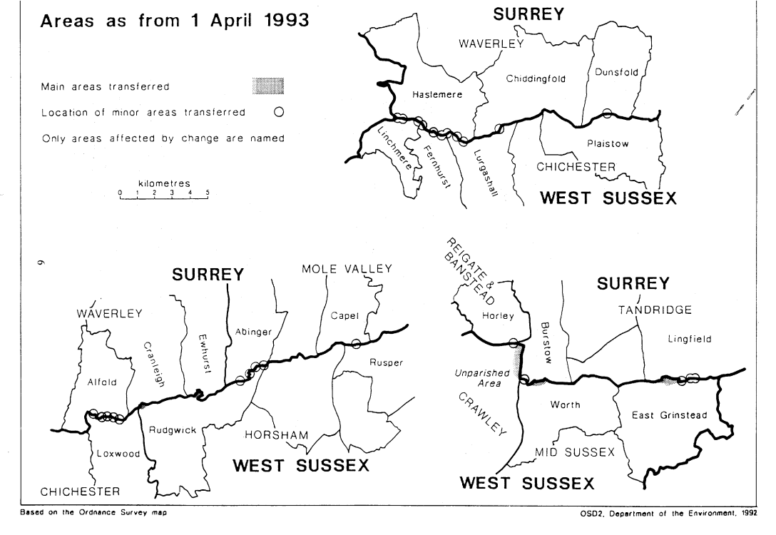
This Order transfers areas between the counties of Surrey and West Sussex, affecting the boundaries of the districts of Chichester, Crawley, Horsham, Mid Sussex, Mole Valley, Reigate and Banstead, Tandridge and Waverley. Consequential changes are made to local government electoral areas, petty sessional divisions and coroners' districts.
The map and table forming part of this note (Pages 5 and 6) give a general guide to the location of areas transferred. Prints of the detailed order maps (described in article 2) may be inspected at all reasonable times at the offices of each district council whose area is affected, and at the offices of the Secretary of State for the Environment in 2 Marsham Street, London SW1P 3EB.
In approximate terms, the land transferred from Surrey to West Sussex has a total area of 180 hectares and a population of 1780, and that transferred from West Sussex to Surrey has a total area of 16 hectares and a population of 7.
The Local Government Area Changes Regulations 1976 (S.I.1976/246, amended by S.I.1978/247) contain general provisions regarding the effect of orders such as this one.
Transfers from Surrey to West Sussex | Transfer of large area from Burstow to Crawley (including parts of the M23 motorway), starting immediately south of Peeks Rough Farm, and running southwards through Fernhill and Shipley Bridge, terminating to the north-east of Black Corner. Transfer from Burstow to Worth of largely residential area lying to the north of Copthorne and to the south of Stonelands Farm, including Roffey’s Close and parts of Copthorne Bank and Church Road. Transfer from Lingfield to East Grinstead of area north of Lowdell’s Lane, starting to the west of Lowerbarn Farm and terminating near Spring Copse (and including Portefield Road and Wells Bottom, and parts of Hermitage Road and Lingfield Road). Transfer of area including Rikkyo School and nearby fields. Transfer from Ewhurst to Rudgwick of area including part of the B2128 road, starting at Cox Green and running south to vicinity of Duke’s Farm. Transfer from Haslemere to Fernhurst of area including part of Bell Vale Lane, Stedlands Farm and Little Stedlands. |
Transfers from West Sussex to Surrey | Transfer from Lurgashall to Haslemere of area south of Chase Lane, including Chase Farm. |
Realignments in the following areas— |
|