This Order supersedes S.I. 1990/584 published on 22nd March 1990 and is being issued free of charge to all known recipients of that Statutory Instrument.
Statutory Instruments
1990 No. 882 (S.115)
LOCAL GOVERNMENT, SCOTLAND
CHANGES IN LOCAL GOVERNMENT AREAS
The Renfrew and City of Glasgow Districts (Atholl Crescent, Southwold Road, Rosshall, Bullwood and Hurlet) Boundaries Amendment (No. 2) Order 1990
Made
6th April 1990
Laid before Parliament
10th April 1990
Coming into force
15th April 1990
Whereas under section 17(1) of the Local Government (Scotland) Act 1973(1) the Local Government Boundary Commission for Scotland on 22nd May 1989 submitted to the Secretary of State a report on a review conducted under section 14(1) of that Act in which they made proposals for the transfer of certain areas between Renfrew District and the City of Glasgow District in Strathclyde Region, and in which they also made proposals for changes in electoral arrangements consequential on those changes in local government areas;
And whereas the Secretary of State purported to give effect to the proposals of the Local Government Boundary Commission for Scotland in the Renfrew and City of Glasgow Districts (Atholl Crescent, Southwold Road, Rosshall, Bullwood and Hurlet) Boundaries Amendment Order 1990(2) which is due to come into force on 15th April 1990 but it has since been discovered that that Order did not give proper effect to those proposals;
Now, therefore, in exercise of the powers conferred on him by sections 17(2) and 233(2) of the said Act, and of all other powers enabling him in that behalf, the Secretary of State hereby makes the following Order to give effect to the proposals of the Local Government Boundary Commission for Scotland as submitted to him:
Citation and commencement
1. This Order may be cited as the Renfrew and City of Glasgow Districts (Atholl Crescent, Southwold Road, Rosshall, Bullwood and Hurlet) Boundaries Amendment (No. 2) Order 1990 and shall come into force on 15th April 1990.
Interpretation
2. In this Order–
“the 1977 Regulations” means the Local Government Area Changes (Scotland) Regulations 1977(3);
“the 1990 Order” means the Renfrew and City of Glasgow Districts (Atholl Crescent, Southwold Road, Rosshall, Bullwood and Hurlet) Boundaries Amendment Order 1990;
“boundary map 1” means the map prepared by the Scottish Office marked “The Renfrew and City of Glasgow Districts (Atholl Crescent, Southwold Road, Rosshall, Bullwood and Hurlet) Boundaries Amendment (No. 2) Order 1990 Map 1” and deposited in accordance with regulation 3 of the 1977 Regulations;
“boundary map 2” means the map prepared by the Scottish Office marked “The Renfrew and City of Glasgow Districts (Atholl Crescent, Southwold Road, Rosshall, Bullwood and Hurlet) Boundaries Amendment (No. 2) Order 1990 Map 2” and deposited in accordance with regulation 3 of the 1977 Regulations;
“boundary map 3” means the map prepared by the Scottish Office marked “The Renfrew and City of Glasgow Districts (Atholl Crescent, Southwold Road, Rosshall, Bullwood and Hurlet) Boundaries Amendment (No. 2) Order 1990 Map 3” and deposited in accordance with regulation 3 of the 1977 Regulations;
“boundary map 4” means the map prepared by the Scottish Office marked “The Renfrew and City of Glasgow Districts (Atholl Crescent, Southwold Road, Rosshall, Bullwood and Hurlet) Boundaries Amendment (No. 2) Order 1990 Map 4” and deposited in accordance with regulation 3 of the 1977 Regulations;
“boundary map 4a” means the map prepared by the Scottish Office marked “The Renfrew and City of Glasgow Districts (Atholl Crescent, Southwold Road, Rosshall, Bullwood and Hurlet) Boundaries Amendment (No. 2) Order 1990 Map 4a” and deposited in accordance with regulation 3 of the 1977 Regulations;
and, in the Schedule to this Order, any reference to a boundary of a district is a reference to a boundary existing immediately before the commencement of this Order.
Application of the 1977 Regulations
3. Save insofar as they can have no application in relation to the area changes effected by this Order, the provisions of the 1977 Regulations shall apply in relation thereto for the purposes of, or in consequence of, this Order.
Area changes
4.—(1) Those parts of the City of Glasgow District, being the areas described in Part I of the Schedule to this Order, namely:–
(a)the areas A, C and D which areas are shown delineated, hatched and marked “Area A”, “Area C” and “Area D” respectively on Boundary Map 1;
(b)the areas E, G, H and K which areas are shown delineated, hatched and marked “Area E”, “Area G”, “Area H” and “Area K” respectively on Boundary Map 2; and
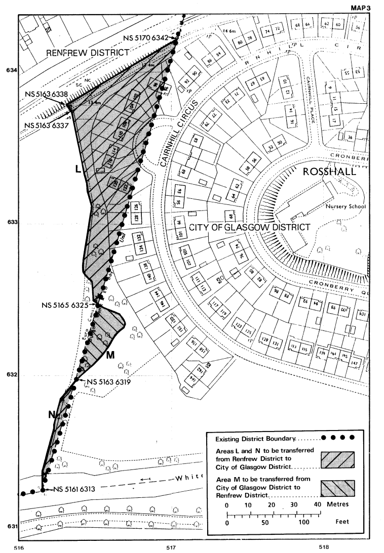
(c)the area M which is shown delineated, hatched and marked “Area M” on Boundary Map 3;
shall all be transferred to Renfrew District.
(2) Those parts of Renfrew District, being the areas described in Part II of the Schedule to this Order, namely–
(a)the area B which area is shown delineated, hatched and marked “Area B” on Boundary Map 1;
(b)the areas F and J which areas are delineated, hatched and marked “Area F” and “Area J” respectively on Boundary Map 2; and
(c)the areas L and N which areas are delineated, hatched and marked “Area L” and “Area N” respectively on Boundary Map 3;
shall all be transferred to the City of Glasgow District.
(3) Those parts of the City of Glasgow District, being the areas O and Q described in Part I of the Schedule to this Order and shown delineated, hatched and marked “Area O” on boundary map 4 and “Area Q” on boundary map 4a respectively, shall be transferred to Renfrew District.
(4) Part of Renfrew District, being the area P described in Part II of the Schedule to this Order and shown delineated, hatched and marked “Area P” on boundary map 4a, shall be transferred to the City of Glasgow District.
(5) Part of the City of Glasgow District, being the area S described in Part I of the Schedule to this Order and shown delineated, hatched and marked “Area S” on boundary map 4a, shall be transferred to Renfrew District.
Consequential changes of electoral arrangements
5.—(1) Each of the areas A, C, D, E, G, H, K and M described in Part I of the Schedule to this Order (being the areas transferred by article 4(1)(a) to (c) of this Order)–
(a)shall cease to form part of electoral division 29 (Penilee/Cardonald) of Strathclyde Region(4) and of ward 41 (Penilee) of the City of Glasgow District(5); and
(b)shall form part of electoral division 78 (Paisley Abercorn) of Strathclyde Region and of ward 20 (Ralston) of Renfrew District(6).
(2) Each of the areas B, F, J, L and N described in Part II of the Schedule to this Order (being the areas transferred by article 4(2)(a) to (c) of this Order)–
(a)shall cease to form part of electoral division 78 (Paisley Abercorn) of Strathclyde Region and of ward 20 (Ralston) of Renfrew District; and
(b)shall form part of electoral division 29 (Penilee/Cardonald) of Strathclyde Region and of ward 41 (Penilee) of the City of Glasgow District.
(3) Each of the areas O and Q described in Part I of the Schedule to this Order (being the areas transferred by article 4(3) of this Order) –
(a)shall cease to form part of electoral division 31 (Crookston/Cowglen) of Strathclyde Region and of ward 46 (Cowglen) of the City of Glasgow District; and
(b)shall form part of electoral division 77 (Paisley Central) of Strathclyde Region and of ward 13 (Hawkhead) of Renfrew District.
(4) Area P described in Part II of the Schedule to this Order (being the area transferred by article 4(4) of this Order)–
(a)shall cease to form part of electoral division 77 (Paisley Central) of Strathclyde Region and of ward 13 (Hawkhead) of Renfrew District; and
(b)shall form part of electoral division 31 (Crookston/Cowglen) of Strathclyde Region and of ward 46 (Cowglen) of the City of Glasgow District.
(5) Area S described in Part I of the Schedule to this Order (being the area transferred by article 4(5) of this Order)–
(a)shall cease to form part of electoral division 32 (South Nitshill/Arden) of Strathclyde Region and of ward 47 (South Nitshill) of the City of Glasgow District; and
(b)shall form part of electoral division 77 (Paisley Central) of Strathclyde Region and of ward 13 (Hawkhead) of Renfrew District.
(6) Area R shown delineated, cross-hatched and marked “Area R” on Boundary Map 4a and described in Part III of the Schedule to this Order–
(a)shall cease to form part of electoral division 32 (South Nitshill/Arden) of Strathclyde Region and of ward 47 (South Nitshill) of the City of Glasgow District; and
(b)shall form part of electoral division 31 (Crookston/Cowglen) of Strathclyde Region and of ward 46 (Cowglen) of the City of Glasgow District.
Revocation
6. The 1990 Order is hereby revoked.
James Douglas-Hamilton
Parliamentary Under Secretary of State, Scottish Office
St. Andrew’s House,
Edinburgh
6th April 1990
Articles 2, 4 and 5
SCHEDULE
PART I
Area A
The area bounded by a line commencing on the City of Glasgow/Renfrew district boundary at a point grid reference NS 5111 6454, northeastwards, then southeastwards, along a fence line bounding the rear curtilage of properties at 1-61 Atholl Crescent, to rejoin the said district boundary at a point grid reference NS 5139 6454; then northwestwards and southwestwards along that boundary to the point of commencement.
Area C
The area bounded by a line commencing on the City of Glasgow/Renfrew district boundary at a point grid reference NS 5144 6446, southeastwards along a fence line bounding the rear curtilage of properties at 41-47 Craigmuir Road, to a point being the southeastern corner of the fence bounding the rear curtilage of property at 41 Craigmuir Road, southeastwards then southwards along the western curtilage boundary of properties at 101-111 Selvieland Road to rejoin the said district boundary at a point grid reference NS 5147 6444; then northwestwards along that boundary to the point of commencement.
Area D
The area bounded by a line commencing on the City of Glasgow/Renfrew district boundary at a point grid reference NS 5145 6432, southwestwards along a fence line bounding the rear curtilage of properties at 28-38 Buchlyvie Road, to rejoin the said district boundary at a point grid reference NS 5141 6426; then northwestwards and northeastwards along that boundary to the point of commencement.
Area E
The area bounded by a line commencing on the City of Glasgow/Renfrew district boundary at a point grid reference NS 5161 6411, southeastwards and thereafter southwestwards along a wall which forms the northern and thereafter eastern boundary of the curtilage of property at 6 Gartartan Road to rejoin the said district boundary at a point grid reference NS 5164 6406; then northwestwards and northeastwards along that boundary to the point of commencement.
Area G
The area bounded by a line commencing on the City of Glasgow/Renfrew district boundary at a point grid reference NS 5173 6407, northwestwards then generally northeastwards and southeastwards along a wall and fence line bounding the rear curtilage of properties at 9-15 Ossian Avenue, to a point grid reference NS 5176 6407 on the said district boundary; then generally westwards along that boundary to the point of commencement.
Area H
The area bounded by a line commencing on the City of Glasgow/Renfrew district boundary at a point grid reference NS 5176 6407, northeastwards along a wall and fence line bounding the northern curtilage of the property at 16 Ossian Avenue; then southeastwards along a wall and fence line on the west side of Kelhead Avenue to a point grid reference NS 5179 6407 on the said district boundary; then westwards along that boundary to the point of commencement.
Area K
The area bounded by a line commencing on the City of Glasgow/Renfrew district boundary at a point grid reference NS 5180 6401, southeastwards by wall and fence line along the west side of Kelhead Avenue to a point grid reference NS 5183 6389; thereafter southwestwards in a straight line to a point grid reference NS 5182 6386 on the south side of Paisley Road West; then northwestwards along the south side of that road to a point grid reference NS 5178 6387; then southwestwards along a wall and fence line bounding the rear curtilage of properties at 3-103 Ralston Drive to rejoin the said district boundary at a point grid reference NS 5173 6364; then northeastwards along that boundary to the point of commencement.
Area M
The area bounded by a line commencing on the City of Glasgow/Renfrew district boundary at a point grid reference NS 5165 6325, southeastwards then southwestwards along the course of a burn to its intersection with the said district boundary at a point grid reference NS 5163 6319; then northeastwards along that boundary to the point of commencement.
Area O
The area bounded by a line commencing on the City of Glasgow/Renfrew district boundary on the north side of the access track leading from Hurlet Road to Hawkhead House Farm at a point grid reference NS 5110 6206; then southeastwards and southwestwards along the east side of that track to a point grid reference NS 5095 6149 where it joins Hurlet Road; thereafter in a straight line southwestwards across Hurlet Road to its southern boundary at a point grid reference NS 5091 6144; thereafter southeastwards along the south side of Hurlet Road to a point grid reference NS 5147 6092; then in a straight line across the mouth of Barrhead Road to a point grid reference NS 5151 6091 on the said district boundary; then southwestwards, northwestwards and northeastwards along that boundary to the point of commencement.
Area Q
The area bounded by a line commencing on the City of Glasgow/Renfrew district boundary at a point grid reference NS 5158 6091; generally southeastwards along the south side of Nitshill Road to a point where it joins the boundary between Electoral Division 32 and Electoral Division 31 grid reference NS 5167 6086; then southwestwards along that Electoral Division boundary to rejoin the said district boundary at a point grid reference NS 5167 6084; thereafter northwestwards along that boundary to the point of commencement.
Area S
The area bounded by a line commencing on the City of Glasgow/Renfrew district boundary at a point grid reference NS 5167 6084, northeastwards along the boundary between Electoral Division 32 and Electoral Division 31 to a point grid reference NS 5167 6086 on the south side of Nitshill Road; then southeastwards along the south side of Nitshill Road to a point at Levern Bridge, grid reference NS 5176 6081; then generally southwestwards along the centre line of the Levern Water to rejoin the said district boundary at a point grid reference NS 5170 6062; then northwestwards and northeastwards along that boundary to the point of commencement.
PART II
Area B
The area bounded by a line commencing on the City of Glasgow/Renfrew district boundary at a point grid reference NS 5139 6454, southeastwards along a fence line bounding the rear curtilage of properties at 63-69 Atholl Crescent and at 74-86 Buchlyvie Road, to rejoin the said district boundary at a point grid reference NS 5144 6446; then northwestwards along that boundary to the point of commencement.
Area F
The area bounded by a line commencing on the City of Glasgow/Renfrew district boundary at a point grid reference NS 5166 6405, southeastwards along a wall and fence line bounding the rear curtilage of properties at 34-36 Auchmannoch Avenue to a point grid reference NS 5169 6403; then northeastwards by wall and fence line bounding the rear curtilage of properties at 1-3 Ossian Avenue to a point grid reference NS 5169 6406; then northeastwards and northwestwards by a wall and fence line bounding the rear curtilage of properties at 5-9 Ossian Avenue to rejoin the said district boundary at a point grid reference NS 5173 6407; then southwestwards along that boundary to the point of commencement.
Area J
The area bounded by a line commencing on the City of Glasgow/Renfrew district boundary at a point grid reference NS 5179 6407, southeastwards by boundary wall and fence line along the west side of Kelhead Avenue to a point grid reference NS 5180 6401 on the said district boundary; then northeastwards and westwards along that boundary to the point of commencement.
Area L
The area bounded by a line on the City of Glasgow/Renfrew district boundary at a point grid reference NS 5170 6342, southwestwards by fence line to a point grid reference NS 5163 6338; then southeastwards across an unmetalled road (running between Rosshall Mains and Cairnhall Circus, Rosshall) to a point on a fence line grid reference NS 5163 6337; thereafter generally southwards along a burn to where it intersects with the said boundary at a point grid reference NS 5165 6325; then northeastwards along that boundary to the point of commencement.
Area N
The area bounded by a line commencing on the City of Glasgow/Renfrew district boundary at a point grid reference NS 5163 6319, southwestwards along the course of a burn to the White Cart Water so far as to rejoin the said district boundary at a point grid reference NS 5161 6313; then northeastwards along that boundary to the point of commencement.
Area P
The area bounded by a line commencing on the City of Glasgow/Renfrew district boundary at a point grid reference NS 5155 6091, southeastwards by a wall to a point grid reference NS 5156 6090; then northeastwards by fence line to a point, grid reference NS 5157 6091, on the said district boundary; thereafter generally westwards along that boundary to the point of commencement.
PART III
Area R
The area bounded by a line commencing on the boundary between Electoral Division 32 and Electoral Division 31, on the south side of Nitshill Road at a point grid reference NS 5167 6086; then northeastwards along the said boundary line in a straight line to the centre line of Nitshill Road at a point grid reference NS 5168 6087; then southeastwards along the said boundary line being the centre line of Nitshill Road at a point grid reference NS 5176 6082; then southwestwards in a straight line to the south side of Nitshill Road at a point grid reference NS 5176 6081; thereafter northwestwards along the south side of Nitshill Road to the point of commencement.
Explanatory Note
(This note is not part of the Order)
This Order transfers on 15th April 1990 certain areas, extending in total to approximately 29 acres at Atholl Crescent, Southwold Road, Rosshall, Bullwood and Hurlet, between the City of Glasgow District and Renfrew District in Strathclyde Region, and makes consequential changes to electoral arrangements.
This Order revokes the Renfrew and City of Glasgow Districts (Atholl Crescent, Southwold Road, Rosshall, Bullwood and Hurlet) Boundaries Amendment Order 1990 (S.I. 1990/584) (“the 1990 Order”). The 1990 Order purported to give effect to the proposals made by the Local Government Boundary Commission for Scotland. However, one of their proposals involved a consequential change of electoral arrangements which article 6 of the 1990 Order erroneously described as being a substantive change of electoral arrangements. This Order corrects this error by giving effect to it as a consequential change, as the Boundary Commission intended (see article 5(6)).
The maps annexed to and forming part of this note give a general guide to the areas affected by this Order.
Copies of the detailed boundary maps defined in article 2 of this Order may be inspected at the offices of any of the local authorities referred to in this Order, and may be inspected at or purchased from the Scottish Development Department’s Map Library, New St Andrew’s House, St James Centre, Edinburgh, EH1 3SZ.


S.I. 1990/584.
S.I. 1977/8.
The electoral divisions of Strathclyde Region were constituted by S.I. 1979/673, to which there are amendments not relevant to this Order.
The wards of the City of Glasgow District were constituted by S.I. 1981/620, to which there are amendments not relevant to this Order.
The wards of Renfrew District were constituted by S.I. 1981/554, to which there are amendments not relevant to this Order.