1990 No. 2659
The M6 Motorway: Widening between Junctions 20 and 21A (Thelwall Viaduct) and Connecting Roads Scheme 1990
Made
Coming into force
1
The Secretary of State is authorised to provide for the use of traffic of Classes I and II of the classes of traffic set out in Schedule 4 to the Highways Act 1980—
a
a special road along the route described in Schedule 1 below (this special road being in this Scheme referred to as “the Motorway”), and
b
special roads along the routes described in Schedule 2 below for the purposes of connecting the Motorway with other highways at the places stated in that Schedule (these special roads being in this Scheme referred to as “the connecting roads”)
2
The centre line of each of the special roads is indicated by a heavy black line on the deposited plan.
3
The special roads shall become trunk roads on the date when this Scheme comes into operation.
4
The Secretary of State is also authorised to construct—
a
as parts of the Motorway, the bridges specified in schedules 3 and 4 below, and
b
as part of the M6 Motorway, the bridge specified in Schedule 5 below,
and in connection with the construction of those bridges, to divert the parts of the navigable watercourses respectively specified in those schedules in the manner shown therein.
5
In this Scheme—
a
all measurements of distance are measured along the route of the relevant highway;
b
i
“the deposited plan” means the plan numbered HA16/1 CNW 292 marked “The M6 Motorway: Widening between Junctions 20 and 21A (Thelwall Viaduct) and Connecting Roads Scheme 1990”, signed by authority of the Secretary of State and deposited at the Department of Transport, Romney House, 43 Marsham Street, London SW1P 3PY;
ii
“the special roads” means the motorway and the connecting roads
6
This Scheme shall come into force on 27th February 1991, and may be cited as the M6 Motorway: Widening between Junctions 20 and 21A (Thelwall Viaduct) and Connecting Roads Scheme 1990.
Signed by authority of the Secretary of State for Transport
SCHEDULE 1ROUTE OF THE MOTORWAY
A route, about 1330 metres in length, commencing at a point on the M6 Motorway 40 metres south of the point where it crosses the centre of Warrington Road, Lymm in the County of Cheshire (marked “A” on the deposited plan) and proceeding in a generally northerly direction to rejoin that Motorway at a point 380 metres south of the point where it crosses the centre of Manchester Road, Warrington in the County of Cheshire (marked “B” on the deposited plan).
SCHEDULE 2ROUTES OF THE CONNECTING ROADS
Junction with A50 Cliff Lane at Lymm Interchange, Junction 201
A route from the northbound carriageway of the M6 Motorway to a new roundabout to be constructed on the A50 Cliff Lane (west of the existing roundabout). This new slip road is given the reference number 1 on the deposited plan.
Junction with M62 motorway at Junction 21A2
A route from the westbound carriageway and a route from the eastbound carriageway of the M62 Motorway to the southbound carriageway of the M6 Motorway. These new slip roads are given the reference numbers 2 and 3, respectively, on the deposited plan.
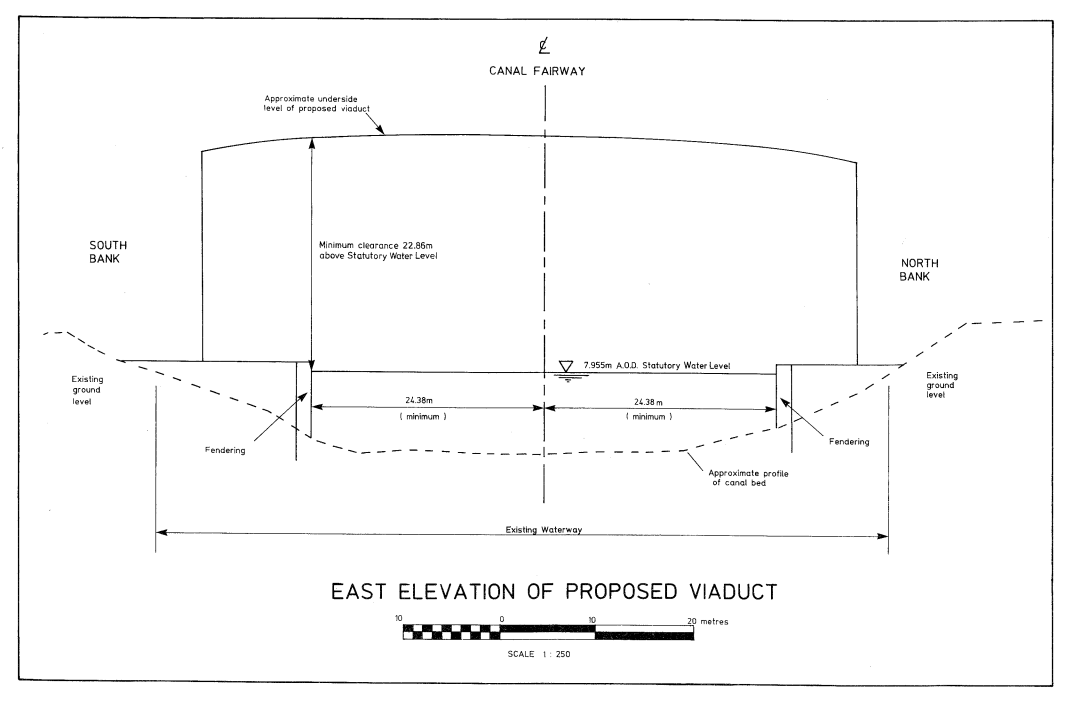
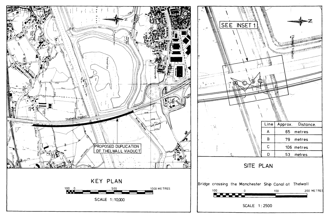
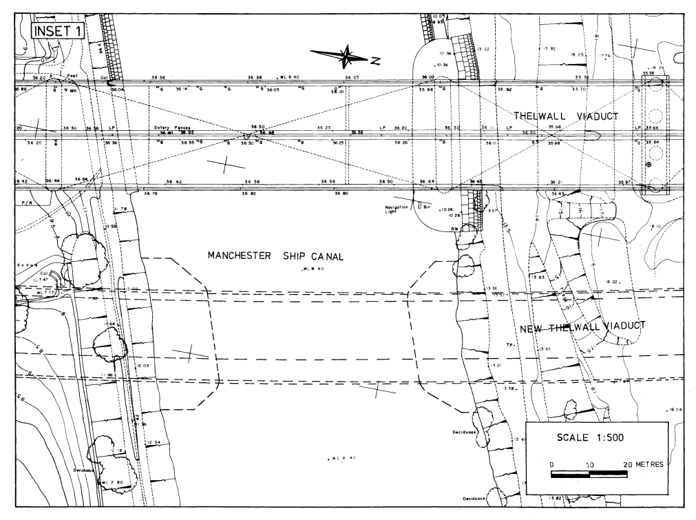
SCHEDULE 3 WITH KEY PLAN AND SITE PLANPLANS AND SPECIFICATIONS FOR THE VIADUCT CROSSING THE MANCHESTER SHIP CANAL AT THELWALL
Points of Commencement and Termination
From a point south of the centreline of the Manchester Ship Canal in the Borough of Warrington in the County of Cheshire 65 metres north east from the centre of the northern face of the Thelwall Viaduct pier on the southern bank of the canal and 79 metres south east from the centre of the southern face of the Thelwall Viaduct pier on the northern bank of the canal.
To a point north of the centreline of the Manchester Ship Canal 106 metres north east from the centre of the northern face of the Thelwall Viaduct pier on the southern bank of the canal and 53 metres east from the centre of the southern face of the Thelwall Viaduct pier on the northern bank of the canal.
Construction
Composite steel girder and reinforced concrete deck on reinforced concrete piers.
Headroom
22.86 metres minimum headroom above statutory water level above canal fairway tapering to 20.62 metres above statutory water level 5.64 metres from the edge of the fairway.
Diversion of the Canal
This would have the effect of diverting the southern bank of the waterway northwards by a maximum distance of 16 metres and the northern bank of the waterway southwards by a maximum distance of 14 metres. The existing waterway width of 79 metres would be reduced to a minimum width of 48.76 metres.
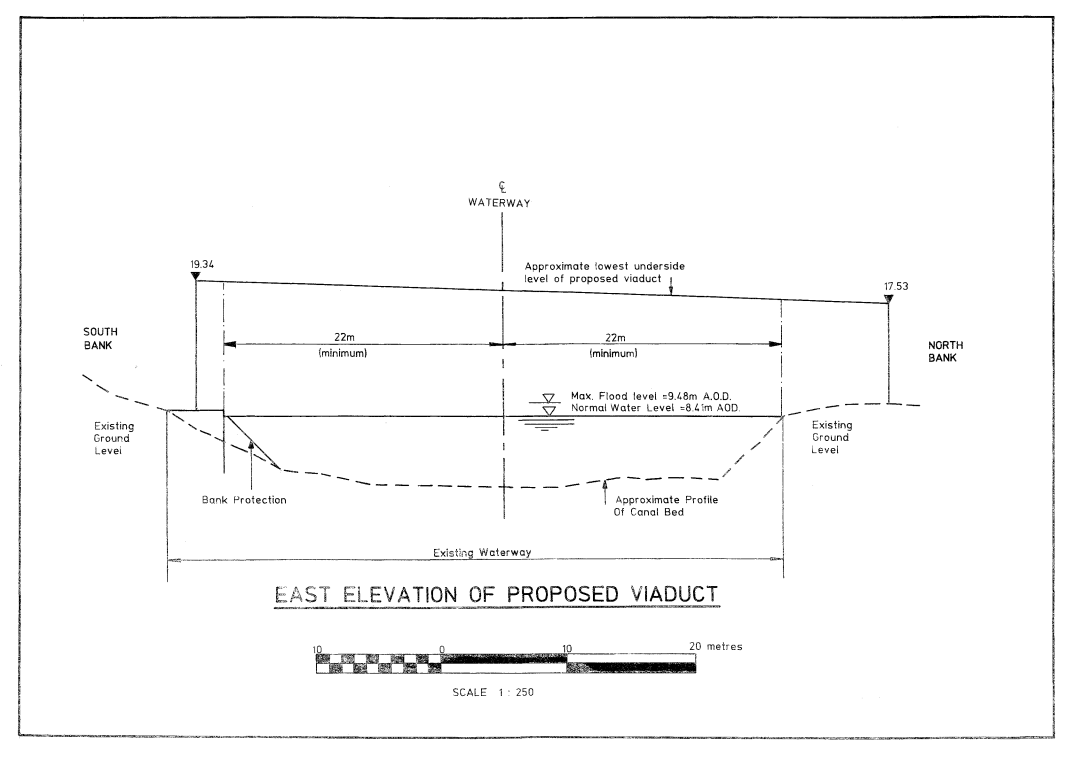
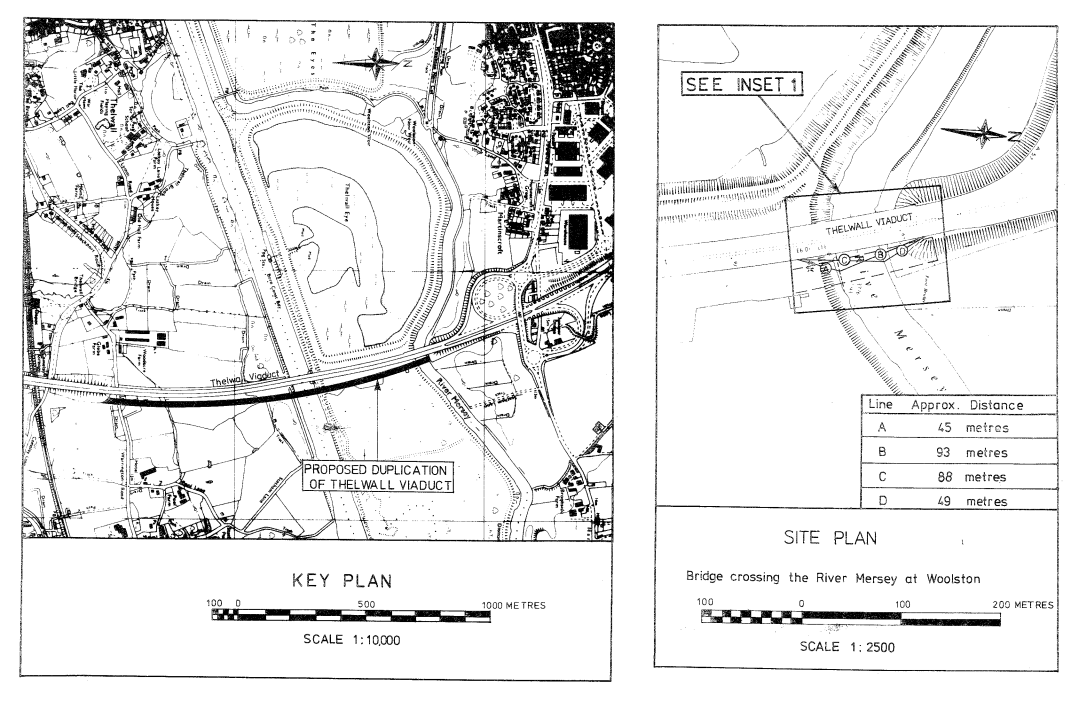
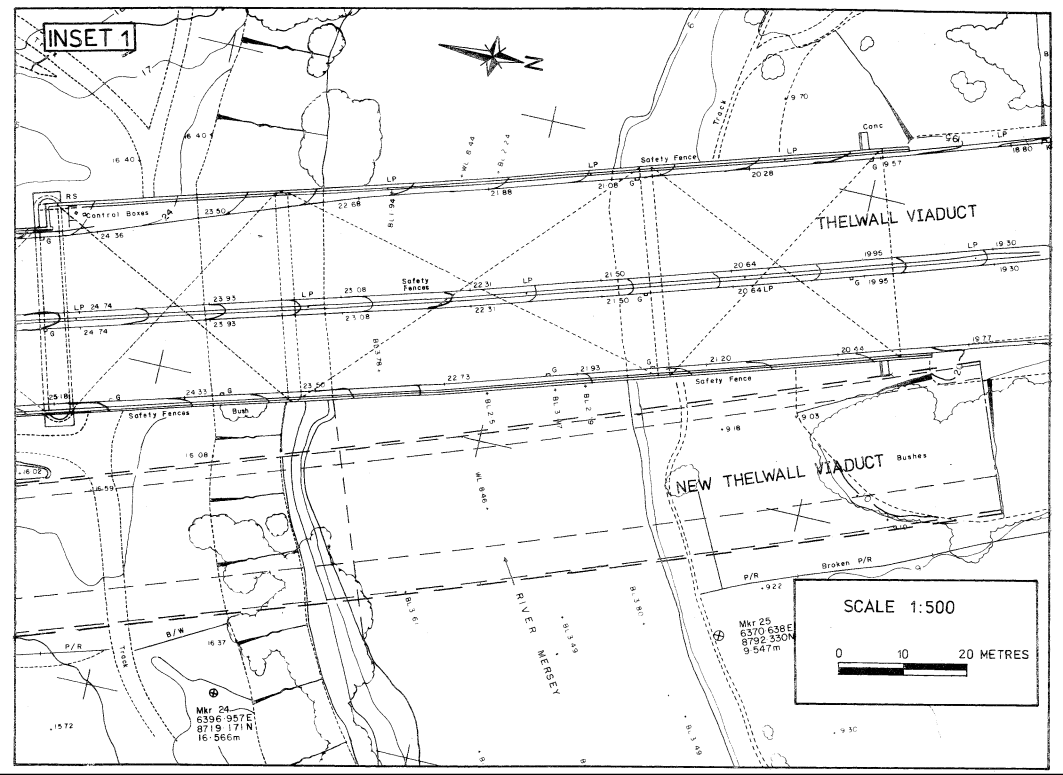
SCHEDULE 4 WITH KEY PLAN AND SITE PLANPLANS AND SPECIFICATIONS FOR THE VIADUCT CROSSING THE RIVER MERSEY AT WOOLSTON
Points of Commencement and Termination
From a point south of the centreline of the River Mersey in the Borough of Warrington in the County of Cheshire 45 metres north of the north east corner of the pilecap of Thelwall Viaduct Pier HH and 93 metres south east of the north east corner of the eastern wingwall of the northern abutment of Thelwall Viaduct.
To a point north of the centreline of the River Mersey 88 metres north of the north east corner of the pilecap of Thelwall Viaduct pier HH and 49 metres south east of the north east corner of the eastern wingwall of the northern abutment of Thelwall Viaduct.
Construction
Composite steel girder and reinforced concrete deck on reinforced concrete piers.
Headroom
Headroom to be not less than 9.12m above normal navigation level which is 8.41m above Ordnance Datum to be maintained for a distance of 22 metres each side of the centreline of the navigable waterway.
Waterway
As defined by the above limits at normal navigation level.
Diversion of the Waterway
This would have the effect of diverting the southern bank of the waterway northwards by a maximum distance of 6 metres. The existing waterway width of 50 metres would be reduced to a minimum width of 44 metres.
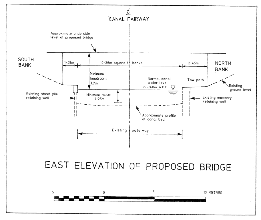
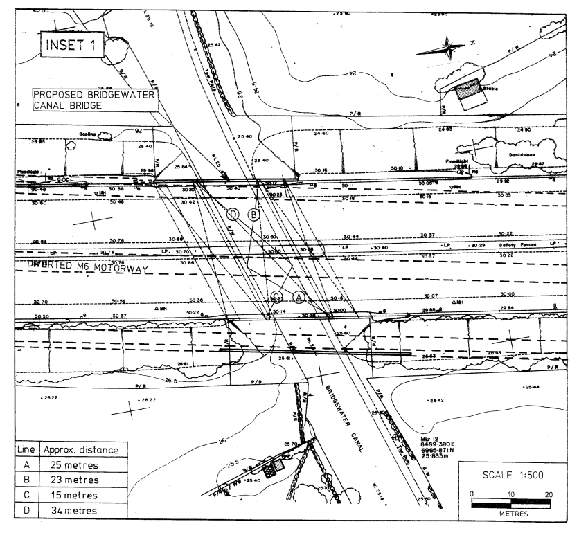
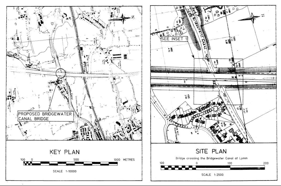
SCHEDULE 5 WITH KEY PLAN AND SITE PLANPLANS AND SPECIFICATIONS FOR THE BRIDGE CROSSING THE BRIDGEWATER CANAL AT LYMM
Points of Commencement and Termination
From a point south of the centreline of the Bridgewater Canal in the Borough of Warrington in the County of Cheshire 25 metres south west from the easternmost column of the northern pier of the Bridgewater Canal Bridge and 23 metres south east from the westernmost column of the northern pier of the Bridgewater Canal Bridge.
To a point north of the centreline of the Bridgewater Canal 15 metres north west from the easternmost column of the southern pier of the Bridgewater Canal Bridge and 34 metres north east from the westernmost column of the southern pier of the Bridgewater Canal Bridge.
Construction
Composite steel girder and reinforced concrete deck on reinforced concrete piers.
Headroom
3.7 metres minimum headroom above Normal Canal Water Level.