1989 No. 1390
The Black Country Development Corporation (Vesting of Land) (General) Order 1989
Approved by both Houses of Parliament
Made
Laid before Parliament
Coming into force
The Secretary of State for the Environment, being also the appropriate Minister (in the case of land vested in any statutory undertakers mentioned in the Schedule to this Order) for the purposes of section 141(3) of the Local Government, Planning and Land Act 19801, in exercise of the powers conferred on him by section 141(1) and (3) of that Act and of all other powers enabling him in that behalf, hereby makes the following Order:
Citation and commencement1
This Order may be cited as the Black Country Development Corporation (Vesting of Land) (General) Order 1989 and shall come into force on the day after the day on which it is approved by resolution of each House of Parliament.
Interpretation2
1
In this Order—
“the Corporation” means the Black Country Development Corporation;
“statutory undertakers” does not include any statutory undertakers in relation to whom the Secretary of State for the Environment is not the appropriate Minister;
“urban development areas” means the areas designated as urban development areas by the Black Country Development Corporation (Area and Constitution) Order 19872 and the Wolverhampton Urban Development Area Order 19883.
2
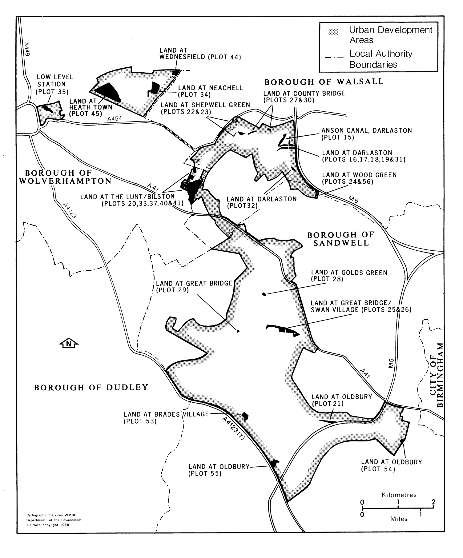
Any reference in this Order to a map followed immediately by a number is a reference to the map so numbered in the set of maps numbered 9 to 24, 26, 27 and 29 to 33 entitled “Maps referred to in the Black Country Development Corporation (Vesting of Land) (General) Order 1989”, of which prints, signed by an Under Secretary in the Department of the Environment, are deposited and available for inspection at the offices of the Secretary of State for the Environment, the British Waterways Board, the Severn-Trent Water Authority, the councils of the boroughs of Sandwell, Walsall and Wolverhampton, the West Midlands Residuary Body and the Corporation.
3
Any reference in this Order to a numbered plot is a reference to the plot so numbered and shown bounded externally with a black line and either stippled or edged internally with a stippled band on a numbered map.
Vesting of land3
The land described in the Schedule hereto and now vested in a body mentioned in the Schedule or in any other local authority or statutory undertakers or other public body or in a subsidiary of any of them, being land within the urban development areas, is hereby vested in the Corporation.
Easements and rights in or over land4
All existing easements and rights in or over other land within the urban development areas which are vested in an authority or body mentioned in article 3 above, and which are annexed or appurtenant to land vested by that article or any part thereof, are hereby vested in the Corporation.
THE SCHEDULELAND VESTED IN THE CORPORATION
PART 1LAND OF THE BRITISH WATERWAYS BOARD
Plot Number | |
|---|---|
15 | Approximately 2.029 hectares of land, at Darlaston, in the borough of Walsall, shown on map 9. |
16 | Approximately 0.450 hectares of land, adjacent to James Bridge, Darlaston, in the borough of Walsall, shown on map 9. |
17 | Approximately 0.169 hectares of land, adjacent to James Bridge, Darlaston, in the borough of Walsall, shown on map 9. |
18 | Approximately 0.720 hectares of land, adjacent to James Bridge, Darlaston, in the borough of Walsall, shown on map 9. |
19 | Approximately 0.230 hectares of land, adjacent to James Bridge, Darlaston, in the borough of Walsall, shown on map 9. |
20 | Approximately 0.698 hectares of land, at Bilston, in the borough of Walsall, shown on map 10. |
21 | Approximately 2.616 hectares of land, at Oldbury, in the borough of Sandwell, shown on map 11. |
PART 2LAND OF THE WEST MIDLANDS RESIDUARY BODY
22 | Approximately 0.131 hectares of land, at Shepwell Green, in the borough of Walsall, shown on map 12. |
23 | Approximately 1.595 hectares of land, at Shepwell Green, in the borough of Walsall, shown on map 13. |
24 | Approximately 0.090 hectares of land, adjacent to Wood Green Road, Wood Green, in the borough of Sandwell, shown on map 14. |
25 | Approximately 7.070 hectares of land, at Great Bridge, in the borough of Sandwell, shown on map 15. |
26 | Approximately 0.767 hectares of land, at Swan Village, in the borough of Sandwell, shown on map 15. |
27 | Approximately 0.012 hectares of land, at Bentley Road North, County Bridge, in the borough of Walsall, shown on map 16. |
28 | Approximately 0.799 hectares of land, at Golds Green, in the borough of Sandwell, shown on map 17. |
29 | Approximately 0.016 hectares of land, at Great Bridge, in the borough of Sandwell, shown on map 18. |
PART 3LAND OF THE SEVERN-TRENT WATER AUTHORITY
30 | Approximately 0.1690 hectares of land, at County Bridge, in the borough of Walsall, shown on map 19. |
31 | Approximately 0.237 hectares of land, at Darlaston, in the borough of Walsall, shown on map 20. |
32 | Approximately 0.050 hectares of land, at Darlaston, in the borough of Walsall, shown on map 21. |
33 | Approximately 13.697 hectares of land, at Bilston, in the borough of Wolverhampton, shown on map 22. |
34 | Approximately 6.683 hectares of land, at Watery Lane, Neachell, in the borough of shown on map 33. |
PART 4LAND OF THE COUNCIL OF THE BOROUGH OF WOLVERHAMPTON
35 | Approximately 2.638 hectares of land, at Low Level Station, in the borough of Wolverhampton, shown on map 23. |
37 | Approximately 1.254 hectares of land, at The Lunt, Bilston, in the borough of Wolverhampton, shown on map 24. |
40 | Approximately 0.505 hectares of land, at The Lunt, Bilston, in the borough of Wolverhampton, shown on map 24. |
41 | Approximately 0.730 hectares of land, at Murdoch Road, Bilston, in the borough of Wolverhampton, shown on map 24. |
44 | Approximately 2.226 hectares of land, at Wednesfield, in the borough of Wolverhampton, shown on map 26. |
45 | Approximately 25.963 hectares of land, at Heath Town, in the borough of Wolverhampton, shown on map 27. |
PARTS 5LAND OF THE COUNCIL OF THE BOROUGH OF SANDWELL
53 | Approximately 2.527 hectares of land, at Brades Village, in the borough of Sandwell, shown on map 29. |
54 | Approximately 0.775 hectares of land, at Brasshouse Lane, Oldbury, in the borough of Sandwell, shown on map 30. |
55 | Approximately 2.396 hectares of land, at Wolverhampton Road, Oldbury, in the borough of Sandwell, shown on map 31. |
56 | Approximately 0.093 hectares of land, adjacent to Wood Green Road, in the borough of Sandwell, shown on map 32. |
(This note is not part of the Order)
This Order vests in the Black Country Development Corporation certain land which is at present vested in the councils of the boroughs of Sandwell and Wolverhampton, the British Waterways Board, the Severn-Trent Water Authority, the West Midlands Residuary Body (or in another body mentioned in Section 141(1) of the Local Government, Planning and Land Act 1980), and related easements and similar rights.
The land is shown coloured black on the map forming part of this note. The land and rights are in the areas designated by the Black Country Development Corporation (Area and Constitution) Order 1987, which establishes the Black Country Development Corporation, and the Wolverhampton Urban Development Area Order 1988.
The Black Country Development Corporation exercises the functions of an urban development corporation for the Wolverhampton urban development area.