1989 No. 1389
The Black Country Development Corporation (Vesting of Land) (Borough of Walsall) Order 1989
Approved by both Houses of Parliament
Made
Laid before Parliament
Coming into force
The Secretary of State for the Environment, in exercise of the powers conferred on him by section 141(1) of the Local Government, Planning and Land Act 19801 and of all other powers enabling him in that behalf, hereby makes the following Order:
Citation and commencement1
This Order may be cited as the Black Country Development Corporation (Vesting of Land) (Borough of Walsall) Order 1989 and shall come into force on the day after the day on which it is approved by resolution of each House of Parliament.
Interpretation2
1
In this Order–
“the Corporation” means the Black Country Development Corporation;
“statutory undertakers” does not include any statutory undertakers in relation to whom the Secretary of State for the Environment is not the appropriate Minister2;
“urban development areas” means the areas designated as urban development areas by the Black Country Development Corporation (Area and Constitution) Order 19873 and the Wolverhampton Urban Development Area Order 19884.
2
Any reference in this Order to a map followed immediately by a number is a reference to the map so numbered in the set of maps numbered 1 to 8 entitled “Maps referred to in the Black Country Development Corporation (Vesting of Land) (Borough of Walsall) Order 1989”, of which prints, signed by an Under Secretary in the Department of the Environment, are deposited and available for inspection at the offices of the Secretary of State for the Environment, the councils of the boroughs of Walsall and Wolverhampton and the Corporation.
3
Any reference in this Order to a numbered plot is a reference to the plot so numbered and shown bounded externally with a black line and edged internally with a stippled band on a numbered map.
Vesting of land3
The land described in the Schedule hereto and now vested in the council of the borough of Walsall or in another local authority or statutory undertakers or other public body or in a subsidiary of any of them, being land within the urban development areas, is hereby vested in the Corporation.
Easements and rights in or over land4
All existing easements and rights in or over other land within the urban development areas which are vested in an authority or body mentioned in article 3 above, and which are annexed or appurtenant to land vested by that article or any part thereof, are hereby vested in the Corporation.
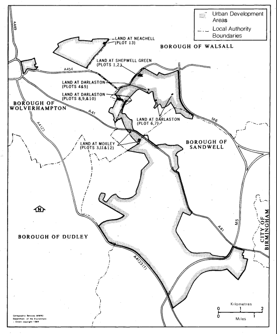
THE SCHEDULELAND VESTED IN THE CORPORATION
Plot Number | |
|---|---|
1 | Approximately 2.489 hectares of land, adjacent to The Crescent, Shepwell Green, in the borough of Walsall, shown on map 1. |
2 | Approximately 0.049 hectares of land, adjacent to The Crescent, Shepwell Green, in the borough of Walsall, shown on map 1. |
3 | Approximately 0.090 hectares of land, adjacent to Church Street, Moxley, in the borough of Walsall, shown on map 2. |
4 | Approximately 0.077 hectares of land, at Booth Street, Darlaston, in the borough of Walsall, shown on map 3. |
5 | Approximately 0.118 hectares of land, at The Green, Darlaston, in the borough of Walsall, shown on map 3. |
6 | Approximately 0.390 hectares of land, at Richards Street, Darlaston, in the borough of Walsall, shown on map 4. |
7 | Approximately 0.104 hectares of land, adjacent to Darlaston Road, Darlaston, in the borough of Walsall, shown on map 5. |
8 | Approximately 1.417 hectares of land, adjacent to Darlaston Lane, Darlaston, in the borough of Walsall, shown on map 6. |
9 | Approximately 0.335 hectares of land, adjacent to Darlaston Lane, Darlaston, in the borough of Walsall, shown on map 6. |
10 | Approximately 1.770 hectares of land, adjacent to Darlaston Lane, Darlaston, in the borough of Walsall, shown on map 6. |
11 | Approximately 0.628 hectares of land, at Western Way, Moxley, in the borough of Walsall, shown on map 7. |
12 | Approximately 0.248 hectares of land, at Southern Way, Moxley, in the borough of Walsall, shown on map 7. |
13 | Approximately 1.603 hectares of land, at Neachell, in the borough of Wolverhampton, shown on map 8. |
(This note is not part of the Order)
This Order vests in the Black Country Development Corporation certain land which is at present vested in the council of the borough of Walsall (or in another body mentioned in section 141(1) of the Local Government, Planning and Land Act 1980), and related easements and similar rights. The land is shown coloured black on the map forming part of this note.
The land and rights are in the areas designated by the Black Country Development Corporation (Area and Constitution) Order 1987, which establishes the Black Country Development Corporation, and the Wolverhampton Urban Development Area Order 1988. The Black Country Development Corporation exercises the functions of an urban development corporation for the Wolverhampton urban development area.