1989 No. 1305
The Merseyside Development Corporation (Vesting of Land) (General) Order 1989
Approved by both Houses of Parliament
Made
Laid before Parliament
Coming into force
The Secretary of State for the Environment, in exercise of the powers conferred on him by section 141(1) of the Local Government, Planning and Land Act 19801, and of all other powers enabling him in that behalf, hereby makes the following Order:
Citation and commencement1
This Order may be cited as the Merseyside Development Corporation (Vesting of Land) (General) Order 1989 and shall come into force on the day after the day on which it is approved by resolution of each House of Parliament.
Interpretation2
1
In this Order–
“the Corporation” means the Merseyside Development Corporation;
“statutory undertakers” does not include any statutory undertakers in relation to whom the Secretary of State for the Environment is not the appropriate Minister2;
“urban development areas” means the areas designated as urban development areas by the Merseyside Development Corporation (Area and Constitution) Order 19803 and the Liverpool and Wirral Urban Development Area Order 19884.
2
Any reference in this Order to a map followed immediately by a number is a reference to the map so numbered in the set of maps numbered 1 to 9 entitled “Maps referred to in the Merseyside Development Corporation (Vesting of Land) (General) Order 1989”, of which prints, signed by an Under Secretary in the Department of the Environment, are deposited and available for inspection at the offices of the Secretary of State for the Environment, the councils of the city of Liverpool and the borough of Wirral, the Merseyside Residuary Body and the Corporation.
3
Any reference in this Order to a numbered plot is a reference to the plot so numbered and shown bounded externally with a black line and either stippled or edged internally with a stippled band on a numbered map.
Vesting of land3
The land described in the Schedule hereto and now vested in a body mentioned in the Schedule or in any other local authority or statutory undertakers or other public body or in a subsidiary of any of them, being land within the urban development areas, is hereby vested in the Corporation.
Easements and rights in or over land4
All existing easements and rights in or over other land within the urban development areas which are vested in an authority or body mentioned in article 3 above, and which are annexed or appurtenant to land vested by that article or any part thereof, are hereby vested in the Corporation.
THE SCHEDULELAND VESTED IN THE CORPORATION
PART 1LAND OF THE COUNCIL OF THE CITY OF LIVERPOOL
Plot Number | |
|---|---|
1 | Approximately 2.61 hectares of land, at Bankhall Street, Bankhall, in the city of Liverpool, shown on map 1. |
2 | Approximately 0.85 hectares of land, at Athol Street, Vauxhall, in the city of Liverpool, shown on map 2. |
3 | Approximately 0.10 hectares of land, at Paisley Street, Vauxhall, in the city of Liverpool, shown on map 3. |
4 | Approximately 1.50 hectares of land, |
5 | Approximately 0.34 hectares of land, each at Vauxhall Road, Vauxhall, in the city of Liverpool, shown on map 3. |
6 | Approximately 0.48 hectares of land, |
7 | Approximately 0.15 hectares of land, each at Gascoyne Street, Vauxhall, in the city of Liverpool, shown on map 3. |
8 | Approximately 0.13 hectares of land, at Oriel Street, Vauxhall, in the city of Liverpool, shown on map 3. |
10 | Approximately 0.03 hectares of land, at Wellington Street, Vauxhall, in the city of Liverpool, shown on map 3. |
11 | Approximately 0.22 hectares of land, |
12 | Approximately 0.35 hectares of land, each at Carruthers Street, Vauxhall, in the city of Liverpool, shown on map 3. |
13 | Approximately 0.20 hectares of land, at Carlton Street, Vauxhall, in the city of Liverpool shown on map 3. |
14 | Approximately 0.25 hectares of land, at Regent Street, Vauxhall, in the city of Liverpool, shown on map 3. |
15 | Approximately 0.66 hectares of land, at Saltney Street, Vauxhall, in the city of Liverpool, shown on map 3. |
16 | Approximately 0.10 hectares of land, at Strand Street, Cornwallis, in the city of Liverpool, shown on map 4. |
17 | Approximately 0.28 hectares of land, |
18 | Approximately 0.08 hectares of land, |
30 | Approximately 0.24 hectares of land, |
31 | Approximately 0.09 hectares of land, each at Park Lane, Cornwallis, in the city of Liverpool, shown on map 5. |
19 | Approximately 0.03 hectares of land, |
20 | Approximately 0.30 hectares of land, |
21 | Approximately 0.09 hectares of land, |
90 | Approximately 0.04 hectares of land, each at Liver Street, Cornwallis, in the city of Liverpool, shown on map 5. |
89 | Approximately 0.06 hectares of land, at Pownall Street, Cornwallis, in the City of Liverpool, shown on map 5. |
22 | Approximately 0.08 hectares of land, |
23 | Approximately 0.10 hectares of land, |
24 | Approximately 0.05 hectares of land, |
25 | Approximately 0.25 hectares of land, |
91 | Approximately 0.18 hectares of land, |
92 | Approximately 0.01 hectares of land, each at Wapping, Cornwallis, in the city of Liverpool, shown on map 5. |
26 | Approximately 0.18 hectares of land, |
27 | Approximately 0.08 hectares of land, |
93 | Approximately 0.02 hectares of land, each at Hurst Street, Cornwallis, in the city of Liverpool, shown on map 5. |
28 | Approximately 0.32 hectares of land, |
94 | Approximately 0.03 hectares of land, |
95 | Approximately 0.06 hectares of land, each at Grayson Street, Cornwallis, in the city of Liverpool, shown on map 5. |
29 | Approximately 0.28 hectares of land, at Tabley Street, Cornwallis, in the city of Liverpool, shown on map 5. |
32 | Approximately 0.02 hectares of land, |
33 | Approximately 0.05 hectares of land, |
96 | Approximately 0.01 hectares of land, |
34 | Approximately 0.12 hectares of land, each at Shaws Alley, Cornwallis, in the city of Liverpool, shown on map 5. |
35 | Approximately 0.02 hectares of land, at Carpenters Row, Cornwallis, in the city of Liverpool, shown on map 5. |
36 | Approximately 0.04 hectares of land, |
97 | Approximately 0.06 hectares of land, each at Blundell Street, Cornwallis, in the city of Liverpool, shown on map 5. |
37 | Approximately 0.56 hectares of land, |
38 | Approximately 0.33 hectares of land, |
39 | Approximately 0.07 hectares of land, |
40 | Approximately 0.12 hectares of land, |
98 | Approximately 0.03 hectares of land, each at Bridgewater Street, Cornwallis, in the city of Liverpool, shown on map 5. |
42 | Approximately 0.98 hectares of land, at Jordan Street, Cornwallis, in the city of Liverpool, shown on map 5. |
71 | Approximately 0.06 hectares of land, at Nicholas Street, Vauxhall, in the city of Liverpool, shown on map 3. |
PART 2LAND OF THE COUNCIL OF THE BOROUGH OF WIRRAL
43 | Approximately 0.15 hectares of land, |
44 | Approximately 1.88 hectares of land, |
45 | Approximately 0.51 hectares of land, each at Marine Promenade, New Brighton, in the borough of Wirral, shown on map 6. |
46 | Approximately 0.10 hectares of land, |
47 | Approximately 0.08 hectares of land, |
48 | Approximately 0.05 hectares of land, each at Victoria Road, New Brighton, in the borough of Wirral, shown on map 6. |
49 | Approximately 0.14 hectares of land, |
50 | Approximately 0.22 hectares of land, |
51 | Approximately 0.39 hectares of land, each at Cleveland Street, Birkenhead, in the borough of Wirral, shown on map 7. |
52 | Approximately 0.19 hectares of land, at Cathcart Street, Birkenhead, in the borough of Wirral, shown on map 7. |
53 | Approximately 0.24 hectares of land, at Price Street, Birkenhead, in the borough of Wirral, shown on map 7. |
54 | Approximately 0.78 hectares of land, at Pool Street, Birkenhead, in the borough of Wirral, shown on map 7. |
55 | Approximately 0.38 hectares of land, at Bridge Street, Birkenhead, in the borough of Wirral, shown on map 7. |
56 | Approximately 0.37 hectares of land, at Argyle Street, Birkenhead, in the borough of Wirral, shown on map 7. |
58 | Approximately 0.30 hectares of land, at Woodside, Birkenhead, in the borough of Wirral, shown on map 7. |
59 | Approximately 0.21 hectares of land, at Hamilton Street, Birkenhead, in the borough of Wirral, shown on map 8. |
60 | Approximately 0.41 hectares of land, at Herbert Place, Birkenhead, in the borough of Wirral, shown on map 8. |
61 | Approximately 0.28 hectares of land, at Pilgrim Street, Birkenhead, in the borough of Wirral, shown on map 8. |
62 | Approximately 0.12 hectares of land, at Duncan Street, Birkenhead, in the borough of Wirral, shown on map 8. |
63 | Approximately 0.85 hectares of land, at Abbey Street, Birkenhead, in the borough of Wirral, shown on map 9. |
64 | Approximately 0.27 hectares of land, at Abbey Close, Birkenhead, in the borough of Wirral, shown on map 9. |
65 | Approximately 0.44 hectares of land, at New Chester Road, Birkenhead, in the borough of Wirral, shown on map 9. |
66 | Approximately 0.95 hectares of land, at Mason Street, Birkenhead, in the borough of Wirral, shown on map 9. |
67 | Approximately 2.04 hectares of land, |
68 | Approximately 2.38 hectares of land, |
69 | Approximately 5.50 hectares of land, each at Kings Parade, New Brighton, in the borough of Wirral, shown on map 6. |
99 | Approximately 0.03 hectares of land, at Rendel Street, Birkenhead, in the borough of Wirral, shown on map 7. |
PART 3LAND OF THE MERSEYSIDE RESIDUARY BODY
70 | Approximately 0.06 hectares of land, at Wellington Street, Vauxhall, in the city of Liverpool, shown on map 3. |
71 | Approximately 0.06 hectares of land, at Nicholas Street, Vauxhall, in the city of Liverpool, shown on map 3. |
72 | Approximately 1.12 hectares of land, at Naylor Street, Vauxhall, in the city of Liverpool, shown on map 3. |
73 | Approximately 0.05 hectares of land, at Maghull Street, Cornwallis, in the city of Liverpool, shown on map 5. |
19 | Approximately 0.03 hectares of land, |
90 | Approximately 0.04 hectares of land, each at Liver Street, Cornwallis, in the city of Liverpool, shown on map 5. |
23 | Approximately 0.10 hectares of land, |
24 | Approximately 0.05 hectares of land, |
91 | Approximately 0.18 hectares of land, |
92 | Approximately 0.01 hectares of land, each at Wapping, Cornwallis, in the city of Liverpool, shown on map 5. |
93 | Approximately 0.02 hectares of land, |
74 | Approximately 0.20 hectares of land, each at Hurst Street, Cornwallis, in the city of Liverpool, shown on map 5. |
96 | Approximately 0.01 hectares of land, at Shaws Alley, Cornwallis, in the city of Liverpool, shown on map 5. |
35 | Approximately 0.02 hectares of land, at Carpenters Row, Cornwallis, in the city of Liverpool, shown on map 5. |
75 | Approximately 0.20 hectares of land, |
89 | Approximately 0.06 hectares of land, each at Pownall Street, Cornwallis, in the city of Liverpool, shown on map 5. |
94 | Approximately 0.03 hectares of land, |
95 | Approximately 0.10 hectares of land, each at Grayson Street, Cornwallis, in the city of Liverpool, shown on map 5. |
97 | Approximately 0.06 hectares of land, at Blundell Street, Cornwallis, in the city of Liverpool, shown on map 5. |
76 | Approximately 0.04 hectares of land, |
39 | Approximately 0.07 hectares of land, |
77 | Approximately 0.02 hectares of land, each at Bridgewater Street, Cornwallis, in the city of Liverpool, shown on map 5. |
42 | Approximately 0.98 hectares of land, at Jordan Street, Cornwallis, in the city of Liverpool, shown on map 5. |
78 | Approximately 0.02 hectares of land, at Chaloner Street, Cornwallis, in the city of Liverpool, shown on map 5. |
79 | Approximately 0.17 hectares of land, at Parliament Street, Cornwallis, in the city of Liverpool, shown on map 5. |
80 | Approximately 0.55 hectares of land, at Rendel Street, Birkenhead, in the Borough of Wirral, shown on map 7. |
81 | Approximately 0.30 hectares of land, at Marcus Street, Birkenhead, in the borough of Wirral, shown on map 7. |
82 | Approximately 0.20 hectares of land, at Abbey Street, Birkenhead, in the borough of Wirral, shown on map 9. |
83 | Approximately 3.40 hectares of land, at New Chester Road, Birkenhead, in the borough of Wirral, shown on map 9. |
98 | Approximately 0.01 hectares of land, at Kitchen Street, Cornwallis, in the city of Liverpool, shown on map 5. |
99 | Approximately 0.03 hectares of land, at Freeman Street, Birkenhead, in the borough of Wirral, shown on map 7. |
(This note is not part of the Order)
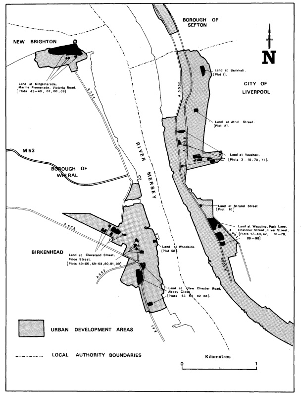
This Order vests in the Merseyside Development Corporation certain land which is at present vested in the councils of the city of Liverpool and the borough of Wirral, the Merseyside Residuary Body (or in another body mentioned in section 141(1) of the Local Government, Planning and Land Act 1980), and related easements and similar rights. The land is shown coloured black on the map forming part of this note.
In some instances where the present ownership of the land to be vested is a matter of dispute between two or more of the bodies mentioned in the Schedule to this Order or where the bodies own different interests in the land, the description of the land is, to that extent, duplicated in the Schedule.
The land and rights are in the areas designated by the Merseyside Development Corporation (Area and Constitution) Order 1980 (which establishes the Merseyside Development Corporation) and the Liverpool and Wirral Urban Development Area Order 1988. The Merseyside Development Corporation exercises the functions of an urban development corporation for the Liverpool and Wirral urban development area.