- Latest available (Revised)
- Original (As made)
The Clydebank and City of Glasgow Districts (Yoker) Boundaries Amendment Order 1988
You are here:

What Version
More Resources
Status:
This is the original version (as it was originally made). This item of legislation is currently only available in its original format.
Articles 2, 4 and 5
SCHEDULE
PART I
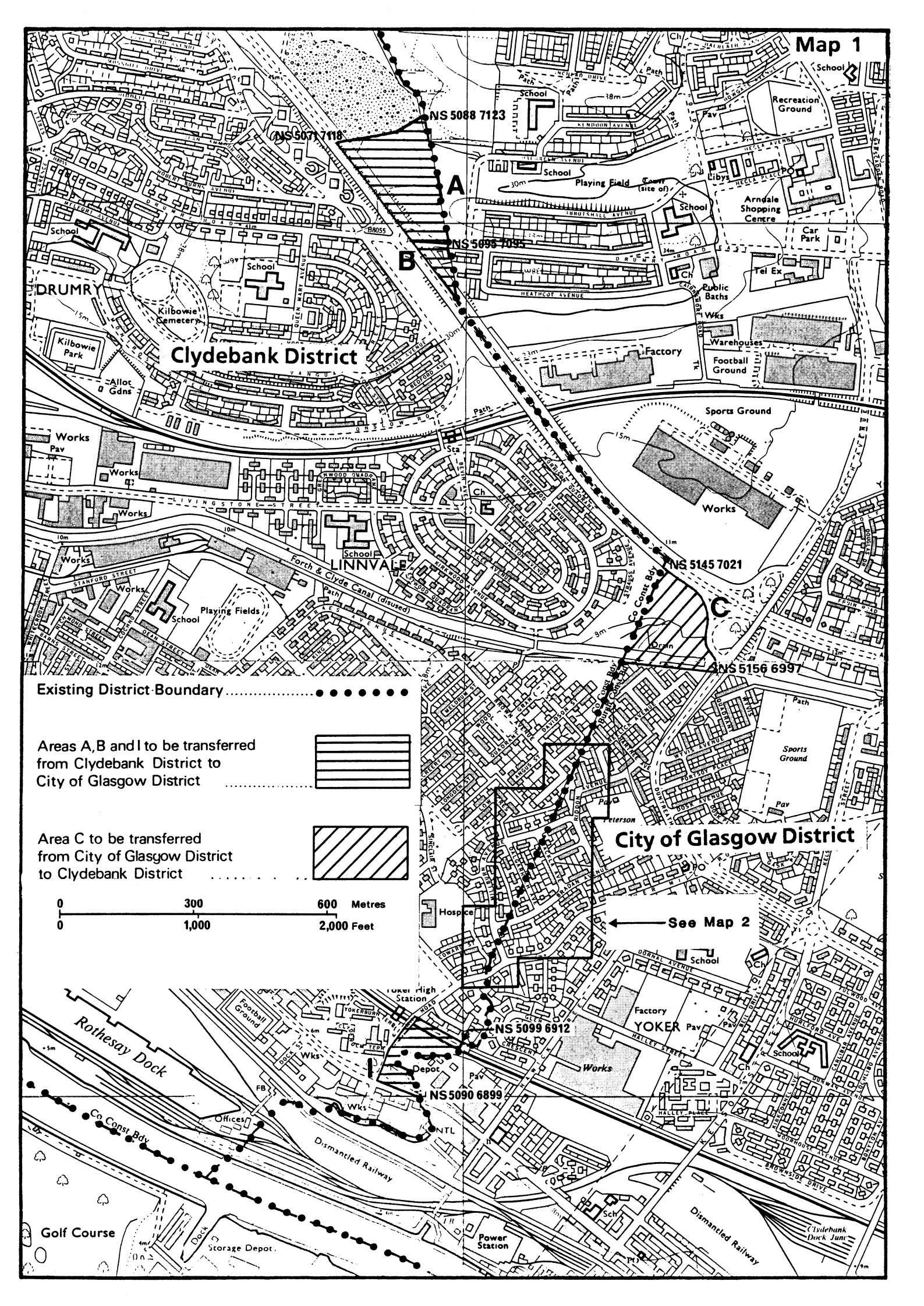
Area A
The area bounded by a line commencing on the district boundary at a point on the Cleddons Burn due northeastwards of a point grid reference NS 5088 7123 on the southeastern boundary of the Sports Ground on the northeastern side of the Great Western Road, then southwestwards to that point and along that Sports Ground boundary, then southwestwards to a point on the centre line of the Great Western Road grid reference NS 5071 7118, thereafter southeastwards along the centre line of Great Western Road to the centre of the roundabout at its intersection with Drumry Road, then eastwards along the centre line of Drumry Road to rejoin the district boundary, then northwestwards along that district boundary to the point of commencement.
Area B
The area bounded by a line commencing on the district boundary at a point on the centre line of Drumry Road grid reference NS 5095 7095, westwards along the centre line of that road to the centre of the roundabout at its intersection with Great Western Road, then southeastwards along the centre line of that road to rejoin the district boundary, thennorthwestwards along that district boundary to the point of commencement.
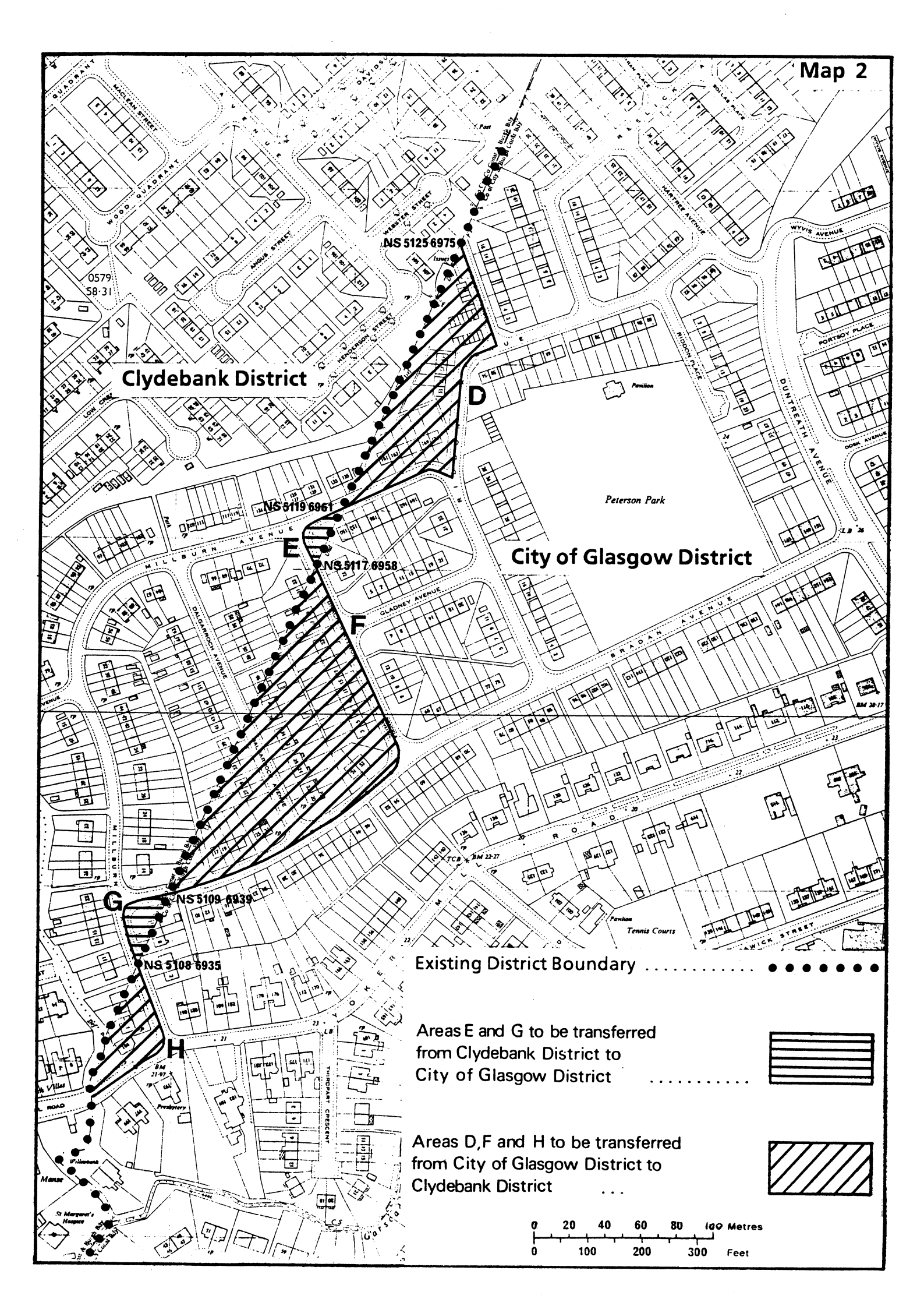
Area E
The area bounded by a line commencing on the district boundary at a point on the centre line of Millburn Avenue grid reference NS 5119 6961, southwestwards along the centre line of Millburn Avenue to its junction with Brackla Avenue, then southeastwards along the centre line of Brackla Avenue to rejoin the district boundary at a point grid reference NS 5117 6958, then northeastwards along that district boundary to the point of commencement.
Area G
The area bounded by a line commencing on the district boundary at a point on the centre line of Bradan Avenue grid reference NS 5109 6939, southwestwards along the centre line of Bradan Avenue to its junction with Millburn Avenue, then southeastwards along the centre line of Millburn Avenue to rejoin the district boundary at a point grid reference NS 5108 6935, then northeastwards along that district boundary to the point of commencement.
Area I
The area bounded by a line commencing at a point on the district boundary at grid reference NS 5099 6912, then northwestwards to and along the rear curtilages of Nos 8-1 Millbrae Crescent to the centre line of Mill Road, then southwestwards along the centre line of Mill Road to the centre line of Glasgow Road, Clydebank, then southeastwards along the centre line of that road to the district boundary at a point grid reference NS 5090 6899, then northwestwards and thereafter northeastwards along that district boundary to the point of commencement.
PART II
Area C
The area bounded by a line commencing on the district boundary at a point on the southwest side of Great Western Road grid reference NS 5145 7021, southeastwards along the south side of that road, then southeastwards along the southwest side of the slip road from Duntreath Avenue to a point grid reference NS 5156 6997, then westwards along the south side of the tow path at the Forth and Clyde Canal to the district boundary, then northeastwards along that district boundary to the point of commencement.
Area D
The area bounded by a line commencing on the district boundary at a point grid reference NS 5125 6975, southeastwards along the centre line of Ladhope Place to Riddon Avenue, then southwestwards along the centre line of Riddon Avenue to Millburn Avenue, then generally southwestwards along the centre line of Millburn Avenue to rejoin the district boundary at a point grid reference NS 5119 6961, then northeastwards along that district boundary to the point of commencement.
Area F
The area bounded by a line commencing on the district boundary at a point on Brackla Avenue grid reference NS 5117 6958, southeastwards along the centre line of Brackla Avenue to its junction with Bradan Avenue, then southwestwards along the centre line of Bradan Avenue to rejoin the district boundary at a point grid reference NS 5109 6939, then northeastwards along that district boundary to the point of commencement.
Area H
The area bounded by a line commencing on the district boundary at a point on Millburn Avenue grid reference NS 5108 6935, southeastwards along the centre line of Millburn Avenue to its junction with Yoker Mill Road, then southwestwards along the centre line of Yoker Mill Road to rejoin the district boundary, then northeastwards along that district boundary to the point of commencement.
Options/Help
Print Options
PrintThe Whole Instrument
PrintThis Schedule only

Legislation is available in different versions:
Latest Available (revised):The latest available updated version of the legislation incorporating changes made by subsequent legislation and applied by our editorial team. Changes we have not yet applied to the text, can be found in the ‘Changes to Legislation’ area.
Original (As Enacted or Made): The original version of the legislation as it stood when it was enacted or made. No changes have been applied to the text.
Opening Options
Different options to open legislation in order to view more content on screen at once
More Resources
Access essential accompanying documents and information for this legislation item from this tab. Dependent on the legislation item being viewed this may include:
- the original print PDF of the as enacted version that was used for the print copy
- lists of changes made by and/or affecting this legislation item
- confers power and blanket amendment details
- all formats of all associated documents
- correction slips
- links to related legislation and further information resources
More Resources
Use this menu to access essential accompanying documents and information for this legislation item. Dependent on the legislation item being viewed this may include:
- the original print PDF of the as made version that was used for the print copy
- correction slips
Click 'View More' or select 'More Resources' tab for additional information including:
- lists of changes made by and/or affecting this legislation item
- confers power and blanket amendment details
- all formats of all associated documents
- links to related legislation and further information resources
 All content is available under the Open Government Licence v3.0 except where otherwise stated. This site additionally contains content derived from EUR-Lex, reused under the terms of the Commission Decision 2011/833/EU on the reuse of documents from the EU institutions. For more information see the EUR-Lex public statement on re-use.