- Latest available (Revised)
- Original (As made)
The Sea Fish (Prohibited Methods of Fishing) (Firth of Clyde) Order 2019
You are here:
- Scottish Statutory Instruments
- 2019 No. 419
- Whole Instrument
- Previous
- Next

What Version
Opening Options
More Resources
Status:
This is the original version (as it was originally made).
Scottish Statutory Instruments
2019 No. 419
Sea Fisheries
Conservation Of Sea Fish
The Sea Fish (Prohibited Methods of Fishing) (Firth of Clyde) Order 2019
Made
10th December 2019
Laid before the Scottish Parliament
12th December 2019
Coming into force
14th February 2020
The Scottish Ministers make the following Order in exercise of the powers conferred by sections 5(1)(a) and (2), 15(3), 20(1), 22(2) and 22A of the Sea Fish (Conservation) Act 1967(1) and all other powers enabling them to do so.
Citation, commencement, cessation and effect
1.—(1) This Order may be cited as the Sea Fish (Prohibited Methods of Fishing) (Firth of Clyde) Order 2019 and comes into force on 14 February 2020.
(2) This Order remains in force until the end of 30 April 2021.
(3) The prohibition in article 3(1) has effect during the following periods—
(a)from 14 February 2020 until the end of 30 April 2020, and
(b)from 14 February 2021 until the end of 30 April 2021.
Interpretation
2.—(1) In this Order—
“British fishing boat” means a fishing boat which either is registered in the United Kingdom under Part II of the Merchant Shipping Act 1995(2) or is owned wholly by persons qualified to own British ships for the purposes of that Part of that Act,
“creel” means a basket, small cage, pot, receptacle or container with one or more openings or entrances, which may be baited and is placed on the seabed for the purpose of catching sea fish,
“ICES statistical rectangle” followed by numerals with a letter is a reference to whichever of the statistical sub-areas and divisions of the International Council for the Exploration of the Sea(3) is identified therein by those numerals and that letter,
“scallop dredge” means an appliance with a rigid framed mouth which is towed through the water and is manufactured, adapted, used or intended for use for the purpose of fishing for king scallops of the species Pecten maximus, and
“trawl” means a demersal trawl, seine net or similar towed net.
(2) For the purposes of this Order, a trawl is deemed to have been used for the purpose of fishing for Norway lobsters (of the species Nephrops norvegicus) if the catch retained on board a fishing boat is at least 30% by weight of Norway lobsters.
Prohibited methods of fishing
3.—(1) Fishing for sea fish by any method, by any British fishing boat, is prohibited in the area comprising that part of the Scottish zone contained within—
(a)that part of ICES statistical rectangle 39E4 which lies to the east of the peninsula of Kintyre and to the north of a straight line between 55°18′18″ north latitude, 05°38′50″ west longitude, and 55°00′30″ north latitude, 05°09′24″ west longitude, and
(b)that part of ICES statistical rectangle 39E4 which lies north of a straight line between 55°17′57″ north latitude, 05°47′54″ west longitude and 55°00′00″ north latitude, 05°21′00″ west longitude and to the south of a straight line between 55°18′18″ north latitude, 05°38′50″ west longitude and 55°00′30″ north latitude, 05°09′24″ west longitude(4).
(2) Subject to paragraph (4), the prohibition in paragraph (1)(a) does not apply to any British fishing boat that fishes with only—
(a)a scallop dredge,
(b)a creel, or
(c)a trawl used for fishing for Norway lobsters.
(3) The prohibition in paragraph (1)(b) does not apply to any British fishing boat that fishes with only—
(a)a scallop dredge, or
(b)a creel.
(4) Paragraph (2) is not to be read as allowing any fishing for sea fish in any part of the area described in paragraph (1)(a) which is otherwise prohibited by the South Arran Marine Conservation Order 2015(5).
Revocation
4. The Sea Fish (Prohibited Methods of Fishing) (Firth of Clyde) Order 2017(6) is revoked.
FERGUS EWING
A member of the Scottish Government
St Andrew’s House,
Edinburgh
10th December 2019
EXPLANATORY NOTE
(This note is not part of the Order)
This Order prohibits, subject to certain exceptions, all methods of fishing within specified areas of the Firth of Clyde from 14 February to 30 April, during both 2020 and 2021 (articles 1(3) and 3(1)). The Order is made in accordance with Article 19 of Regulation (EU) No 1380/2013 of the European Parliament and of the Council of 11 December 2013 on the Common Fisheries Policy and it remains in force until the end of 30 April 2021 (article 1(2)).
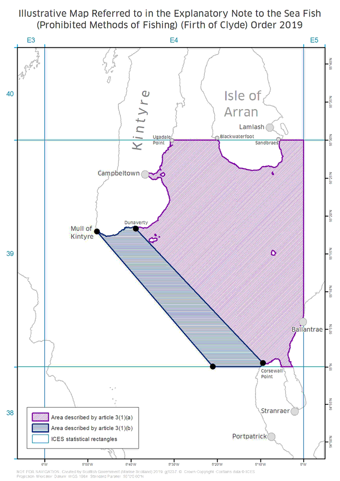
The areas closed to fishing under this Order are shown on the illustrative map which accompanies the Note.
The area diagonally hatched on the illustrative map is defined in article 3(1)(a).
The area horizontally hatched on the illustrative map is defined in article 3(1)(b).
The Order applies only to British fishing boats (article 3(1)). The prohibition does not apply to British fishing boats that fish within the closed areas exclusively with scallop dredges, creels or (in relation to the area diagonally hatched on the illustrative map) trawls used for fishing Norway lobsters (article 3(2) and (3)). However, the South Arran Marine Conservation Order 2015 imposes separate restrictions on fishing activities within part of the area described in article 3(1)(a). Article 3(4) provides that article 3(2) is not to be read as allowing fishing for sea fish within part of the area described in article 3(1)(a), where this is otherwise prohibited under that Order.
It is an offence under section 5(1) of the Sea Fish (Conservation) Act 1967 to use a fishing boat in contravention of a prohibition imposed by this Order. The penalties are fixed by section 11 of that Act. On summary conviction, the penalty is a fine not exceeding £50,000. On conviction on indictment, the penalty is an unlimited fine. In either case, the court may also order forfeiture of any fish in respect of which the offence was committed and of any net or other fishing gear used in committing the offence. On summary conviction, if the court does not order the forfeiture of fish, it may impose an additional fine not exceeding the value of the fish.
The Order revokes the Sea Fish (Prohibited Methods of Fishing) (Firth of Clyde) Order 2017 (article 4).
A Business and Regulatory Impact Assessment (“BRIA”) has been prepared in relation to this Order and placed in the Scottish Parliament Information Centre. Copies of the BRIA are available from Marine Scotland, Victoria Quay, Leith, Edinburgh EH6 6QQ and on line at www.legislation.gov.uk.
(1)
1967 c.84 (“the 1967 Act”). Section 5(1) of the 1967 Act was substituted by section 198(2) of the Marine and Coastal Access Act 2009 (c.23) (“the 2009 Act”), which extends to Scotland by virtue of section 158(1) of the Marine (Scotland) Act 2010 (asp 5) (“the 2010 Act”). Section 5(2) of the 1967 Act was amended by paragraph 3 of schedule 15 of the 2009 Act, which extends to Scotland by virtue of section 158(1) of the 2010 Act. Section 15(3) of the 1967 Act was substituted by section 22(5) and paragraph 38(3) of schedule 1 of the Sea Fisheries Act 1968 (c.77) and amended by paragraph 16(1) of schedule 2 of the Fishery Limits Act 1976 (c.86) and S.I. 1999/1820. Sections 5, 15(3), 20 and 22(2) of the 1967 Act are modified in relation to Scotland by section 22A(2), (6), (10), (11) and (12) of that Act. Section 22A of the 1967 Act was inserted by S.I. 1999/1820 and section 22A(6) of the 1967 Act was substituted by section 159(4) of the 2010 Act. Section 22(2) of the 1967 Act, which contains a definition of “the Ministers” for the purposes of section 15(3) of that Act, was relevantly amended by sections 19(2)(d) and 45 of the Fisheries Act 1981 (c.29). The definition of “the Ministers” was modified in relation to Scotland by section 22A(12)(b) of the 1967 Act.
(2)
(3)
Cmnd. 2586.
(4)
These are co-ordinates of latitude and longitude according to the World Geodetic System 1984 (“WGS 84”). WGS 84 is defined at paragraph 2.1 of the United States National Imagery and Mapping Agency Technical Report TR8350.2, third edition, amendment 1 of 3rd January 2000 entitled “Department of Defense World Geodetic System 1984” (http://earth-info.nga.mil/GandG/publications/tr8350.2/wgs84fin.pdf). The International Council for the Exploration of the Sea (ICES) standardises the division of sea areas for statistical analysis. Each ICES statistical rectangle is ’30 min latitude by 1 degree longitude’ in size. A more detailed description of ICES statistical rectangles is available at http://www.ices.dk/marine-data/maps/Pages/ICES-statistical-rectangles.aspx.
(5)
(6)
Options/Help
Print Options
PrintThe Whole Instrument

Legislation is available in different versions:
Latest Available (revised):The latest available updated version of the legislation incorporating changes made by subsequent legislation and applied by our editorial team. Changes we have not yet applied to the text, can be found in the ‘Changes to Legislation’ area.
Original (As Enacted or Made): The original version of the legislation as it stood when it was enacted or made. No changes have been applied to the text.
Opening Options
Different options to open legislation in order to view more content on screen at once
Policy Note
Policy Note sets out a brief statement of the purpose of a Scottish Statutory Instrument and provides information about its policy objective and policy implications. They aim to make the Scottish Statutory Instrument accessible to readers who are not legally qualified and accompany any Scottish Statutory Instrument or Draft Scottish Statutory Instrument laid before the Scottish Parliament from July 2012 onwards. Prior to this date these type of notes existed as ‘Executive Notes’ and accompanied Scottish Statutory Instruments from July 2005 until July 2012.
More Resources
Access essential accompanying documents and information for this legislation item from this tab. Dependent on the legislation item being viewed this may include:
- the original print PDF of the as enacted version that was used for the print copy
- lists of changes made by and/or affecting this legislation item
- confers power and blanket amendment details
- all formats of all associated documents
- correction slips
- links to related legislation and further information resources
More Resources
Use this menu to access essential accompanying documents and information for this legislation item. Dependent on the legislation item being viewed this may include:
- the original print PDF of the as made version that was used for the print copy
- correction slips
Click 'View More' or select 'More Resources' tab for additional information including:
- lists of changes made by and/or affecting this legislation item
- confers power and blanket amendment details
- all formats of all associated documents
- links to related legislation and further information resources
 All content is available under the Open Government Licence v3.0 except where otherwise stated. This site additionally contains content derived from EUR-Lex, reused under the terms of the Commission Decision 2011/833/EU on the reuse of documents from the EU institutions. For more information see the EUR-Lex public statement on re-use.