- Y Diweddaraf sydd Ar Gael (Diwygiedig) - Saesneg
- Y Diweddaraf sydd Ar Gael (Diwygiedig) - Cymraeg
- Gwreiddiol (Fel y'i Gwnaed) - Saesneg
- Gwreiddiol (Fel y'i Gwnaed) - Cymraeg
The Carmarthenshire and Pembrokeshire (Clynderwen, Cilymaenllwyd and Henllanfallteg) Order 2002
You are here:
- Offerynnau Statudol Cymru
- 2002 No. 3270 (W. 308)
- Whole Instrument
- Blaenorol
- Nesaf

Pa Fersiwn
Status:
Dyma’r fersiwn wreiddiol (fel y’i gwnaed yn wreiddiol). This item of legislation is currently only available in its original format.
Welsh Statutory Instruments
2002 No. 3270 (W.308)
LOCAL GOVERNMENT, WALES
The Carmarthenshire and Pembrokeshire (Clynderwen, Cilymaenllwyd and Henllanfallteg) Order 2002
Made
6th December 2002
Coming into force in accordance with Article 1(2)
The Local Government Boundary Commission for Wales has submitted to the National Assembly for Wales in accordance with sections 54(1) and 58(1) of the Local Government Act 1972(1) a report dated December 2001 on its review of part of the boundary between the Counties of Carmarthenshire and Pembrokeshire in the area of the communities of Clynderwen and Llandissilio West together with the proposals they have formulated thereon;
and the National Assembly for Wales having decided to give effect to these proposals with modifications the effect of the modifications being to include the transfer of the land and property known as “Troed y Rhiw”;
and more than six weeks having elapsed since those proposals were made;
now the National Assembly for Wales, in exercise of the powers given to the Secretary of State by section 58(2) of the Local Government Act 1972 which are vested in the National Assembly for Wales so far as exercisable in Wales(2) makes the following Order:—
Name and commencement
1.—(1) This Order is called the Carmarthenshire and Pembrokeshire (Clynderwen, Cilymaenllwyd and Henllanfallteg) Order 2002.
(2) This Order shall come into force on 1 April 2003 which is the appointed day for the purposes of the Regulations, except that for the purpose of all proceedings preliminary or relating to an election to be held on or after that date this Order shall come into force on the day after that on which it is made.
Interpretation
2. In this Order —
“boundary map A” (“ map ffiniau A”) means the map prepared by the National Assembly for Wales and marked “Map A of the Carmarthenshire and Pembrokeshire (Clynderwen, Cilymaenllwyd and Henllanfallteg) Order 2002” and deposited in accordance with Regulation 5 of the Regulations;
“boundary map B” (“map ffiniau B”) means the map prepared by the National Assembly for Wales and marked “Map B of the Carmarthenshire and Pembrokeshire (Clynderwen, Cilymaenllwyd and Henllanfallteg) Order 2002” and deposited in accordance with Regulation 5 of the Regulations;
“boundary map C” (“map ffiniau C”) means the map prepared by the National Assembly for Wales and marked “Map C of the Carmarthenshire and Pembrokeshire (Clynderwen, Cilymaenllwyd and Henllanfallteg) Order 2002” and deposited in accordance with Regulation 5 of the Regulations;
“boundary map D” (“map ffiniau CH”) means the map prepared by the National Assembly for Wales and marked “Map D of the Carmarthenshire and Pembrokeshire (Clynderwen, Cilymaenllwyd and Henllanfallteg) Order 2002” and deposited in accordance with Regulation 5 of the Regulations;
“boundary map E” (“map ffiniau D”) means the map prepared by the National Assembly for Wales and marked “Map E of the Carmarthenshire and Pembrokeshire (Clynderwen, Cilymaenllwyd and Henllanfallteg) Order 2002” and deposited in accordance with Regulation 5 of the Regulations;
“the Regulations” (“y Rheoliadau”) means the Local Government Area Changes Regulations 1976 (as amended)(3);
“Carmarthenshire” (“Sir Gaerfyrddin”) means the County of Carmarthenshire;
“Pembrokeshire” (“Sir Benfro”) means the County of Pembrokeshire.
Changes in Community Areas
3.—(1) The community of Clynderwen shown hatched in black on boundary map A is separated from Carmarthenshire and becomes part of Pembrokeshire;
(2) The part of the community of Cilymaenllwyd in Carmarthenshire shown hatched in black on boundary map B is separated from that community and forms part of the community of Clynderwen in Pembrokeshire;
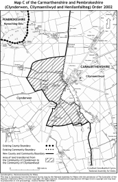
(3) The part of the community of Clynderwen shown hatched in black on boundary map C is separated from that community and forms part of the community of Cilymaenllwyd in Carmarthenshire;
(4) The part of the community of Henllanfallteg in Carmarthenshire shown hatched in black on boundary map D is separated from that community and forms part of the community of Clynderwen.
(5) The part of the community of Clynderwen in Pembrokeshire shown hatched in black on boundary map E is separated from that community and forms part of the community of Henllanfallteg in Carmarthenshire.
Signed on behalf of the National Assembly for Wales
E.Hart
Minister for Finance, Local Government and Communities
6th December 2002


Explanatory Note
(This note is not part of the Order)
This Order, made in accordance with section 58(2) of the Local Government Act 1972, gives effect with modifications to proposals by the Local Government Boundary Commission for Wales. The effect of those modified proposals is that on the coming into force of this Order:
(i)the community of Clynderwen (shown hatched in black on boundary map A referred to in Article 2 of the Order) will be transferred from Carmarthenshire and become part of Pembrokeshire.
(ii)the area which is part of the community of Cilymaenllwyd in Carmarthenshire (including land and property known as “Troed y Rhiw”) (shown hatched in black on boundary map B referred to in Article 2 of the Order) will become part of the community of Clynderwen in Pembrokeshire;
(iii)the area which is part of the community of Clynderwen (shown hatched in black on boundary map C referred to in Article 2 of the Order) will become part of the community of Cilymaenllwyd in Carmarthenshire;
(iv)the area which is part of the community of Henllanfallteg in Carmarthenshire (shown hatched in black on boundary map D referred to in Article 2 of the Order) will become part of the community of Clynderwen in Pembrokeshire.
(v)the area which is part of the community of Clynderwen in Carmarthenshire in the vicinity of Pen-deri Farm (shown hatched in black on boundary map E referred to in Article 2 of the Order) and which does not include any dwellings will become part of the community of Henllanfallteg in Pembrokeshire so that the boundary in that area will follow the centre of the Afon Daulan.
Prints of the boundary maps are deposited and may be inspected during normal office hours at the offices of Carmarthenshire County Council at County Hall, Carmarthen, Pembrokeshire County Council at County Hall, Haverfordwest and at the offices of the National Assembly for Wales at Cathays Park, Cardiff (Local Government Modernisation Division).
The Local Government Area Changes Regulations 1976 (as amended) referred to in Article 2 of this Order contain incidental, consequential, transitional and supplementary provisions about the effect and implementation of orders such as this.
(1)
(2)
See National Assembly for Wales (Transfer of Functions) Order 1999 (S.I. 1999/672).
Options/Help
Print Options
PrintThe Whole Instrument

Mae deddfwriaeth ar gael mewn fersiynau gwahanol:
Y Diweddaraf sydd Ar Gael (diwygiedig):Y fersiwn ddiweddaraf sydd ar gael o’r ddeddfwriaeth yn cynnwys newidiadau a wnaed gan ddeddfwriaeth ddilynol ac wedi eu gweithredu gan ein tîm golygyddol. Gellir gweld y newidiadau nad ydym wedi eu gweithredu i’r testun eto yn yr ardal ‘Newidiadau i Ddeddfwriaeth’. Dim ond yn Saesneg y mae’r fersiwn ddiwygiedig ar gael ar hyn o bryd.
Gwreiddiol (Fel y’i Deddfwyd neu y’i Gwnaed) - Saesneg: Mae'r wreiddiol Saesneg fersiwn y ddeddfwriaeth fel ag yr oedd pan gafodd ei deddfu neu eu gwneud. Ni wnaed unrhyw newidiadau i’r testun.
Gwreiddiol (Fel y’i Deddfwyd neu y’i Gwnaed)-Cymraeg:Y fersiwn Gymraeg wreiddiol o’r ddeddfwriaeth fel yr oedd yn sefyll pan gafodd ei deddfu neu ei gwneud. Ni wnaed unrhyw newidiadau i’r testun.
Dewisiadau Agor
Dewisiadau gwahanol i agor deddfwriaeth er mwyn gweld rhagor o gynnwys ar y sgrin ar yr un pryd
Rhagor o Adnoddau
Gallwch wneud defnydd o ddogfennau atodol hanfodol a gwybodaeth ar gyfer yr eitem ddeddfwriaeth o’r tab hwn. Yn ddibynnol ar yr eitem ddeddfwriaeth sydd i’w gweld, gallai hyn gynnwys:
- y PDF print gwreiddiol y fel deddfwyd fersiwn a ddefnyddiwyd am y copi print
- rhestr o newidiadau a wnaed gan a/neu yn effeithio ar yr eitem hon o ddeddfwriaeth
- manylion rhoi grym a newid cyffredinol
- pob fformat o’r holl ddogfennau cysylltiedig
- slipiau cywiro
- dolenni i ddeddfwriaeth gysylltiedig ac adnoddau gwybodaeth eraill
Rhagor o Adnoddau
Defnyddiwch y ddewislen hon i agor dogfennau hanfodol sy’n cyd-fynd â’r ddeddfwriaeth a gwybodaeth am yr eitem hon o ddeddfwriaeth. Gan ddibynnu ar yr eitem o ddeddfwriaeth sy’n cael ei gweld gall hyn gynnwys:
- y PDF print gwreiddiol y fel gwnaed fersiwn a ddefnyddiwyd am y copi print
- slipiau cywiro
liciwch ‘Gweld Mwy’ neu ddewis ‘Rhagor o Adnoddau’ am wybodaeth ychwanegol gan gynnwys
- rhestr o newidiadau a wnaed gan a/neu yn effeithio ar yr eitem hon o ddeddfwriaeth
- manylion rhoi grym a newid cyffredinol
- pob fformat o’r holl ddogfennau cysylltiedig
- dolenni i ddeddfwriaeth gysylltiedig ac adnoddau gwybodaeth eraill
 Mae’r holl gynnwys ar gael dan Drwydded Llywodraeth Agored v3.0 ac eithrio ble nodir yn wahanol. Yn ychwanegol mae’r safle hwn â chynnwys sy’n deillio o EUR-Lex, a ailddefnyddiwyd dan delerau Penderfyniad y Comisiwn 2011/833/EU ar ailddefnyddio dogfennau o sefydliadau’r UE. Am ragor o wybodaeth gweler ddatganiad cyhoeddus Swyddfa Gyhoeddiadau’r UE ar ailddefnyddio.